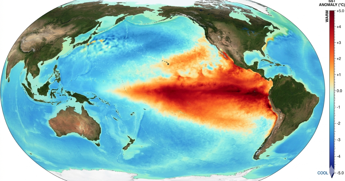
| El Niño is a natural climate pattern caused by unusually warm sea-surface temperatures in the central and eastern tropical Pacific Ocean. It weakens the trade winds, shifts atmospheric circulation, and is associated with drought in some regions and heavy rainfall or flooding in others. |
El Niño is a natural climate pattern and the warm phase of the El Niño–Southern Oscillation (ENSO). It occurs when sea-surface temperatures in the central and eastern tropical Pacific become unusually warm for months at a time, weakening trade winds, shifting atmospheric circulation, and influencing rainfall and temperature patterns far beyond the Pacific.
El Niño develops irregularly, typically every 2 to 7 years, and an episode usually lasts 9 to 12 months. Against a warming global climate, El Niño can contribute to exceptionally high global temperatures, as seen during the 2023–24 episode.
How could El Niño affect weather, food security, and daily life in your region? This guide explains the science behind El Niño, its main impacts, the technology used to monitor it, and practical ways communities can prepare. It also explores the latest 2026 outlook and what it could mean for Pakistan.
| Key Takeaways El Niño is the warm phase of the El Niño–Southern Oscillation (ENSO). What causes it: Weakened trade winds allow warm Pacific surface water to shift eastward. How often it occurs: Approximately every 2 to 7 years. How long it lasts: Typically 9 to 12 months. Main risks: Drought, flooding, heatwaves, food insecurity, and disrupted water supplies. Pakistan: El Niño tends to be associated with below-normal South Asian monsoon rainfall, although impacts vary. How it is monitored: Satellites, ocean observations, climate models, GIS, and statistical/AI techniques. How to prepare: Use forecasts, early-warning systems, risk maps, and climate-resilience planning. Current status: A strong El Niño is developing as of August 2026 and is expected to strengthen further during August–October, with the intensification trajectory peaking around November 2026. |
| El Niño Status: October 2026 NOAA (October 8): The El Niño Advisory continues. A strong to very strong event is likely through January to March 2027. NOAA puts that chance above 83%. Historic strength: NOAA gives an 83% chance that October to December reaches “historic” strength. That means a three-month RONI of +2.5°C or more. It would beat every El Niño since 1950. RONI is NOAA’s index of Pacific warmth. Ocean heat: The key Niño-3.4 zone ran +2.1°C above normal in September. WMO (September 3): The WMO update gives a near 100% chance that El Niño lasts through February 2027. It expects a peak near the end of 2026. Effects will last well into 2027. Food risk: The World Food Programme (WFP) warns that this event could push at least 49 million more people into acute hunger by the end of 2027. The estimate covers 45 countries. Next update: NOAA publishes again on November 12, 2026. Want the full outlook? Read our guide to the super El Niño 2026. |
What Exactly Is El Niño?
El Niño is the warm phase of the El Niño–Southern Oscillation (ENSO), a recurring climate pattern involving interactions between the tropical Pacific Ocean and the atmosphere. It begins when sea-surface temperatures in the central and eastern tropical Pacific become unusually warm, disrupting normal ocean-atmosphere circulation and influencing weather patterns far beyond the Pacific.
The name “El Niño” comes from Peruvian fishermen, who observed unusually warm coastal waters around Christmas. They used the Spanish term “El Niño,” meaning “The Little Boy” or “The Christ Child.” Today, scientists recognize El Niño as one phase of the broader ENSO cycle, alongside La Niña and the neutral phase.
What Causes El Niño?
El Niño occurs when trade winds across the tropical Pacific weaken, allowing warm surface water to move east toward South America. This reduces the upwelling of cold water and changes ocean temperatures, air pressure, and rainfall patterns. These ocean-atmosphere interactions allow El Niño to develop and intensify.
El Niño grows through a chain of steps:
- The trade winds weaken. These winds normally blow from east to west along the equator.
- Warm surface water flows back east toward South America.
- The thermocline flattens. This is the boundary between warm surface water and cold deep water.
- Less cold, nutrient-rich water rises along the South American coast.
- The warm ocean changes air pressure and rainfall over the Pacific.
- These changes spread through winds and jet streams. Scientists call these links teleconnections.
Once it starts, the ocean and the air feed each other. That makes the warming grow. Scientists still study what first sets the process off.
How El Niño Changes Weather Around the World
El Niño weather patterns vary across the world. The event can bring drought and heat to some regions, while increasing rainfall and flood risks in others. These changes occur because warmer Pacific Ocean temperatures affect atmospheric circulation, shifting rainfall patterns and storm tracks.
Strong events can also weaken the monsoon in India and Southeast Asia. These effects are likely, not certain. Local factors always matter.
El Niño vs La Niña: Understanding the Full ENSO Cycle
El Niño is one phase of a larger climate pattern known as the El Niño–Southern Oscillation (ENSO). La Niña is its cool phase, when sea-surface temperatures in the central and eastern tropical Pacific become cooler than average. Together, these phases influence weather patterns around the world.
Here is how they compare:
| Factor | El Niño | La Niña |
| Pacific Ocean | Warmer than normal | Cooler than normal |
| Trade winds | Usually weaker | Usually stronger |
| Australia and Indonesia | Often drier | Often wetter |
| Western South America | Often wetter in some areas | Often drier in some areas |
| South Asian monsoon | May be weaker | May be stronger |
| Pakistan’s rainfall | Effects vary by region and season | Effects vary by region and season |
| Global temperature | Tends to increase global average temperatures | Tends to lower global average temperatures slightly |
| Typical duration | Around 9 to 12 months, sometimes longer | Around 9 to 12 months, sometimes longer |
| Frequency | Occurs irregularly, often every 2 to 7 years | Occurs irregularly, often every 2 to 7 years |
Neither phase is inherently good or bad. Both can increase the risk of extreme weather, but their effects depend on the region, season, and strength of the event.
How Is El Niño Predicted?
Scientists predict El Niño by monitoring ocean and atmospheric conditions across the tropical Pacific. They combine several sources of data to identify developing ENSO patterns and estimate how conditions may change.
Key forecasting methods include:
- Ocean buoys: Measure sea-surface and subsurface temperatures, along with other ocean conditions.
- Satellite observations: Monitor sea-surface temperatures, ocean height, and atmospheric conditions.
- Atmospheric pressure: The Southern Oscillation Index helps track pressure differences across the Pacific.
- Trade winds: Changes in wind strength and direction provide important clues about developing ENSO conditions.
- Climate models: Coupled ocean-atmosphere models simulate how ocean and atmospheric conditions may evolve.
- Statistical and machine-learning models: Analyse current observations and historical patterns to support ENSO forecasts.
Forecasts can provide several months of advance notice, although accuracy varies with the season, model, and stage of the ENSO cycle. Early warnings help governments, farmers, and disaster-management teams prepare for potential weather-related impacts.
How GIS Supports El Niño Monitoring: Geographic Information Systems (GIS) can combine climate forecasts with maps of rainfall, drought, crop conditions, and flood-prone areas. This helps planners identify potentially vulnerable locations and assess where preparation may be needed.
What Are the Effects of El Niño?
El Niño influences weather patterns around the world. Its effects vary by region and can include drought, heavy rainfall, extreme heat, changes in food production, and disruptions to marine ecosystems.
Drought and Heat
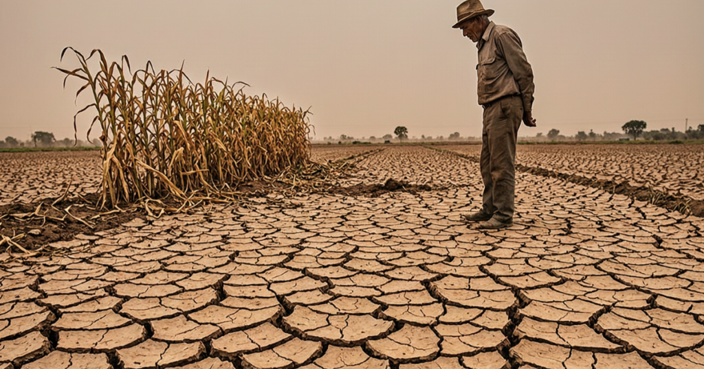
El Niño often increases the risk of drought in Indonesia, Australia, southern Africa, and parts of South Asia. It can also add temporary warming to the effects of human-caused climate change. The 2023–24 El Niño contributed to exceptionally high global temperatures, and 2024 was the warmest year on record at the time.
Floods and Storms
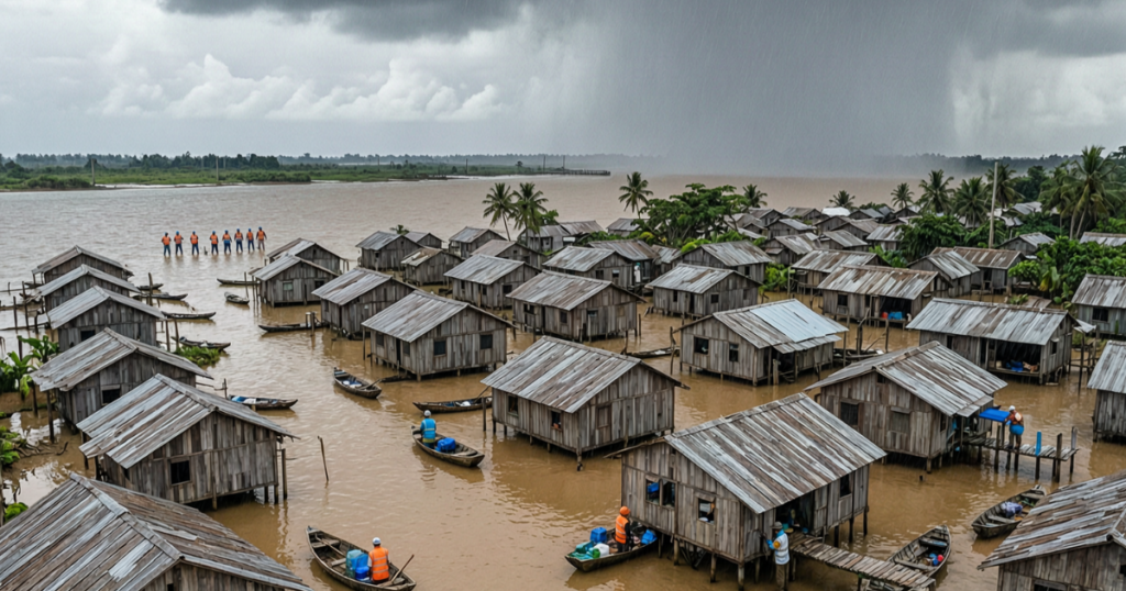
Some regions experience heavier rainfall and flooding during El Niño, including parts of western South America. East Africa can also experience significant rainfall during certain El Niño events. El Niño generally reduces the likelihood of Atlantic hurricanes, but its effects vary across ocean basins and do not eliminate the risk of damaging storms.
Food and Water
Droughts and floods can damage crops, reduce water supplies, and disrupt food production. When agricultural output falls, food prices may rise, placing additional pressure on vulnerable households. The severity of these impacts depends on the strength of the event, local weather conditions, and communities’ ability to prepare.
Health
Extreme heat can increase the risk of heat-related illness, particularly among older adults, outdoor workers, and people without adequate cooling. Flooding and water shortages can also disrupt sanitation and increase certain disease risks. Public health authorities should monitor local conditions and issue guidance suited to the affected area.
Oceans and Wildlife
El Niño warms parts of the tropical Pacific and changes the movement of ocean water and nutrients. Reduced upwelling of nutrient-rich cold water near the South American coast can affect fish populations and fisheries. These changes can disrupt marine food webs and force some species to move to different areas.
What Are the Real-World Impacts of El Niño?
The phenomenon does more than warm the ocean. It reorganises rainfall, shifts monsoon patterns, intensifies drought in some regions, and increases the likelihood of heavy rainfall and storm activity in others.
The 1997–98 episode, one of the strongest on record at the time, is estimated to have caused more than 22,000 deaths and over $36 billion in damages from El Niño-related flooding and drought across Africa, Latin America, North America, and Southeast Asia.
The 2023–24 episode coincided with record global temperatures and contributed to severe flooding in multiple regions. According to the World Meteorological Organisation, 2024 was the first calendar year in which global average temperature exceeded 1.5°C above the pre-industrial average, though a single year crossing that mark is not the same as the Paris Agreement’s long-term threshold being breached, which is assessed over a multi-year average.
How Does the Climate Phenomenon Affect Food Security?
El Niño is associated with intensified drought across Southern Africa, South Asia, and Australia. Crops can fail, water reserves can deplete, and food prices can spike as a result.
During the 2015–16 episode, the agriculture, food security, and nutritional status of roughly 60 million people worldwide were affected by El Niño-related droughts, floods, and extreme temperatures (FAO/WFP, 2016 situation report).
WFP’s August 2026 analysis projects that the strengthening 2026–27 El Niño could push at least 49 million more people into acute food insecurity across 45 vulnerable countries by the end of 2027. Highlighting how food-security risks can build well before the event reaches peak intensity.
Preparing agricultural systems for these cycles is increasingly treated as essential rather than optional. Satellite-based soil-moisture monitoring and AI-assisted irrigation planning are among the tools now available to farming communities facing more intense drought cycles.
Floods and Extreme Rainfall
While some regions dry out, others see the opposite. El Niño is linked to a higher likelihood of heavy flooding in South America, East Africa, and parts of the southern United States. In 2024, severe flooding affected regions including Brazil, Kenya, and the United Arab Emirates, highlighting the complex interaction between climate patterns, extreme rainfall, and local vulnerability.
Flood-risk management becomes more complex in El Niño years, as rivers overflow faster and drainage systems come under greater strain. Urban areas without climate-resilient infrastructure tend to be affected most. GIS mapping services and geospatial flood risk tools help identify which communities face the highest exposure before floodwaters arrive.
Heatwaves and Human Health
El Niño can increase the likelihood or intensity of heat extremes in some regions. It can add temporary warming to an already-warming climate. During the 2023 to 2024 episode, warmth records fell on every inhabited continent.
Separately, climate change contributed to at least 3,700 deaths and displaced millions of people across 26 (of 29 studied) extreme-weather events analysed in 2024, and added an average of 41 extra days of dangerous heat worldwide that year (World Weather Attribution & Climate Central, “When Risks Become Reality,” Dec 2024).
According to Aon’s 2026 Climate and Catastrophe Insight report, extreme heat was responsible for more than 25,000 deaths globally in 2025, the third-hottest year on record, underscoring the growing risk posed by extreme heat without urgent action.
Heat-related mortality can rise sharply during prolonged periods of extreme heat. Elderly populations, outdoor workers, and groups without air conditioning face the greatest risk. Climate resilience strategies combining early heat alerts, urban cooling centres, and green infrastructure can significantly reduce these deaths if deployed before the next event.
How Does Climate Change Affect El Niño Impacts?
El Niño is a natural climate phenomenon, while climate change is driven primarily by human greenhouse-gas emissions. They are different processes, but their effects can overlap.
When El Niño adds temporary warming to an already warmer global climate, it can contribute to exceptionally high temperatures. In some regions, the combination can worsen heat stress, drought, wildfire conditions, or heavy rainfall risks. The exact effects vary by location and event.
Scientists are still investigating how climate change may affect the frequency, intensity, and characteristics of El Niño events. It is therefore important to distinguish established findings about rising global temperatures from areas where scientific uncertainty remains.
For more information, read our climate change in 2026 guide.
How Real-Time Technology Is Changing El Niño Preparedness
Satellite-based remote sensing services now track sea-surface temperatures, atmospheric moisture, and rainfall anomalies in near real time, giving scientists and governments weeks to months of advance warning before impacts peak.
- Satellite monitoring: continuous tracking of ocean temperature, cloud patterns, and rainfall anomalies
- Climate models: coupled ocean-atmosphere models that project how ENSO conditions are likely to evolve
- GIS and geospatial risk mapping: layering flood, drought, and heat exposure data over population and infrastructure maps
- AI and machine learning: models that process large volumes of ocean, atmospheric, and satellite data to sharpen forecasts and flag emerging risk patterns
This is the same machinery now tracking the 2026 event in real time; WMO’s monthly Global Seasonal Climate Update, NOAA’s Climate Prediction Center advisories, and satellite sea-surface-temperature monitoring together produced the high-confidence forecast described earlier in this article.
AI and machine-learning models complement traditional climate forecasting rather than replace it. Real-time vision AI models are particularly useful further downstream, for example, detecting floods, monitoring crop stress, and tracking landscape change from satellite imagery, rather than as the primary tool for predicting ENSO intensity itself.
How Do Scientists Predict El Niño?
No single tool does the job. Forecasters combine several data streams:
- Ocean buoys that measure sea surface temperature
- Satellite monitoring of ocean height, heat, and clouds
- The Southern Oscillation Index, which tracks air pressure differences across the Pacific
- Trade wind strength and direction
- Climate models that link the ocean and the air
- Statistical and AI tools that compare today with past events
NOAA updates its outlook every month. WMO issues its own updates. Forecasts give probabilities, not promises.
What Is a Super El Niño?
“Super El Niño” is a popular label for a very strong event. It is not an official category. WMO ranks events as weak, moderate, strong, or very strong. NOAA says the 2026 event could reach “historic” strength. That means stronger than any event since 1950.
Read the full forecast in our super El Niño 2026 guide.
Who Is Most Vulnerable to El Niño?
El Niño does not affect everyone equally. Low- and middle-income countries tend to bear the heaviest burden; they contribute least to climate change but absorb some of its most severe impacts.
Small island states face existential flooding risk. Sub-Saharan African communities face food-system disruption from drought. South Asian farming communities face monsoon failure. Within any given country, women, children, the elderly, and people living in poverty tend to face the steepest risks, since they typically have the least access to early warnings, financial safety nets, and recovery resources.
Spatial risk intelligence is one of the most powerful tools we have for protecting individuals who can’t defend themselves.
How Does El Niño Affect Pakistan?
Pakistan lies in a region where El Niño often weakens the summer monsoon. The link is not guaranteed. Here is what matters most in 2026:
- Monsoon: PMD research finds that strong El Niño years generally bring less summer rain. PMD’s June outlook warned of below-normal rain and above-normal heat for July to September 2026.
- Crops: Less rain raises irrigation needs for rice, cotton, sugarcane and maize. FEWS NET expects a weak monsoon to cut rice output and delay wheat planting.
- Water: Less rain adds stress to reservoirs and canals.
- Heat and health: Heat stress and dengue risk can rise.
- Uncertainty: The Indian Ocean Dipole and other climate systems can soften the effect.
Read the full outlook in our El Niño in Pakistan guide.
How to Prepare for El Niño
Can we control El Niño? No. El Niño is a natural climate pattern, and there is no proven way to stop it. However, communities can reduce its impacts through early warning systems, water conservation, drought-resistant crops, flood preparedness, and better climate-risk planning. These measures help limit damage to homes, agriculture, water supplies, and public health.
Individuals and households
- Follow your national weather service for monthly updates.
- Know your flood risk and your evacuation route.
- Keep a 72-hour kit with water, food, medicine, and a battery radio.
- Save water during dry spells.
- Check on older neighbors during heatwaves.
Farmers
- Plan planting dates around seasonal outlooks.
- Choose drought-tolerant crops where rain may fall short.
- Use drought monitoring tools to track crop stress.
Businesses
- Map your climate risk by location.
- Stress-test supply chains for drought, flood, and heat.
- Write a continuity plan for El Niño disruption.
Governments
- Fund early warning systems. WMO says they return more than ten times their cost.
- Give 24 hours of notice where you can. The Global Commission on Adaptation says this cuts damage by about 30%.
- Build flood risk maps for every district.
Conclusion
El Niño is a natural cycle with global reach. It can bring drought, floods, heat, and hunger. Its effects differ by region, and they are never certain.
The 2026 event is already strong. Forecasts give early warning. The best response is to act before the peak. See how climate intelligence helps teams map risk before the next shock.
FAQs
What is El Niño in simple terms?
El Niño is a natural climate pattern in which sea-surface temperatures in the central and eastern tropical Pacific become warmer than normal. It changes atmospheric circulation and can influence weather around the world, increasing the likelihood of drought in some regions and heavy rainfall in others.
What causes El Niño?
El Niño develops through interactions between the tropical Pacific Ocean and the atmosphere. Changes in trade winds allow warm surface water to shift eastward, altering ocean temperatures, atmospheric circulation, and rainfall patterns.
How long does El Niño last, and how often does it happen?
El Niño episodes often last around 9–12 months, although some continue longer. They recur irregularly, commonly every 2–7 years. There is no fixed schedule, and the duration and strength of each event vary.
Is 2026 a super El Niño?
“Super El Niño” is an informal term rather than an official classification. In October 2026, NOAA reported an 83% chance that the event would reach its defined threshold for historic strength during October–December. This is a forecast probability, not a guarantee. For the latest outlook, consult NOAA’s Climate Prediction Center and WMO’s seasonal climate updates.
Is El Niño the same as global warming?
No. El Niño is a natural climate pattern that develops over months, while global warming is a long-term rise in global temperatures driven primarily by human greenhouse-gas emissions. El Niño can temporarily add to global warming, contributing to exceptionally high temperatures.
Can scientists predict El Niño?
Yes. Scientists use ocean buoys, satellites, wind and pressure measurements, and coupled ocean-atmosphere models to forecast ENSO conditions. Forecasts can provide several months of advance notice, but their accuracy varies. They provide probabilities rather than guarantees.
How does the climate phenomenon affect Pakistan?
El Niño is often associated with weaker summer monsoon rainfall in parts of South Asia, including Pakistan, but the relationship is not certain. Potential effects include reduced rainfall, greater irrigation needs, and pressure on water supplies. Other climate systems can influence the outcome, so current Pakistan Meteorological Department forecasts should also be considered.
For more information, read our El Niño in Pakistan guide.
How can people prepare for El Niño?
People can follow official weather alerts, prepare emergency supplies, conserve water, and learn about local flood and heat risks. Farmers can use seasonal forecasts to plan planting and irrigation, while businesses and governments can assess exposure and strengthen emergency plans.
How does AI help with El Niño prediction and response?
AI can help analyse large volumes of ocean, atmospheric, and satellite data. GIS platforms can combine climate information with maps of population, infrastructure, agriculture, and hazard exposure. AI-assisted image analysis can also support flood detection and crop-stress monitoring. These technologies complement established climate models and expert forecasting.