| Quick Answer: Super El Niño 2026 refers to a potentially very strong El Niño event. NOAA’s October forecast gives an 83% chance that October to December 2026 will reach historic strength, potentially exceeding any event since 1950. The World Meteorological Organization (WMO) forecasts a peak near the end of 2026, with impacts potentially continuing into 2027. These are forecasts, not confirmed outcomes |
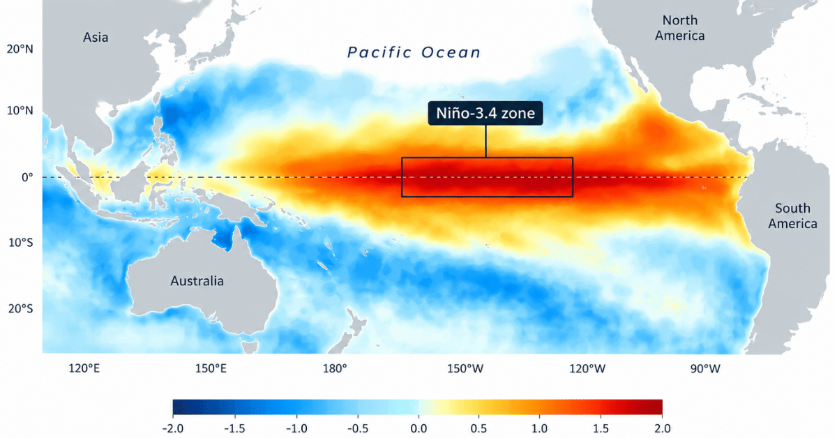
The super El Niño 2026 is dominating the headlines. The label sounds dramatic, but the data is serious too. A very strong event in the El Niño-Southern Oscillation (ENSO) cycle is underway. Pacific sea surface temperatures are far above normal.
This guide explains how strong it could get, how long it will last, and what comes next. It builds on our El Niño explained guide.
Super El Niño 2026: Latest Forecasts
| Source | Date | Key message |
| NOAA | October 8 | El Niño Advisory continues. A strong to very strong event is likely through January to March 2027 (chance above 83%). An 83% chance of historic strength in October to December. |
| WMO | September 3 | Near 100% chance El Niño lasts through February 2027. Peak near the end of 2026. Impacts into 2027. |
| WFP | August 5 | At least 49 million more people could face acute hunger by the end of 2027. |
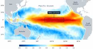
Only one number here is a measurement: NOAA’s September reading of +2.1°C above normal in the key Niño-3.4 zone. The 83% chance, the “very strong” label, and the peak dates are forecasts. NOAA publishes again on November 12, 2026.
What Is a Super El Niño?
Super El Niño is a media label for the strongest El Niño events. It is not an official category. NOAA’s “historic” threshold is a separate, technical definition, not a synonym. Three terms describe the top tier:
- Very strong: the highest level on WMO’s four-step scale (weak, moderate, strong, very strong).
- Historic: NOAA’s label for an event that would beat every El Niño since 1950. NOAA defines it as a three-month RONI of +2.5°C or more.
- Super: the popular label used in news and search. This guide uses it for the 2026 event.
The last two very strong events came in 1997-98 and 2015-16.
| Key Terms in Plain Words: Sea surface temperature (SST) anomaly: how far ocean water sits above or below its long-term average. Niño-3.4: the central Pacific zone that forecasters watch most closely. RONI: NOAA’s Relative Oceanic Niño Index. It adjusts Pacific warmth for the warming of the wider tropical ocean. ENSO-neutral: neither El Niño nor La Niña. Teleconnection: a link between Pacific warming and weather far away. Persistence: how long forecasters expect El Niño to continue. |
How Strong Could the Super El Niño 2026 Get?
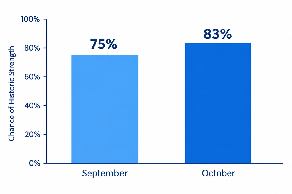
WMO says key Pacific waters already run more than 2°C above normal. NOAA’s chance of historic strength for October to December has climbed from 69% in August to 75% in September and 83% in October. The Met Office goes further. It forecasts Pacific sea surface temperatures more than 3°C above average later in 2026 and calls the event unprecedented.
Agencies use different indices, so their numbers differ. NOAA forecasts the chance of historic strength. It has not confirmed a record. Only observed data after the event can do that. Numbers can move each month.
How Does 2026-27 Compare With Past El Niño Events?
| Event | Strength | Main impact | Source |
| 1997-98 | Very strong. Strongest on record at the time. | More than 22,000 deaths and over $36 billion in damage (estimate) | NOAA/OGP review |
| 2015-16 | Very strong | Hit the food security of 60 to 100 million people | WFP |
| 2023-24 | Major event | Helped push 2024 to the warmest year on record | WMO |
| 2026-27 | Very strong, on track for historic | WFP projects 49 million more people in acute hunger by the end of 2027 | NOAA, WFP |
However, past events are not exact guides, because each El Niño plays out differently.
How Long Will the Super El Niño 2026 Last?
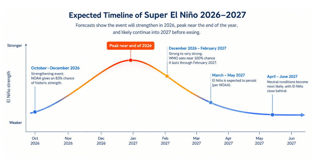
| Period | What forecasters expect |
| Now to December 2026 | El Niño strengthens and peaks near the end of the year (WMO). |
| December 2026 to February 2027 | Strong to very strong. WMO sees a near 100% chance it persists. |
| January to March 2027 | Strong to very strong is likely (NOAA, above 83%). |
| March to May 2027 | NOAA expects El Niño to persist. |
| April to June 2027 | Neutral becomes the most likely state, with El Niño close behind. |
| Later in 2027 | A strong El Niño is often, but not always, followed by La Niña. |
Every row is a forecast, not a confirmed date. Later rows are less certain. Check each monthly update.
Strength Is Not the Same as Impact
A bigger peak does not always mean worse damage. In fact, WMO’s climate prediction chief says impact depends on place and timing. For example, some regions feel effects before the peak. Others feel them during it. Still others feel them after it.
Will 2027 Be the Hottest Year?
El Niño adds a pulse of heat to the planet. That pulse arrives after the Pacific peak. WMO says 2027 has the potential to be the warmest year on record. The Met Office goes further. It calls 2027 very likely to set the record once climate change is added. The current record belongs to 2024, which followed the last strong El Niño.
Heat is already high. September 2026 was the second-hottest September on record, according to Yale Climate Connections. For more on global heat, read our climate change in 2026 guide.
What Will the Super El Niño 2026 Mean for the US, Canada and the UK?
El Niño reaches North America and Europe most strongly in winter. These are odds, not forecasts.
| Region | What agencies say | Source |
| United States | Warmer than normal across the West, the northern states and parts of the East. Wetter across the south, from Southern California through Texas and the Gulf Coast to the Southeast. Drier in the Pacific Northwest and northern Rockies. | NOAA seasonal outlook |
| Canada | A milder winter with less snow across western, northwestern and central Canada. A warmer, drier spring. | Environment and Climate Change Canada |
| United Kingdom | Wetter and stormier weather is more likely in autumn and early winter. Colder, calmer spells can become more likely in January and February. | Met Office |
Each El Niño winter is different. NOAA updates its outlook every month, so check the latest map. Also, the Met Office stresses that El Niño is one of several factors that shape UK weather.
Who Faces the Biggest Risks?
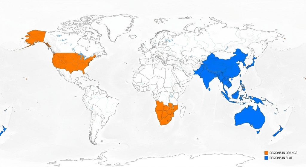
| Region | Main risk | Source |
| Southern Africa | Acute hunger could rise by nearly 75%. More than 12 million more people are at risk. | WFP |
| Latin America and the Caribbean | More than 16 million people could face rising hunger. | WFP |
| Asia and the Pacific | About 8.2 million more people could face acute hunger. | WFP |
| Indonesia | Dry spells can cut palm oil output. | Sky News |
| South Asia | The monsoon is often weaker. | National Geographic |
WFP’s figures are projections, not confirmed outcomes. They depend on how the event unfolds and on local conditions.
What It Means for Food and Prices
WFP studied 45 countries that already face food stress. It expects acute hunger there to rise from about 225 million to about 274 million people, a rise of about 22%. This is a projection from WFP’s August 5 analysis, not a confirmed count. The 2015-16 El Niño hit the food security of 60 to 100 million people. Harvests lag behind weather, so the effects will last through 2027.
What About Pakistan?
Pakistan is a region to watch. PMD research links strong El Niño years with weaker summer rain. The main risks are less monsoon rain, higher irrigation needs for rice and cotton, and pressure on water supplies. Other systems, such as the Indian Ocean Dipole, can soften the effect. Read our full guide to El Niño in Pakistan.
What Can You Do Now?
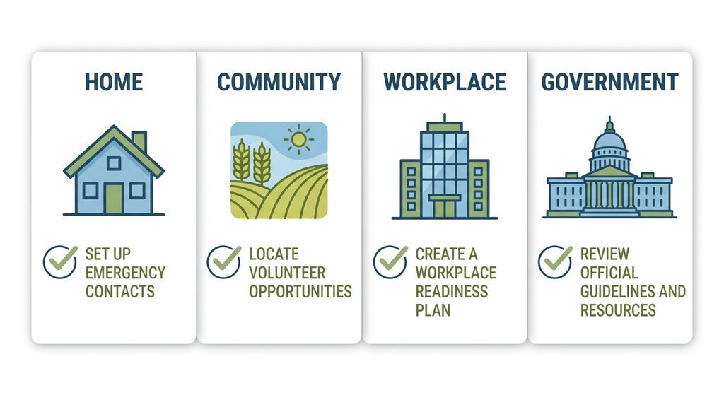
WMO says El Niño does not have to end in disaster. Early action works.
- Follow the forecast. Check your national weather service each month.
- Know your risk. Learn your local flood and heat exposure.
- Farmers: Adjust planting dates. Choose drought-tolerant crops where rain may fall short.
- Businesses: Stress-test supply chains for drought, flood, and heat.
- Governments: Fund early warning. WMO says these systems return more than ten times their cost. Just 24 hours of notice can cut damage by about 30%, says the Global Commission on Adaptation.
For full preparation steps, use our El Niño preparation checklist.
Geospatial tools help here. See how GeoAI early warning supports risk planning. Also read about flood risk monitoring with GIS and remote sensing.
How AI Geo Navigators Uses Climate Forecasts
AI Geo Navigators is an Islamabad-based climate-intelligence and geospatial firm. It combines satellite data, weather models, and ground inputs with AI to support early warning and climate-risk analytics. Forecasts from NOAA and WMO are one input. Local risk maps turn them into action. Learn more about our early warning and climate risk services.
Conclusion: What the Super El Niño 2026 Means for You
The super El Niño 2026 is a forecast-driven story, but the signals are strong. NOAA, WMO, and WFP all expect a very strong event. It should peak near the end of 2026 and shape weather, food, and heat into 2027. However, forecasts will change. Check each monthly update, know your local risk, and act early. See how climate intelligence helps teams map risk before the next shock.
FAQs
Is 2026 a super El Niño?
It is on track to become one, but that is a forecast. “Super” is a popular label, not an official category. WMO expects a very strong event. NOAA gives an 83% chance of historic strength in October to December 2026. Check each monthly update.
When will the 2026 El Niño peak and end?
WMO expects a peak near the end of 2026. It sees a near 100% chance that El Niño lasts through February 2027. NOAA expects it to persist through March to May 2027. Neutral conditions become most likely in April to June 2027.
Will 2027 be the hottest year on record?
It could be. WMO says 2027 has the potential to be the warmest year on record. El Niño’s heat pulse arrives after the Pacific peak. The record today belongs to 2024. Nothing is certain until the data is in.
Is the 2026 El Niño stronger than 1997-98?
It could be. NOAA gives an 83% chance of historic strength in October to December 2026. That would beat every event since 1950, including 1997-98. The Met Office calls the event unprecedented. The final ranking depends on observed data, so wait for NOAA’s confirmed numbers.
What will a super El Niño do to winter in the US, Canada and the UK?
The northern US tends to turn warmer, and the south tends to turn wetter. Western and central Canada tend to see a milder, less snowy winter. The UK has a higher chance of wet and stormy weather early, and colder spells later. These are odds, not guarantees, so check your national weather service.