We turn global forecasts, satellite data and local station readings into weather information for one site, corridor or district. Your teams get forecasts, alerts and data they can act on.
Illustrative data, not a live feed or forecast.
Site level
forecasts for a plant, corridor or district
Short range
nowcasts and rolling forecasts
Your thresholds
alerts set for your operations
API or dashboard
delivery into the tools you use
We start from the decision you need to make, then build the forecast around it. A crane operator, a dam manager and a district officer need different answers from the same weather.
Forecasts adjusted for your terrain, land surface and elevation.
Rapid short-range updates for weather already developing near your site.
Machine learning that adds local detail and corrects known model errors.
Warnings tied to the conditions that stop or change your work.
Clean weather records and forecast feeds for your own systems.
Weather advice built into planning for sensitive work.
Five stages, from the first conversation to a forecast your team uses every day.
We list the sites, the weather variables and the thresholds that matter.
Requirements and thresholds
We review station records, model options and data gaps for your area.
Data and model plan
We configure the forecast chain and correct it against local observations.
Calibrated forecast chain
We test forecast skill against observations held back from calibration.
Skill report
We deliver alerts and data, track performance and retrain when needed.
Live service and reports
The platforms and projects closest to this service.
Platform · Live
Climate intelligence platform with a hazard map, live and forecast views, GLOF screening and weather stations.
Live platform
Platform · Live
Multi-model climate forecasting for operations in Saudi Arabia.
Live platform
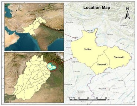
Sialkot and Narowal, Punjab · Aug 2025
Flood extent from Sentinel-1 radar with CHIRPS rainfall to explain the drivers.
1,045 km² affected land mapped
We combine model output with stations, satellites and terrain, then check the result against local observations.
Every alert links to an action your team has agreed, so a warning is more than a color on a map.
Our information security management is certified to ISO/IEC 27001.
Climate, GIS, AI and software specialists work in one team, with offices in Islamabad, Lahore, Gilgit and Delaware.
We choose inputs and methods to fit the site, the lead time and the budget.
Tell us the problem and the area. We will suggest the simplest way to solve it.
It means weather information built for a specific place, such as a site, a valley or a transport corridor, using local terrain and observations alongside larger forecast models.
Apps give a general forecast for a place name. This service is built around your location, your thresholds and your decisions, and we measure its performance against local observations.
Accuracy depends on the variable, the lead time, the terrain and the local data. We report measured skill for your site. We do not quote one accuracy figure for every location.
Not always, but local observations improve calibration and validation. We can assess existing stations and advise where new ones would help. See live monitoring systems.
Through dashboards, APIs, scheduled files, SMS or email. We agree the format and the escalation path during scoping.
Construction, energy, water, agriculture, logistics, disaster management and any operation where weather changes the plan.
Climate Tech Services
Downscaled climate projections for planning horizons, with uncertainty stated.
Climate Tech Services
Flood, GLOF, landslide, heat and drought models that show where a hazard can reach.
Climate Tech Services
Automatic weather stations, industrial sensors and telemetry, installed and maintained.
Tell us the location, the decisions and the deadline. We will reply with a clear plan and a quote.
