The El Niño crisis in Pakistan is one of the most alarming climate warnings in years. In May 2026, the Pakistan Meteorological Department confirmed a 61% probability that El Niño would develop between May and July. The potential for a “Super El Niño” by late August makes this especially dangerous.
This is not a future risk. It is happening now. The only realistic line of defense sits at the intersection of artificial intelligence, geospatial analytics, and real-time climate data.
This article breaks down exactly what El Niño does to Pakistan, why the 2026 outlook is especially serious, and how AI GEO is building tools that could protect millions of lives.
What is El Niño, and why does Pakistan face the Worst of it
El Niño is a naturally occurring climate phenomenon driven by the warming of surface waters in the central and eastern equatorial Pacific Ocean. It disrupts normal wind and rainfall patterns worldwide through the El Niño Southern Oscillation (ENSO).
For Pakistan, the consequences are severe, cascading, and well-documented. Understanding El Niño crises in the Pakistani context requires knowing two key regional amplifiers that most coverage misses entirely.
The ENSO-Monsoon Suppression Mechanism

When El Niño strengthens, it weakens the South Asian monsoon jet stream. PMD spokesperson Anjum Nazir Zaigham confirmed that El Niño suppresses the summer monsoon across the subcontinent.
The June to September monsoon window irrigates crops across Punjab, Sindh, and KPK. During El Niño years, this window either:
- Arrives significantly late
- Underperforms across key agricultural zones
- Bypasses critical farming regions entirely
That means less water precisely when Pakistan needs it most.
The Indian Ocean Dipole: The Hidden Variable
Most articles discussing El Niño and Pakistan never mention the Indian Ocean Dipole (IOD). This is a critical gap.
The IOD is a separate ocean-atmosphere system that can either amplify or partially offset El Niño’s impact on Pakistan’s rainfall. The SASCOF-34 climate forum confirmed in May 2026 that:
- Neutral IOD conditions are currently prevailing
- A positive IOD phase is likely to emerge later in the monsoon season
- However, if it arrives after the kharif crop window closes, it offers little real protection for food security
The 2026 Super El Niño Warning
The current threat is not routine. PMD officials warned that a Super El Niño by late August 2026 could make 2027 the hottest year ever recorded in human history.
The last El Niño in 2023-24 already made 2024 the all-time temperature high. A Super El Niño building on that elevated baseline means Pakistan enters this cycle with far less natural resilience than during any previous ENSO event.
To understand the full science behind these compounding patterns, this detailed breakdown of global El Niño impacts, risks, and what communities can do to prepare is essential reading.
El Niño Crisis in Pakistan: Five Vectors
The El Niño crises in Pakistan are not limited to floods or droughts in isolation. They cascade across five interconnected systems simultaneously, and most coverage focuses on only one or two of them.
Agricultural Collapse and Food Security

Pakistan’s agriculture sector contributes around 20% of GDP and employs nearly 37% of the labor force. The 2022 mega-flood, strongly linked to ENSO anomalies, caused:
- A 4.6 million ton reduction in wheat output
- Destruction of 40% of the cotton crop
- Submersion of 70% of Sindh province at peak inundation
With 2026 El Niño expected to suppress rainfall, drought-induced crop failure now threatens Punjab and Balochistan, the country’s breadbasket provinces.
AI-powered precision tools are now Pakistan’s frontline response for protecting food production. This deep dive into smart agriculture solutions that are raising yields and building resilience shows exactly how technology is reshaping farming under erratic climate conditions.
The Hydropower and Energy Crisis Angle
This is the dimension almost no article addresses. Pakistan generates a significant share of electricity from hydropower fed by glacial melt and monsoon runoff in the Indus basin.
When El Niño disrupts glacial melt patterns in the Hindu Kush-Karakoram-Himalayan region and suppresses monsoon rainfall simultaneously:
- Reservoir levels fall sharply
- Hydropower output drops significantly
- Load-shedding costs billions in industrial losses
The El Niño crisis in Pakistan is not merely a weather crisis. It is an energy crisis hiding in plain sight. This article on clean energy solutions driving climate resilience outlines practical pathways to reduce this vulnerability.
Heatwave Public Health Emergencies
The 2026 PMD heatwave alert warned that temperatures in southern Punjab, upper Sindh, and southeastern Balochistan, already running 2°C to 4°C above normal, could reach 52°C during the El Niño onset phase.
Sustained temperatures above 45°C trigger:
- Mass hospital admissions and heat stroke fatalities
- Vector-borne disease expansion from stagnant water
- Overwhelmed health infrastructure across the affected provinces
The pattern of how these extreme events are accelerating is explored thoroughly in this analysis of how the world’s extreme weather events have fundamentally and permanently changed.
Glacier Lake Outburst Floods (GLOFs)

Pakistan holds more glaciers than any non-polar nation on Earth. El Niño-driven temperature spikes accelerate glacial melt in the Karakoram and Hindu Kush ranges, raising the risk of Glacier Lake Outburst Floods.
Key facts:
- GLOFs send walls of water down narrow mountain valleys with almost no warning
- Gilgit-Baltistan and Chitral experienced 16 confirmed GLOF events in 2022 alone
- AI-powered satellite monitoring is now the primary early detection tool for these threats
This capability is directly supported by the geospatial intelligence work that GIS specialists are applying to save ecosystems and communities across Pakistan.
Displacement and Economic Loss
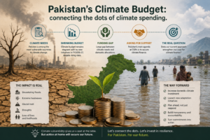
The 2022 Pakistan floods displaced 33 million people and caused over $30 billion in economic losses, according to NDMA Pakistan. Research published in Nature (2025) projects that high flood-risk zones in Pakistan will expand by 6.62% by 2080 under an SSP5 climate scenario.
Without advanced predictive infrastructure, each El Niño cycle compounds these numbers further. The El Niño crisis in Pakistan demands more than awareness; it demands intelligence. Explore how AI Geo Navigators delivers real-time climate risk adaptation and early warning solutions for governments, NGOs, and agricultural organizations.
AI Climate Solutions Pakistan: How AI GEO Bridges the Data Gap
AI GEO transforms raw satellite and sensor data into decision-ready intelligence. In Pakistan’s context, this means taking climate data that already exists, but is locked behind technical barriers, and making it actionable for farmers, district officers, health workers, and emergency planners.
A 2025 study in the International Journal of Disaster Risk Reduction produced Pakistan’s first national-scale, high-resolution (30-meter) flood susceptibility maps using integrated AI and machine learning. Their population exposure estimates came in 30% larger than previous methods, meaning earlier disaster response plans were systematically underestimating risk.
For a grounded understanding of how climate intelligence is deployed, this piece on how AI Geo Navigators converts climate data into the best results for a smarter, safer planet provides excellent context.
Remote Sensing and Satellite Monitoring
Remote sensing satellites, including NASA’s MODIS, ESA’s Sentinel-2, and NOAA’s AVHRR, provide daily imagery of Pakistan’s river basins, glacier zones, and agricultural areas.
AI computer vision algorithms can now:
- Detect flood boundaries within hours of an event
- Track glacier retreat rates continuously
- Monitor soil moisture across entire provinces
What previously required a field survey team of three to five days can now be completed in two to six hours. This comprehensive breakdown of the ten most powerful remote sensing techniques transforming climate and disaster monitoring explains exactly how these tools work at scale.
NDVI Crop Stress Detection
The Normalized Difference Vegetation Index (NDVI) measures vegetation health directly from satellite data. When El Niño-driven drought stresses Pakistan’s crops, NDVI values drop measurably three to six weeks before any visible crop failure appears on the ground.
AI GEO platforms flag these declines automatically and route alerts to provincial agricultural departments. This provides a critical window to:
- Activate irrigation support before shortfalls worsen
- Adjust water canal allocations across affected districts
- Trigger early food procurement programs before a humanitarian crisis develops
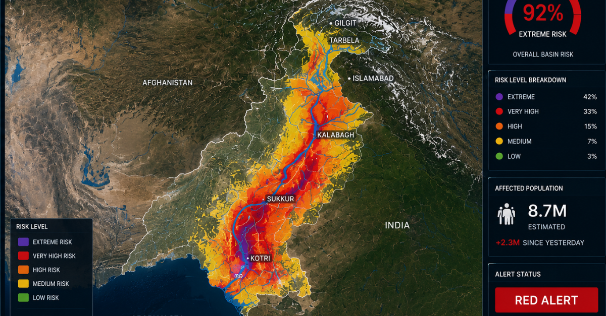
Machine Learning Flood Susceptibility Mapping
A January 2025 study of the Sheikhupura district demonstrated that machine learning models for flood risk assessment achieved an AUC score of 0.92 — 92% accuracy in identifying flood-prone areas before any event occurs.
These models integrate:
- Elevation data and river proximity
- Land use classification and soil permeability
- Historical flood extents updated with real-time satellite inputs
The result is a living risk map that evolves with conditions rather than sitting as an outdated static document. See this guide to GIS mapping services that turn spatial data into smarter, faster decisions for a deeper look.
Predictive Modeling: The Statistical Engine Saving Pakistani Lives

Predictive modeling is where rigorous statistical methodology meets real-world climate response. In the El Niño crisis in Pakistan, three model families are doing the heaviest analytical lifting.
Traditional vs AI GEO Response: A Direct Comparison
| Crisis Dimension | Traditional Approach | AI GEO Approach |
| Flood detection | Ground survey: 3-5 days | Satellite AI analysis: 2-6 hours |
| Drought early warning | Seasonal forecast: 3 months out | NDVI + ML scoring: weekly updates |
| GLOF detection | Manual mountain monitoring posts | AI satellite change detection |
| Crop loss estimation | Manual field survey reports | Remote sensing regression models |
| Heatwave health risk | General PMD weather bulletins | District-level probability scores |
| Data access | Centralized: scientists only | Democratized: field officers and farmers |
| Forecast confidence | Deterministic: binary yes/no | Bayesian: probability range with uncertainty |
LSTM Neural Networks for River Flood Forecasting
Long Short-Term Memory (LSTM) neural networks are trained on 50-70 years of hydrological records from the Indus basin. A 2025 study in Nature using the FloodCast system demonstrated that coupling historical data with advanced machine learning can both quantify the drivers of catastrophic flood events and project future risk scenarios.
For Pakistan’s 2022 mega-flood, analysis revealed:
- The monsoon delivered 7-8 times the 1990-2020 average rainfall
- In Balochistan, dam failures caused 80-85% of the province’s total economic losses
- Better predictive susceptibility mapping could have substantially mitigated these losses
Bayesian Probabilistic Forecasting
A persistent weakness in Pakistan’s disaster response has been overconfident binary predictions that produce either false alarms or missed evacuations.
Bayesian inference models replace these with calibrated probability ranges. For example: a 78% probability of flood peak exceeding 50,000 cusecs in the next 72 hours, with a confidence interval of ±12%.
This allows emergency coordinators to make risk-graded decisions:
- Pre-position barriers at 70% confidence
- Issue evacuation advisories at 80% confidence
- Issue mandatory evacuation orders at 85% confidence
Rather than waiting for the certainty that dynamic climate systems never provide.
Random Forest Drought Probability Scoring
Random forest classifiers analyze combinations of:
- Sea surface temperature anomalies
- Soil moisture satellite readings
- NDVI vegetation indices
- Historical drought records
These inputs produce weekly drought probability scores for each district in Pakistan. With the 2026 El Niño now developing, these models are already showing elevated drought probability signals across central South Asia.
The AI and machine learning capabilities driving these applications are explained in detail in this guide to AI-powered GIS mapping services that deliver smarter, real-world results.
Early Warning Systems Pakistan: From Satellites to Farmers’ Phones

An early warning system is only as effective as its last mile, the precise moment climate data reaches someone with both the authority and the ability to act on it.
Pakistan’s historical challenge has not been a shortage of climate data. It has been the translation gap between raw technical outputs and frontline decision-makers in the field.
How AI GEO Closes the Last-Mile Gap
AI GEO platforms combine automated alert thresholds with multi-channel delivery. When flood risk scores exceed defined limits, the system automatically pushes:
- SMS alerts to district emergency coordinators
- Email notifications to provincial agriculture departments
- Mobile dashboard updates to registered field officers and community wardens
In Balochistan’s 2023 drought response, NDVI-based early warnings enabled districts to begin water rationing protocols three weeks earlier than in comparable previous seasons.
Open Data Dashboards for Provincial Governments
Pakistan’s provincial governments are increasingly deploying open geospatial dashboards updated daily from satellite feeds. These platforms display:
- Flood inundation extent across affected districts
- Crop stress indices at the union council level
- River level gauges and rainfall anomaly maps
District commissioners and agricultural extension officers access them without requiring any technical training. This comprehensive framework on the ten best climate resilience solutions for survival in 2026 is required reading for any planner working in Pakistan’s climate space.
Real-Time Vision AI: The Next Frontier
Beyond traditional satellite imagery processing, real-time vision AI models are now capable of:
- Detecting flood boundaries from aerial and drone feeds
- Identifying infrastructure damage in near real-time
- Assessing crop loss within hours of an extreme event
This article explores how real-time vision AI models are revolutionizing human life on Earth, including their direct applications to disaster monitoring and climate resilience operations.
The 2026 Response Window
The PMD’s current 61% El Niño probability forecast for May-July 2026 is not a cause for panic. It is a cause for immediate, structured preparation.
Governments that use this window effectively will:
- Pre-position relief resources before conditions peak
- Advise farmers on drought-tolerant crop switching in advance
- Activate water conservation protocols 8-12 weeks before peak impact
Those who wait for conditions to deteriorate visibly will face substantially higher losses.
Conclusion
The El Niño crisis in Pakistan is not a distant projection; it is the climate reality of 2026. With PMD confirming a high probability of El Niño development and warning of a potential Super El Niño by late August, the preparation window is measured in weeks, not months.
You now understand both dimensions of this crisis: the science of how El Niño simultaneously disrupts Pakistan’s monsoon, energy supply, agriculture, public health, and fragile mountain ecosystems, and the tools that AI GEO brings to bear against each of these threats.
Pakistan has demonstrated resilience through every ENSO cycle it has faced. With AI GEO-powered predictive analytics, that resilience becomes systematic, data-driven, and proactive rather than reactive and costly. Explore AI Geo Navigators’ climate intelligence solutions for Pakistan and take the first step toward building real data-driven resilience for your organization or community.
FAQs
What is the El Niño crisis in Pakistan in 2026, and how serious is it?
The Pakistan Meteorological Department has confirmed a 61% probability of El Niño forming between May and July 2026. It could intensify into a Super El Niño by late August, suppressing the monsoon, pushing southern temperatures above 52°C, and triggering widespread drought. Building on 2024’s record global temperatures, this represents an unprecedented climate risk for Pakistan’s agriculture, people, and economy.
How does AI GEO help Pakistan respond to the El Niño crisis?
AI GEO combines satellite remote sensing with artificial intelligence to detect, predict, and communicate climate risks in near real-time. It detects flood extents within hours, produces weekly district-level drought scores, and delivers automated alerts to emergency coordinators and farmers via mobile platforms, turning existing climate data into actionable intelligence without requiring technical expertise.
What is the difference between El Niño and Super El Niño for Pakistan?
A standard El Niño in Pakistan weakens the monsoon and raises temperatures. A Super El Niño does the same at significantly greater intensity and duration. For Pakistan, this means below-normal rainfall during the critical June-September agricultural window, more severe heatwaves in the south, and cascading effects on hydropower and food security extending well into 2027.
What predictive models are used to forecast El Niño impacts in Pakistan?
Three key model families are used. LSTM neural networks provide 72-hour flood forecasts from 50-70 years of Indus basin hydrological data. Random forest classifiers generate weekly district-level drought probability scores. Bayesian inference frameworks replace binary predictions with calibrated probability ranges that emergency planners can act on at defined confidence thresholds.
How does the Indian Ocean Dipole affect El Niño impacts on Pakistan?
The IOD can partially counterbalance El Niño’s suppression of South Asian monsoon rainfall. The SASCOF-34 forum confirmed a positive IOD phase is likely later in the 2026 monsoon season. However, if it arrives after the kharif crop window closes, it provides limited practical protection for food security. AI GEO platforms incorporating IOD data produce substantially more accurate regional forecasts as a result.
Can Pakistan’s hydropower sector be protected from El Niño impacts using AI?
Yes, meaningfully. AI GEO systems monitor glacier retreat via satellite, track Indus basin snowpack levels, and model seasonal reservoir inflows. This gives hydropower operators 4-8 weeks of advance notice to adjust generation schedules and coordinate emergency contingencies, significantly reducing economic damage from unplanned load shedding cascades.
What role does biodiversity monitoring play in El Niño resilience for Pakistan?
El Niño degrades forests, dries wetlands, and stresses the biodiversity buffers that naturally moderate flood and drought extremes. Satellite-based biodiversity monitoring gives planners early visibility into ecosystem degradation before it becomes irreversible. This guide on monitoring biodiversity to protect our planet covers how these frameworks are protecting Pakistan’s natural systems.