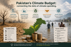
Pakistan is responsible for less than 1% of the global carbon emissions. However, it ranks among the top ten highly climate change affected countries. The 2022 flooding was an event that cost 40 billion dollars. So, the fundamental issue here is how did the banking system in Pakistan react? The State Bank of Pakistan has […]
Background: The mountainous regions of Pakistan, particularly Gilgit-Baltistan, Swat, and Chitral, are highly vulnerable to landslides, flash floods, seismic activity, glacial lake outburst floods (GLOF), and other climaterelated hazards. Rugged terrain, fragile geology, and increasing climate variability amplify risks to lives, infrastructure, and ecosystems. Unplanned housing expansion on steep slopes, riverbanks, or high-risk areas further […]
ABSTRACT Management of infectious diseases in remote nomadic communities is a problematic affair because these people are mobile, geographically isolated, and have limited access to health facilities. This review will address diagnostic and predictive disease modeling systems among people on the move using Geographic Information Systems (GIS). It analyses how GIS has been used in […]
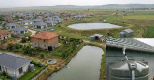
1. Background: The Hindu Kush Himalaya (HKH) region of Pakistan is highly vulnerable to natural hazards including landslides, flash floods, and seismic activity due to its rugged terrain, fragile geology, and changing climate. As communities continue to expand in these high-risk zones, the need for safe, sustainable housing has become increasingly urgent. This case study […]
Abstract The monsoon in August 2025 brought severe flooding in the Sialkot and Narowal districts of Punjab, Pakistan, affecting about 1,045 km² of land. This research combines Sentinel-1 Synthetic Aperture Radar (SAR), and CHIRPS daily rainfall data to map flood extent and evaluate hydrological drivers. Sentinel-1 SAR data facilitated accurate flood delineation even in cloudy […]