The frequency of natural disasters are increasing rapidly, both in terms of their number and severity. Floods, for example, are catching urban areas totally unexpected, landslides are becoming more frequent in mountainous terrains, wildfires are spreading across arid zones, and heatwaves are becoming more prolonged. All these hazards are becoming more severe due to climate change, urbanization, deforestation, and the unwise use of land.
For years, disaster risk management has relied heavily on historical records, static hazard maps, and reactive emergency response systems. These tools are largely reactive. They can tell us where disasters have happened, but they cannot tell us where they might occur. This is especially true at a time when climate change and environmental uncertainty is increasing. The gap between exposure to hazards and our ability to manage these has widened, which has initiated the development of more predictive tools.
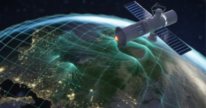
The development of GeoAI, is the integration of geospatial technologies with artificial intelligence, a revolutionary change from traditional disaster risk management. This technology allows for the prediction of disasters by using satellite images, climate models, terrain models, and other tools. This technology is different from traditional tools, which largely depend on historical records. GeoAI, on the other hand, models complex, non-linear relationships between various environmental factors to predict disasters. This article is a comprehensive overview of GeoAI technology for disaster risk prediction.
Understanding GeoAI: From Static Maps to Predictive Systems
GeoAI, refers to the use of artificial intelligence and machine learning in relation to geospatial data. It combines geographic information systems, remote sensing, and artificial intelligence and machine learning in analyzing patterns and events that trigger a disaster.
GIS (geographic information systems) has been a powerful tool in the analysis and visualization of geospatial data, especially in relation to describing various patterns and events that trigger a disaster, like a flood hazard map, identifying exposed infrastructure, and summarizing historical events. GIS has been a powerful tool in describing events, but it has been limited in its ability to predict and forecast events, as it relies on rules and decision-making algorithms that are often based on the assumption that relationships are constant and unchanging.
However, a disaster, like a flood, is often the product of a combination of various factors, which are non-linear in nature, and are dependent on variables like the weather, terrain, and infrastructure, among others. GeoAI, has been able to address this challenge by providing a platform that can predict and forecast events, unlike GIS.
For example, a GIS-based flood hazard map may provide a classification of areas that are either hazardous or safe, depending on historical flood events, while a GeoAI-based system may provide a prediction of the chances of a flood occurring in a particular place and time, depending on various factors like rainfall, soil moisture, and terrain, among others.
Why Traditional Disaster Risk Models Are No Longer Enough
Conventional disaster risk models are facing a challenge to effectively address the realities of the contemporary world:
- Climate non-stationarity: Past climate variability is not a good guide to future climate variability.
- Significant changes in land use: can result in changes to runoff, slope stability, and heat exposure faster than hazard maps can be revised.
- The sheer volume and velocity of data: from satellites, weather modeling, and sensors overwhelm traditional manual analysis.
- Compound and cascading disasters: for example, floods causing landslides or heatwaves causing power outages, are hard to model individually.
GeoAI is built to handle high-dimensional data and non-linear relationships and is therefore better suited for addressing the realities of the contemporary world and providing effective disaster risk prediction.
Types of Disasters Where GeoAI Is Making a Difference
GeoAI is being used for a broad spectrum of different disasters, each with unique data and modeling characteristics.
Flood Risk Prediction
Flooding is the most common and economically damaging type of climate-related disaster globally. GeoAI-based flood prediction combines:
- Satellite-based precipitation data
- River networks and drainage density
- Digital elevation model (DEM)
- Soil and land cover data
- Impervious surface data for urban areas
Machine learning algorithms learn how different levels of rainfall intensity interact with terrain and land cover to result in a flood event. Unlike traditional flood zones, GeoAI can provide dynamic flood probability predictions that change as the rainfall situation changes.
Landslide Susceptibility and Early Warning
In mountainous and tectonically active regions, landslides are an ongoing concern. GeoAI models help assess the following:
- Slope gradient, curvature, and aspect
- Geological and soil properties
- Rainfall intensity and duration
- Vegetation properties and land disturbance
GeoAI models use past data of landslides to develop probabilistic susceptibility maps. This approach is highly effective in providing early warnings.
Drought and Heatwave Monitoring
Slow-onset disasters such as droughts and heatwaves are not usually emphasized. GeoAI models help assess the following:
- Vegetation property indices
- Land surface temperature patterns
- Soil moisture patterns
- Long-term climate patterns
This approach is highly effective in providing early warnings.
Wildfire Risk Assessment
GeoAI models help assess the following:
- Fuel load and vegetation dryness
- Temperature, wind, humidity
- Historical fire scars
- Settlements and infrastructure
The use of deep learning models is highly effective in identifying patterns associated with wildfires.
Core GeoAI Methods Used in Disaster Risk Prediction
GeoAI incorporates machine learning and deep learning algorithms. These algorithms are highly effective in handling complex spatial and temporal patterns.
Machine Learning Models
Several machine learning models are commonly used. The most commonly used machine learning models are the following:
Random Forest Model: Highly effective with high-dimensional spatial data. The model is robust against overfitting.
Gradient Boosting Model: Gradient Boosting Model is very effective in handling complex non-linear relationships.
SVM Model: SVM (support vector machine) model works well with structured datasets.
Deep Learning Techniques
Deep learning techniques can particularly be beneficial when dealing with large datasets. These include:
Convolutional Neural Networks: which can analyze satellite imagery and spatial patterns.
Recurrent Neural Networks: such as LSTM, which can model rainfall and climate time series.
Hybrid models: that can combine spatial and temporal learning.
Despite the power of deep learning, it is important to validate and explain the results, especially when it comes to critical decisions.
Feature Engineering and Spatial Context
The quality of features is critical to the performance of the model. Features can include:
- Derivatives of terrain models, such as slope and curvature
- Distance-based features, such as the distance to rivers, roads, and faults
- Temporal rainfall indices
- Land cover change features
It is also important to maintain the spatial context to ensure that the predictions are meaningful and accurate.
Model Validation and Reliability
Model validation and reliability are critical with GeoAI systems, to ensure that the policymakers, planners, and responders can rely on the output of the models for critical decisions during disaster scenarios. Unlike conventional maps, GeoAI predictions are normally probabilistic, making validation critical for establishing reliability under different spatial and temporal conditions.
GeoAI model validation involves splitting the collected data into training and testing sets, followed by the evaluation of the performance of the model using relevant metrics for the hazard under consideration. Common metrics for validating the performance of GeoAI include accuracy, precision, recall, and area under the receiver operating characteristic curve for classification-type predictions of disaster risks, while root mean square error and mean absolute error can be used for continuous predictions of flood depth, temperature, etc. Spatial cross-validation is critical for ensuring that the predictions of the GeoAI model are not biased towards the regions where the data was collected.
Reliability is further enhanced by the ability of the model to respond to changes in environmental conditions, as evaluated by carrying out sensitivity analysis to test the reliability of the predictions of the GeoAI model under changes in input variables, such as rainfall intensity, changes in land use, etc. This is critical, especially for regions that experience climatic changes, where historical patterns cannot be used for predictions.
However, the reliability of the predictions of the GeoAI model is further enhanced by carrying out feature importance analysis, partial dependence plots, etc., to understand the reasons behind the predictions of the model. This ensures that the predictions of the GeoAI model can be trusted for disaster scenarios.
Data Sources Powering GeoAI Disaster Models
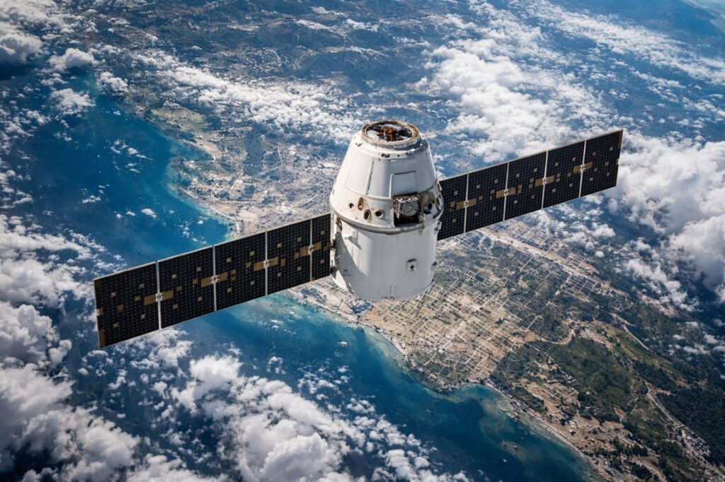
Figure 2 Earth observation satellite supporting GeoAI risk analysis.
GeoAI models are powered by diverse and complementary data sources.
Satellite and Climate Data
Satellite data are useful in providing large-scale and consistent coverage to monitor environmental conditions, such as land cover, vegetation, surface temperatures, and moisture.
Terrain and Vector Data
Terrain and vector data provide the spatial structure, including topography, rivers, infrastructure, and settlement patterns.
Ground-Based and Community Data
Ground-based data, such as rain gauges, disaster history, and community reports, provide the accuracy and local context that is often missing in satellite and terrain data.
Tools and Platforms Used in GeoAI Workflows
The development of GeoAI models can involve the integration of open-source software, cloud-based geospatial platforms, and artificial intelligence frameworks to handle large volumes of data, train models, and produce results that can be applied to real world decision making processes. Unlike traditional GIS models, GeoAI models are capable of continuously updating the models and generating results in real-time, as the data is being ingested.
Open-Source Tools for GeoAI Development
Open-source software is an important foundation, especially considering its flexibility, transparency, and cost-effectiveness.
GIS and Spatial Preprocessing Tools
Preprocessing geospatial data is an important initial process that often involves coordinate transformation, resampling, terrain analysis, and feature extraction, among others. This process significantly impacts the reliability of any model.
Python-Based Geospatial Libraries
The Python language facilitates the integration of GIS and AI modeling, which are crucial in developing GeoAI systems.
Machine Learning and AI Frameworks
AI frameworks are important in the development of GeoAI systems, especially considering their ability to train models and provide a platform for hyperparameter tuning and evaluation.
Cloud and Big-Data Platforms for GeoAI
Cloud computing platforms are important in addressing the large volume and high speed of disaster-related data.
Cloud-Based Geospatial Processing
Cloud computing facilitates the parallel processing of satellite images and the use of global datasets without any space constraints.
Near-Real-Time Data Ingestion
GeoAI systems are important in providing near-real-time data, which facilitates the monitoring of risks and the generation of early warnings.
APIs and System Integration
APIs are important in facilitating the integration of GeoAI systems into emergency management systems, which are often non-technical.
Visualization and Decision-Support Systems
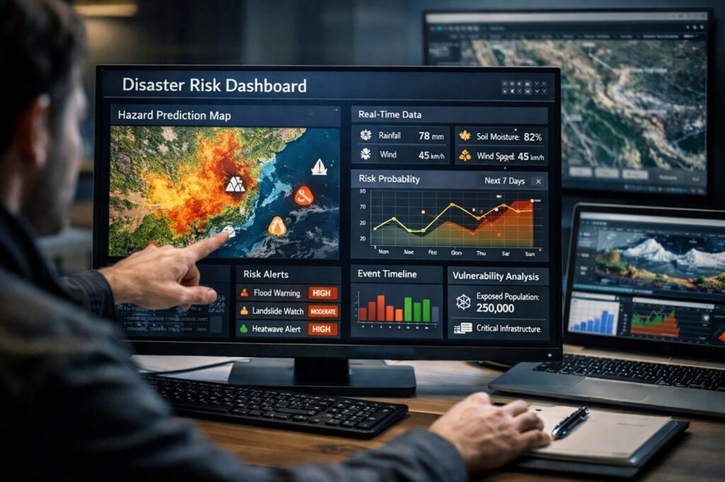
Figure 3 GeoAI decision-support dashboard for disaster risk monitoring.
GeoAI systems are best used when they are able to provide outputs that can be visualized and acted upon by decision-makers. Having effective predictive models is not enough; these models must also be communicated to decision-makers in an effective and efficient manner. Visualization and decision support systems provide effective communication of model outputs to decision-makers, hence improving disaster response and management.
One of the tools that can be used in decision support systems is a dashboard. This tool integrates different data streams, including real-time hazards, risk probabilities, and historical event data. GeoAI systems can also provide emergency managers with tools such as maps, time series, and charts that show changes in risk probability over time. These tools can be used by emergency managers to track changes in risk probability before, during, and after disaster events.
A well-designed dashboard can also help emergency managers understand complex data, allowing them to assess the situation, identify areas of concern, and take appropriate actions in critical times. This will ensure that insights gained from GeoAI systems can be acted upon.
Additionally, risk maps can also be used as tools of communication among stakeholders. Unlike other maps that show hazards, risk maps are dynamic, meaning that they can change as new data are introduced. These maps can also show probability, uncertainty, and impacts.
Web-based systems can also allow for information sharing across different agencies and geographical locations. This can help with better coordination and ensure consistency in information dissemination to the public. Access control can also ensure that critical information is only accessible to authorized personnel. Therefore, these systems can enhance preparedness and awareness in the community.
GeoAI systems can also enhance early warning systems. In this case, the predictive model can send alerts to the relevant authorities and the community once it recognizes that certain thresholds have been reached. The generation of alerts can enhance preparedness and response to different situations. In addition, the generation of alerts can also enhance preparedness and response to different situations.
Operationalizing GeoAI: From Research to Real-World Application
For real world application of GeoAI systems, it is essential to ensure that the systems can effectively operate in different situations. We need to ensure that the systems can handle incomplete data and also work during extreme events.
GeoAI systems can also require continuous model maintenance. In this case, different climatic changes, land use, and infrastructural changes can influence the effectiveness of these systems. Hence, it is essential that these systems can be updated regularly to enhance effectiveness. In addition, the effectiveness of the model can also reduce over time. In this case, it is essential to ensure that the model is monitored and evaluated regularly to ensure effectiveness. Cloud-based infrastructures can also increase the effectiveness of these systems.
Institutional capacity is also equally important. Organizations must build technical expertise, data governance, and clear decision protocols to act on the outputs generated by GeoAI systems. Additionally, personnel must be trained to understand the potential and capabilities of GeoAI systems. This will help in preventing confusion during emergency situations. Training programs must be conducted to ensure users understand what GeoAI systems can and cannot do, to promote appropriate expectations and use of GeoAI outputs.
Another important aspect of GeoAI implementation is interdisciplinary collaboration. Data scientists, geospatial analysts, meteorologists, engineers, disaster management experts, and policymakers must work together to develop models and ensure they are aligned to operational and policy needs. When technical and institutional context are combined in GeoAI systems, they become both technically and practically effective, making them easily integrable into existing disaster management systems and frameworks.
Case Study: Application of GeoAI in Flood Risk Management
In the context of a rapidly developing river basin, traditional flood maps were found to be obsolete due to changing land use and urbanization. To manage this, a GeoAI system was developed to integrate rainfall data, land use changes, and terrain models to generate daily flood probability maps. This approach has helped in better management of flood risks and has become an important tool for effective flood management in the region. This case study demonstrates the application and potential of GeoAI in effective and efficient flood risk management and monitoring.
Governance, Ethics, and Responsible Use of GeoAI
With the growing impact of GeoAI on disaster-related decisions, ethics, and governance become essential. The system must be implemented transparently, fairly, and responsibly. Some of the key concerns to be addressed include issues of bias, fairness, accountability, and the ability to communicate uncertainty, to enable all communities, especially those at higher risk of disaster, to benefit from GeoAI.
The Future of GeoAI in Disaster Risk Governance
GeoAI has transformed the way institutions tackle disaster risk management. It has become instrumental in ensuring institutions plan proactively, develop risk-informed infrastructure, and inform policy-making. Climate change has enhanced disaster risks, making predictive systems more central to disaster risk management. GeoAI has the potential to make a significant impact on disaster risk management, especially with regard to building resilience and long-term risk reduction strategies.
Conclusion: Building a Predictive Culture of Preparedness
Disasters do not occur by chance. Instead, they have been constant risks, which have become worse due to climate change and anthropogenic activities. GeoAI has the ability to change the paradigm from reactive responses to proactive risk anticipation, mitigation, and prevention. The system has the ability to predict with greater accuracy the risks of disasters by analyzing spatial, environmental, and dynamic patterns. GeoAI systems can enable societies to stay one step ahead of emerging risks.