GIS mapping services exist for one reason: because data without insight is just noise. Every organization reaches a moment when the maps, spreadsheets, and reports stop being useful. Not because the data is wrong, but because nothing is connecting it into a decision anyone can actually act on. A planner still doesn’t know where to build. The government still can’t see where disaster risk is concentrated. A business still has no clear picture of where to expand.
Simply put, GIS mapping services transform geographic data into actionable intelligence, helping organizations visualize patterns, analyze spatial relationships, and make data-driven decisions with greater accuracy and confidence.
That gap between data and decision is exactly where professional GIS mapping services step in, and in 2026, what they are capable of delivering would have seemed almost impossible just a decade ago.
This isn’t a guide to GIS software. This is a guide to what GIS mapping services actually do, why they matter across every industry that relies on location-based intelligence, and how organizations can use them to make faster, smarter, and more confident decisions. For a deeper understanding of how GIS specialists use geospatial data to solve real-world problems, the applications go far beyond what most people expect.
What GIS Mapping Services Actually Mean
Geographic Information Systems have been used for mapping since the 1960s, but the term “GIS mapping services” now refers to something far more powerful than it did even five years ago. At its core, a GIS mapping service takes spatial data, information tied to specific locations on the Earth’s surface, and transforms it into visual, analytical, and predictive intelligence that organizations can act on.
It involves the collection and analysis of satellite images, the development of interactive dashboards, the generation of thematic maps for strategic planning and policy development, land use and environmental change analysis, flood risk modeling, and infrastructure vulnerability assessments, as well as the integration of real-time data feeds into decision-making systems. The word “services” is important here. Unlike GIS software, which provides tools for organizations to use themselves, GIS mapping services deliver ready-to-use intelligence, analysis, and recommendations from specialists who understand both the technology and the domain it serves.
The global GIS market was valued at over $14 billion in 2025 and is projected to nearly double by 2031. That growth is not driven by organizations buying more software; it is driven by the recognition that spatial intelligence, delivered as a service by specialists, creates competitive and operational advantages that no amount of in-house tool adoption can fully replicate.
The 7 Core GIS Mapping Services That Deliver Real Results
1. Geospatial Data Production
The use of data plays an essential role in every GIS application; therefore, the better quality of data utilized means the better quality of insights generated from it. Professional geospatial data production services go far beyond simply collecting coordinates. These processes entail the analysis of satellite images, classification of land-use types, creation of infrastructure databases, and creation of decision-support systems databases.
There exists a clear distinction between the production of high-quality geospatial data and merely collecting raw data. Well-structured data provides faster processing, increased accuracy, and improved decision-making. Poorly structured data leads to confusion, mistakes, and errors at every step of the way after that.
2. Remote Sensing and Satellite Image Analytics
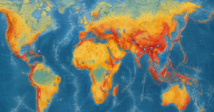
The use of satellite imagery is a very powerful source of information that can be analyzed; however, it is one of the least utilized sources. Satellite pictures would mean nothing without proper processing by specialists. Professional remote sensing and image analytics services apply machine learning models and spectral analysis techniques to extract meaningful intelligence from multispectral and hyperspectral imagery.
Applications range from detecting crop stress and vegetation health for agricultural planning to monitoring urban expansion, identifying illegal construction on protected land, mapping post-disaster damage extents, and tracking changes in glacier coverage and coastal erosion over time. These are not theoretical applications; they are operational realities for governments, NGOs, and development organizations working in environments where ground-level access is limited or impossible.
3. Spatial Databases and Web GIS Platforms
Some of the most practical and yet ignored GIS mapping services include designing and implementing a spatial database and web GIS platforms. Even if an organization has all the right tools and expertise for conducting analysis, having information contained in isolated spreadsheet files does not maximize the utility of the intelligence obtained from the data.
Designing a spatial database involves structuring the geospatial information and making it available in real time for multiple users and compatible with other data sources within the organization. In addition, developing a web GIS makes it possible for people who do not specialize in GIS to interact with the spatial data and conduct analysis. For an in-depth look at how AI is transforming GIS and remote sensing applications, the integration of intelligent systems into these workflows is accelerating rapidly.
4. Decision Support and Applied GIS Solutions

Perhaps the most directly valuable GIS mapping service for organizations in high-stakes environments is decision support through applied GIS solutions. This means building spatial systems that do not just display information, they help answer specific operational questions with analytical precision.
Which areas face the highest risk of flooding in the next 24 hours? Where should a new health facility be located to maximize coverage for underserved communities? Which infrastructure assets are most vulnerable to earthquake damage? What is the optimal evacuation route given current road conditions and population distribution? These are the kinds of questions that well-designed GIS decision support systems can answer in near real time, and the answers they provide save lives, reduce costs, and improve outcomes in measurable ways. Our MHVRA Muzaffarabad disaster risk tool is a working example of decision support GIS applied to real disaster management challenges.
5. Mapping, Cartography, and Visualization
Professional mapping, cartography, and visualization services are responsible for transforming complex spatial datasets into maps and visual products that communicate clearly to technical and non-technical audiences alike. This involves much more than the creation of a simple map featuring legends and a scale.
A professional cartographer specializes in the creation of thematic maps that illuminate hidden patterns in the data, developing user-friendly dashboards for filtering and analyzing spatial data according to sector, period of time, or geographic units, as well as delivering publication-quality maps for use in policy reports, project applications, and media and communication strategies. “The key to making good maps lies in telling a story.”
6. Predictive Modeling and AI-Powered Analysis

The most transformative development in GIS mapping services over the past several years is the integration of artificial intelligence and machine learning into spatial analysis workflows. Predictive modeling and AI development applied to geospatial data enable organizations to move from describing what has happened to forecasting what will happen next.
Flood extent prediction, infrastructure degradation modeling, wildfire risk forecasting, urban growth simulation, and crop yield estimation are all examples of AI-powered geospatial analysis that are now operational rather than experimental. Organizations that adopt these capabilities gain a genuine planning advantage, the ability to anticipate challenges and allocate resources before problems escalate, rather than responding after the fact. For organizations interested in understanding how GeoAI is changing disaster risk prediction, the methods and tools available today are more accessible than ever.
7. GIS Consultancy and Capacity Building
Not every organization needs a full-service geospatial intelligence deployment. Many need strategic guidance, help understanding what GIS mapping services are most relevant to their specific challenges, how to structure a spatial data infrastructure that will serve their needs over time, and how to build internal capacity to maintain and evolve their GIS capabilities. Professional GIS consultancy services address exactly this need.
Good GIS consultancy goes beyond recommending software. It involves understanding organizational objectives, mapping current data assets and gaps, designing workflows that fit existing capacity, and providing training and advisory support that builds genuine long-term capability rather than dependence on external providers.
Who Needs Professional GIS Mapping Services
The answer is broader than most people realize. Government departments at the national and local levels use GIS mapping services for urban planning, infrastructure management, preparing for disasters, enforcing environmental laws, and tracking the spread of diseases. International development organizations and NGOs use spatial services to plan interventions, monitor program outcomes, and demonstrate impact to funders. Businesses in real estate, transportation, agriculture, insurance, and energy employ GIS technology for logistical purposes, risk management, and identifying potential a preparing for disasters, enforcing environmental laws, and tracking the spread of diseases. Reasons for expansion. For organizations working on climate change adaptation and sustainability challenges, spatial intelligence has become an essential component of every evidence-based strategy.
What Separates Genuinely Powerful GIS Mapping Services
Not all GIS mapping services deliver equal results. The organizations that get the most value from their spatial intelligence investments share three characteristics. First, they work with providers who understand their domain, the specific sectors, challenges, and decision contexts in which GIS data will be used. A geospatial specialist who understands disaster management will produce different and more useful outputs than one who approaches the work as a purely technical exercise. Second, they invest in data quality from the start. The quality of every analysis, model, and visualization depends directly on the quality of the underlying spatial data. Shortcuts in data production create errors that compound across every subsequent step. Third, they connect spatial intelligence to actual decisions. Maps and dashboards that do not change behavior or inform choices are expensive decorations. The best GIS mapping services are designed around specific decisions that need to be made, not around the technical capabilities that happen to be available. Explore our full range of AI-powered GIS and geospatial solutions to see how these principles are applied in practice.
Conclusion
GIS mapping services have moved far beyond the creation of static maps. These technologies have become a cornerstone of more intelligent planning, quicker reaction, and decision-making in all industries where insight into geographic space is required, which, in the year 2026, is all industries that matter. The organizations that are committing to GIS professional mapping services right now are laying down the analytical groundwork that will determine their success in the coming decade.
Geospatial data creation, satellite imagery analysis, predictive modeling, and GIS consulting are among the services offered by GIS professional mapping companies, but even before considering any of these, one should ask if GIS is relevant to your business. To better understand its impact, explore our detailed guide on How Climate Intelligence Can Improve Agricultural Planning in Pakistan?.
The real question is how much value you are currently leaving on the table by operating without it. Contact our team to explore how professional GIS mapping services can transform your organization’s decision-making from reactive to genuinely proactive.
Frequently Asked Questions
Q1: What are GIS mapping services?
GIS mapping services are specialized services offered by experts who perform the collection, processing, analysis, and visualization of spatial information to generate useful intelligence. While GIS software refers to software that can be utilized by businesses alone, GIS mapping services are provided by experts within their respective fields.
Q2: How are GIS mapping services different from Google Maps?
Google Maps is a navigation and consumer mapping tool. Professional GIS mapping services involve deep spatial analysis, custom data production, predictive modeling, and decision support, built for government agencies, enterprises, NGOs, and research institutions with complex operational needs that navigation tools are not designed to address.
Q3: Which industries use GIS mapping services the most?
All government organizations, public sector organizations, urban planning offices, disaster management departments, environmental agencies, agricultural bodies, international development NGOs, infrastructure builders, property developers, and climate change institutes depend significantly upon GIS mapping services in their daily activities.
Q4: How does AI improve GIS mapping services?
AI enables automated feature extraction from satellite imagery, predictive spatial modeling, real-time data processing, and pattern detection at scales that manual analysis cannot match. The result is faster insights, higher accuracy, and the ability to forecast future conditions rather than simply describing current ones.
Q5: What is the difference between GIS mapping services and remote sensing?
Remote sensing is a specific data collection method that uses satellite or aerial imagery to gather spatial data. GIS mapping services encompass a much broader range of activities, including data production, spatial analysis, cartographic design, decision support system development, and consultancy, of which remote sensing is one important input.
Q6: How long does it take to see results from GIS mapping services?
This depends on the scope of the engagement. A targeted spatial analysis or thematic mapping project can deliver outputs within days to weeks. A full decision support system deployment or geospatial data infrastructure project typically takes months and delivers value over years.
Q7: Can GIS mapping services support ESG and sustainability reporting?
Yes. Satellite-based monitoring of land use, forest cover, water resources, and emissions provides the spatially verified evidence that credible ESG reporting requires. Learn more about how our ESG consulting services integrate geospatial intelligence into sustainability frameworks, and explore our ESG Carbon Emission tracking tool for a practical example of spatial ESG monitoring in action.