Where intelligent maps meet bold ideas, crafted with precision, driven by process and built for what’s next.
Ai Geo Navigators combines the predictive power of Al with the precision of Geospatial Intelligence to help organizations not just report on climate change, but actively plan for and build resilience against it.
Flood, drought, heatwave, and multi hazard risk assessment. Early warning systems and disaster risk reduction solutions for climate resilience.
Dashboards, digital twins, simulations, and planning tools that support operational, policy, and investment decisions.
Flood, drought, heatwave, and multi hazard risk assessment. Early warning systems and disaster risk reduction solutions for climate resilience.
Machine and deep learning integrated with GIS, remote sensing, and traditional analytics to convert climate and environmental data into actionable intelligence.
AI-powered infrastructure management for urban mobility, public services, resource distribution, smart grids, and waste management.
Climate mitigation and adaptation analytics, ESG indicators, sustainability performance tracking, and disclosure reporting for institutions and companies.
Strategy, policy advisory, system implementation, environmental communication, PR, advocacy, and professional training.
We Map Data and Business Solution!
We provide solutions for climate adaptation and disaster risk reduction, including hazard mapping and early-warning systems.
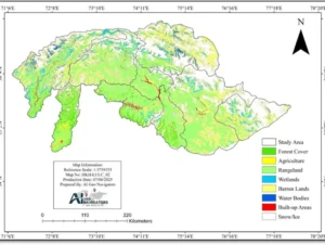
We analyze satellite and drone imagery to provide actionable insights for environmental monitoring, land use planning, and disaster assessment.
We design interactive, web-based GIS dashboards that allow real-time data monitoring and visualization.
We streamline spatial data management by integrating diverse geospatial datasets into a single cohesive platform.
We offer expert geospatial consulting services, delivering custom solutions that address unique client needs.
We strengthen client capabilities through training, workshops, and skill development in GIS, remote sensing, and climate resilience.
We deliver innovative, long-term solutions that mitigate climate change impacts, focusing on sustainability and environmental preservation.
We help clients align their operations with ESG principles, ensuring sustainable practices in environmental protection, social responsibility, and ethical governance.
Flood, drought, heatwave, and multi hazard risk assessment. Early warning systems and disaster risk reduction solutions for climate resilience.
Dashboards, digital twins, simulations, and planning tools that support operational, policy, and investment decisions.
Flood, drought, heatwave, and multi hazard risk assessment. Early warning systems and disaster risk reduction solutions for climate resilience.
Machine and deep learning integrated with GIS, remote sensing, and traditional analytics to convert climate and environmental data into actionable intelligence.
Climate mitigation and adaptation analytics, ESG indicators, sustainability performance tracking, and disclosure reporting for institutions and companies.
Strategy, policy advisory, system implementation, environmental communication, PR, advocacy, and professional training.


A transformative platform that integrates the power of satellite data, AI, and advanced machine learning to deliver actionable insights for the world’s most pressing environmental challenges.

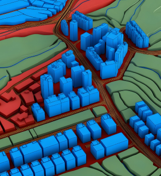
RESLI AI is a cutting-edge, AI-driven decision engine designed to tackle the challenges of urban resilience in the face of rapid urbanization and intensifying climate stress. By integrating dynamic, parcel-level data and predictive models, RESLI AI empowers cities to shift from reactive crisis management to proactive, strategic planning. This innovative tool helps urban planners make smarter, data-backed decisions, ensuring that resources are allocated effectively to prevent future failures and build more resilient urban environments.
A transformative platform that integrates the power of satellite data, AI, and advanced machine learning to deliver actionable insights for the world’s most pressing environmental challenges.
A transformative platform that integrates the power of satellite data, AI, and advanced machine learning to deliver actionable insights for the world’s most pressing environmental challenges.
EXCELLENTTrustindex verifies that the original source of the review is Google. AI Geo Navigators is a great company for GIS and remote sensing services. Their team is supportive, professional, and quick to respond. A great choice for anyone looking for reliable and effective geospatial solutions.Posted onTrustindex verifies that the original source of the review is Google. Excellent experience with AI Geo Navigators! Team is knowledgeable and responsive. Highly recommend for mapping and navigation solutions.Posted onTrustindex verifies that the original source of the review is Google. Great experience at Ai geo navigators. The team is professional, knowledgeable and very helpful.Posted onTrustindex verifies that the original source of the review is Google. Great experience at AI Geo Navigators Pvt Ltd. The team is professional, knowledgeable, and very helpful. Their expertise in GIS and geospatial solutions is top-notch. Convenient location in I-8/4 Islamabad. Highly recommended!Posted onTrustindex verifies that the original source of the review is Google. It's very goodVerified by TrustindexTrustindex verified badge is the Universal Symbol of Trust. Only the greatest companies can get the verified badge who has a review score above 4.5, based on customer reviews over the past 12 months. Read more