- Introduction
Gilgit-Baltistan (GB) is one of the most fragile and climate-sensitive mountain areas in the world. It sits at the meeting point of the Karakoram, Hindu Kush, and western Himalayas. This region is home to some of the largest glaciers outside the polar regions, including parts of the extensive Karakoram ice fields. These glaciers supply water to the Upper Indus Basin, helping millions of people downstream in Pakistan and playing a vital role in the country’s freshwater supply.
The region extends over an area of approximately 72,000+ square kilometers, of which much of it is mountainous terrain above 2,000 meters in elevation, including several peaks above 7,000 meters in elevation. GB is also home to some of the highest relief landscapes in the world, including K2 and other major peaks. These all significantly contribute to regional climate systems. Over 13,000 glaciers exist in the greater Karakoram-Himalaya region, of which there is a significant concentration in GB. These glaciers act as water towers, providing water during the summer by storing winter snowfall.
More than 70% of the human population of GB resides in the rural areas, and the livelihood of the people is heavily dependent on climate-sensitive sectors like subsistence farming, grazing, forestry, and small-scale commerce. Conventional irrigation systems are dependent almost entirely on the predictable glacial meltwater flow. Disruption of the predictable flow of meltwater directly impacts crop yield.
A combination of climate change and deforestation is intensifying natural risks such as flash floods, landslides, avalanches, and Glacial Lake Outburst Floods (GLOFs). Several extreme events have affected infrastructure such as roads, bridges, agricultural lands, and hydropower infrastructure in the region during past decades. The region has narrow valleys and steeper slopes along with settlements along riverbanks.
Moreover, the isolated location of GB also makes disaster response and recovery more difficult. The affected populations may not have access to early warning systems, insurance, or alternative livelihood strategies, making them more vulnerable.
In view of the above, environmental change in Gilgit-Baltistan is not only an environmental problem, but it has also assumed the character of a complex development problem. It has implications for water, food, infrastructure, biodiversity, and development. The complex relationship between climate change, forest cover, and risk is critical for understanding the problem of environmental change in Gilgit-Baltistan.
2. Environmental Change in Gilgit-Baltistan?
Environmental changes are understood as changes in the functioning of the climate system, land surfaces, the water cycle, soil stability, and the functioning of ecosystems in general. Environmental changes are particularly important in mountainous regions such as Gilgit-Baltistan, as the environmental system is very sensitive to any changes in the climate. The altitude, steepness, and glaciated nature of Gilgit-Baltistan make the environment very sensitive to environmental pressures.
In GB, two major forces dominate environmental transformation:
2.1. Climate Change Altering Temperature and Precipitation Patterns
Scientific observations suggest that high-altitude regions are experiencing an increase in temperature levels above the average. The increase in temperature levels in GB is resulting in:
• Faster glacier melting
• Diminishing snowfall in lower regions
• Sooner start of spring season
• More frequent short-duration high-intensity rainfalls
• More climate variability and season unpredictability
These temperature changes disrupt the balance of nature in terms of snowfall and water discharge. The glaciers that were discharging water slowly during summer months are now showing signs of unusual discharge. While there is stability in some regions of Karakoram, referred to as the ‘Karakoram Anomaly,’ other glaciers in these regions are showing signs of retreat.
Changes in Precipitation
Changes in precipitation levels in these regions are also significant. While there was once consistent snowfall and moderate rain in these regions, there is now an increase in irregular rainfall in these regions. Intensity in rainfall is resulting in increased surface runoff in these regions due to diminishing vegetation.
Climate change also impacts evapotranspiration rates, soil moisture levels, and agricultural productivity. While it is true that warmer temperatures can extend the growing season in some regions, it is also true that it can increase pest problems and water stress in crops.
2.2. Land Use Change Especially Deforestation and Land Degradation
Land use changes in GB are mainly due to factors like population growth, infrastructure development, fuelwood dependency, and the expansion of agricultural land. Even though the forest cover in GB is less in comparison to other parts of Pakistan, any reduction in vegetation cover can have major effects on the mountain environment.
The major causes of land degradation are:
•Unsustainable fuelwood collection
•Timber logging
•Overgrazing of livestock on slopes
•Cutting of slopes for road development and extension of settlements on marginal lands
Vegetation cover is important in maintaining the stability of slopes. The plant roots hold the soil particles together and prevent erosion. During the loss of vegetation cover in the area:
• There is increased surface runoff on the slopes.
• Soil erosion increases.
• The sediment load in the rivers increases.
• Slope failures are common.
The loss of vegetation cover also changes the microclimatic conditions in the area. The microclimate in the area is maintained by the vegetation cover. During the loss of vegetation cover, the microclimate changes, and the soil tends to heat up.
2.3. Interaction Between Climate Change and Land Use Change
Climate change and deforestation do not occur in isolation. Instead, there is an interaction between these two factors that further aggravates the instability of the environment. For instance:
• Increased rainfall combined with deforested slopes leads to severe landslides
- Rapidly melting glaciers accompanied by rivers loaded with sediment cause flooding.
- The loss of forests contributes to increased levels of carbon dioxide in the atmosphere.
The combined effect of these factors contributes to instability in the environment. For instance, in mountainous regions such as GB, even small disturbances in the environment can cause major disasters. Therefore, it is critical to consider GB as vulnerable to compound risks of climatic change.
Environmental change in Gilgit-Baltistan is a complex process that is driven by various factors, including global climatic changes as well as local land use practices.
2.4. Climate Change: Hotter, Wetter, More Variable
The Karakoram and Himalayan regions are witnessing a change in the climate, which is a manifestation of the global warming phenomenon. The region is witnessing a rise in temperature, making it generally hotter and wetter, with more variable weather patterns. Scientific research has indicated the following changes:
• Increased mean annual temperatures
• Early snow melt
• Increased extreme precipitation events
Graph 1: Temperature Trend (1980–2025, Gilgit-Baltistan)
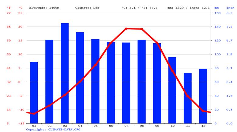
Fig 1: Observed warming trends in Gilgit-Baltistan and the broader Himalaya region
These trends accelerate glacier retreat, increase glacial lake expansion, and affect seasonal water availability. Temperature rise also shifts vegetation zones, affecting forests and rangelands.
3. Deforestation: Loss of Natural Protection
The forests of Gilgit-Baltistan are naturally restricted due to high altitude, steep slopes, and extreme climatic conditions. The natural vegetation consists of shrub lands, community woodlots, and narrow strips of riverine forests. These provide vital ecosystem services. However, these forests are facing pressure due to human activities like wood harvesting for firewood and construction materials, overgrazing by livestock, and conversion of forestland into agricultural and settlement areas. This loss of natural protection causes landslides and floods due to decreased slope stability, reduction of soil retention capacity, and increased surface runoff during heavy rainfall. In addition to natural protection, forests of Gilgit-Baltistan are important for microclimate regulation, maintenance of biodiversity, and carbon storage. Any reduction in forest cover can have significant consequences for environmental stability and the people who rely on these forests for their livelihood.
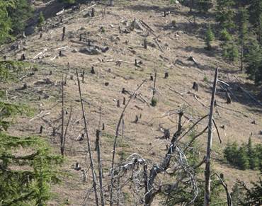
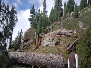
Fig 3: Visual signs of forest loss in GB
While forest loss in GB is less than lowland regions, even small changes can affect slope stability, soil retention, and microclimate, especially in steep valleys.
4. How Climate & Deforestation Drive Hazards
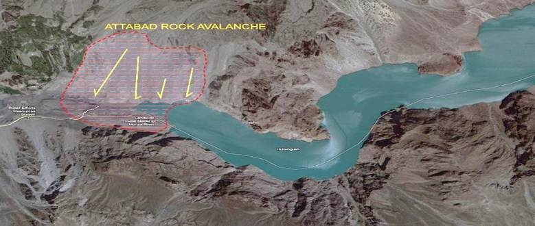
Environmental changes in Gilgit-Baltistan do not happen in isolation, and they have a direct impact on natural hazards. One of the most prominent natural hazards in Gilgit-Baltistan is Glacial Lake Outburst Floods (GLOFs). With rising global temperatures, glaciers in Gilgit-Baltistan and other cold-climate regions around the world are melting at a rapid pace. Glaciers melt and form lakes, and these lakes are often dammed either by ice or moraine. The ice dam is highly unstable and often breaks, especially during periods of heavy rainfall, rapid snowmelt, or earthquakes, causing GLOFs. GLOFs have the capability to destroy infrastructure, residential areas, agricultural land, and livestock within minutes. GLOFs often leave no time for early warning and evacuation. GLOFs are more likely to happen in areas that have been deforested or degraded, and this increases the damage caused by GLOFs. Over the last few decades, GLOFs in Gilgit-Baltistan have caused immense economic and social losses.
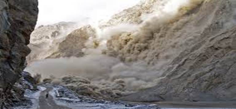
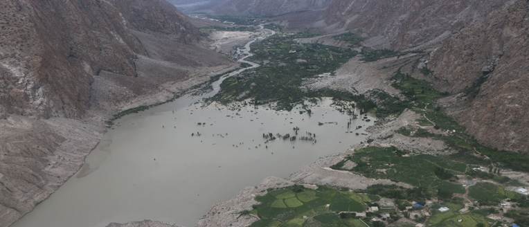
Fig 4: Glacial lake hazards including historical landslide like Attabad (2010)
5.Flash Floods & Debris Flows
Extreme rainfall events, which are becoming more common and intense in the region due to the effects of climate change, are the major cause of flash floods and debris flows in Gilgit-Baltistan. Flash floods are sudden flows of water, soil, and rocks in the valleys of Gilgit-Baltistan. They are particularly dangerous in the valleys of the region due to the steep and narrow valleys through which the rivers and streams flow. Flash floods are particularly dangerous in the valleys of Gilgit-Baltistan due to the sparse vegetation in the region. Flash floods can cause extensive damage to the infrastructure of the region in the shortest time. Flash floods can cause damage to the roads, bridges, irrigation channels, and homes in the shortest time. Flash floods and debris flows also cause extensive damage to the water reservoirs of the region due to the increased sediments in the rivers of the region.
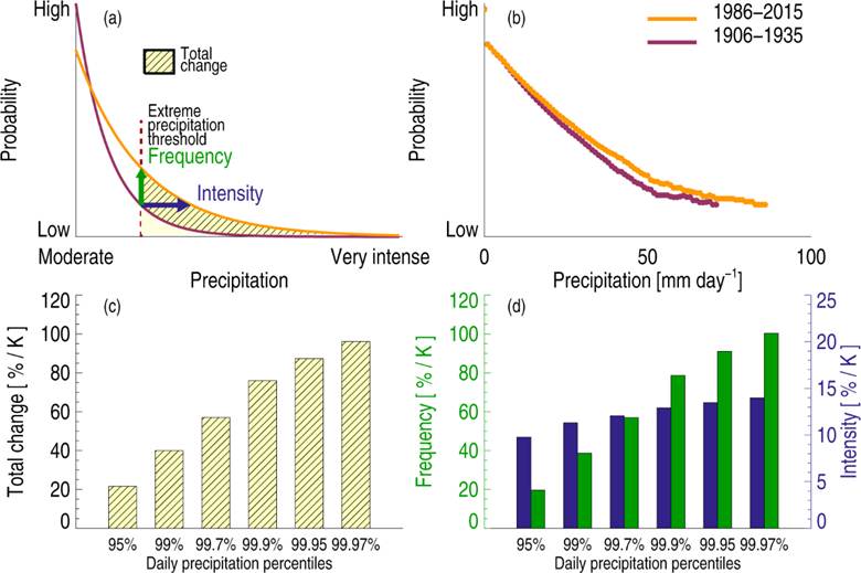
Fig 5: Trends toward heavier rainfall events in the broader Himalayan region
6. Landslides
Landslides are one of the most common hazards in Gilgit-Baltistan, and the main reason for the occurrence of such hazards is the steep and rugged terrain of the area. Landslides are also caused by excessive rain, rapid melting of snow, and seismic activities. However, human activities such as deforestation also contribute to the susceptibility of the area to such hazards. The presence of vegetation cover on the surface of the earth, such as the roots of plants, holds the earth firmly in place. However, the removal of the vegetation cover due to excessive deforestation, overgrazing, or the development of agricultural land increases the susceptibility of the area to such hazards. Landslides are also responsible for the increase in the amount of sediment load in the river, which further increases the severity of the flood hazard.
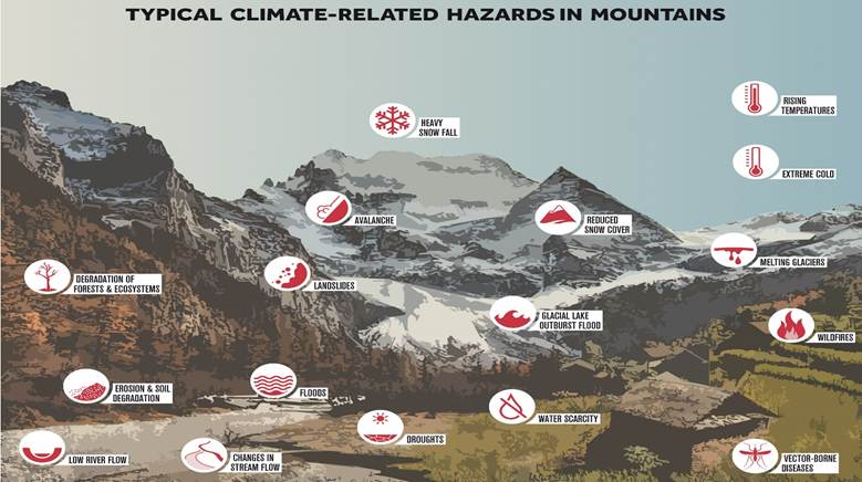
Fig 7: Hypothetical depiction of communities in hazard-prone zones
7. Community Risk in GB
The communities in Gilgit-Baltistan are at great risk due to the occurrence of natural disasters like floods, landslides, and debris flows. The major effects of these disasters on the communities in the region include the interruption of agriculture, destruction of roads and homes, loss of pastureland, water scarcity, and health risks due to dust and water pollution. The communities are vulnerable due to the occurrence of these disasters and the environmental factors in the region. This makes the community risk in Gilgit-Baltistan a major factor of concern.
What Communities Face
• Disrupted agriculture due to water variability
• Damage to roads, houses, irrigation systems
• Loss of pastureland
• Water scarcity in dry seasons
• Health risks due to dust, vector changes, water pollution
Fig 6: Mountain communities, infrastructure and disaster impacts
- Why Deforestation Matters
Even the limited forests in Gilgit-Baltistan provide critical ecological services. Tree roots anchor soil, reducing landslide risk; vegetation enhances water infiltration, limiting surface runoff; forests store carbon, helping mitigate climate change; and they provide habitat for local biodiversity. When these forests are lost, runoff increases, soil erosion accelerates, and flood peaks rise, amplifying the impacts of climate-driven hazards such as flash floods and landslides. In a mountainous region like GB, even small reductions in forest cover can have cascading effects on slope stability, water systems, and community safety.
- Adaptation & Community Strategies
Although the risks are serious, local solutions exist. Some examples include:
9.1. Sustainable Forestry & Agroforestry
Although environmental risks in Gilgit-Baltistan are significant, local communities have implemented practical solutions to reduce vulnerability. Sustainable forestry and agroforestry practices such as community planting of native shrubs, establishing forest protection committees, and practicing controlled grazing help stabilize slopes, prevent soil erosion, and restore local microclimates. These measures not only reduce the risk of landslides and floods but also support biodiversity and enhance the long-term sustainability of agricultural and pastoral livelihoods in the region.
9.2. Early Warning Systems (EWS)
Rain gauges, river level sensors, and SMS-based EWS enable local populations to prepare for:
- Flash floods
- Landslide triggers
- Surges due to rapid snowmelt
9.3. Community Risk Mapping
Community risk mapping allows local populations to become active participants in managing natural hazards by providing them with the power to identify potential hazards in their regions. This includes floodplains, landslide-prone regions, and glacial lake regions. This approach to risk management is not only useful in raising public awareness about natural hazards but also helps in making appropriate decisions regarding land use and infrastructure development.
10.Policy & Institutional Framework
To manage the issue of environmental change in Gilgit-Baltistan, the government has to adopt a multi-level policy framework.
• Local councils are responsible for land management, ensuring that no settlement or development takes place in hazardous zones.
• Regional climate action plans help to formulate adaptation strategies, while national-level disaster management organizations provide funding and technical support for the mitigation of disasters.
• The use of GIS and remote sensing helps to improve decision-making, as it enables the authorities to locate hazardous zones, track changes in the environment, and formulate strategies to tackle the problem.
11.Case Studies
Case 1 – Attabad Lake Disaster (2010)
In January 2010, a massive landslide occurred in the Hunza Valley, which blocked the Hunza River, creating a lake that covered a large portion of the roads, settlements, and agricultural lands. The sudden formation of the lake resulted in the isolation of the settlements for a while, disruption of the trade activities, and the evacuation of thousands of people from the region. The Attabad Lake Disaster emphasizes the importance of continuous monitoring of the slopes, especially in mountainous regions, to avoid the occurrence of disasters like the sudden formation of a lake, which can isolate the settlements and disrupt the activities of the people living in the region. The documentation of the Attabad Lake Disaster, including the satellite images of the formation of the lake, the pictures of the villages covered by the lake, and the maps of the region, can play a crucial role in the mitigation of the disaster in the region.
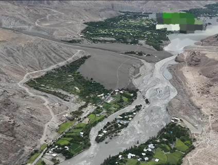
Case 2: The 2025 Talidas Flood in Ghizer District
The village of Talidas in the Gupis Valley of the Ghizer District in Gilgit-Baltistan was hit by a catastrophic Glacial Lake Outburst Flood (GLOF) on August 22, 2025. This case highlights the potential hazards of climate change in high-altitude regions. Severe heatwaves had caused accelerated glacial melt in the upper catchment area. This had created a precarious glacial lake. At the beginning of the morning, the natural moraine dam of the glacial lake burst, causing a massive flood wave to flow downstream.
The flood was catastrophic and caused significant damage to infrastructure. The flood destroyed 180-200 houses, damaged roads and schools, washed away irrigation channels, and flooded agricultural land. Over 3,000 people were displaced due to the flood. This was the second-largest internal displacement in the region since the Attabad Lake disaster in 2010.
- Conclusion
Environmental change in Gilgit-Baltistan is not an abstract concern but one that is currently unfolding and transforming the region’s environment and human life. Increases in temperature, glacier melt rate, and precipitation patterns, along with deforestation, are all interacting to increase the magnitude and frequency of environmental hazards such as flash flooding, landslides, and Glacial Lake Outburst Floods (GLOFs). This demonstrates that Gilgit-Baltistan is extremely vulnerable to climate-related disasters.
However, the experiences of communities in places like Attabad, Upper Gilgit, and Talidas show that risks can be minimized by working together with the communities, science, and policy. Communities can be made to respond to risks by engaging in activities like community engagement, science-based monitoring, policy and institutional support, and sustainable land use, which can help the communities to respond to risks more effectively. Scientific monitoring of the region, including the use of tools like remote sensing, GIS, and climate change, can provide information about the risks faced by the region, which can help in planning for the risks. Sustainable land use can help in maintaining stability in the region, which can help the region to respond to risks more effectively.
Together, all these strategies form an integral plan for mitigating vulnerability and enhancing resilience in Gilgit-Baltistan. Despite all the challenges that come with climate change and deforestation, all these strategies can ensure that Gilgit-Baltistan is secure and its environment is sustainable for future generations. The experiences gained from past disasters show that being prepared and adaptable is not only important but necessary for Gilgit-Baltistan’s future.