Table of Contents
ToggleBackground:
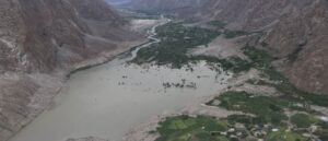
The mountainous regions of Pakistan, particularly Gilgit-Baltistan, Swat, and Chitral, are highly vulnerable to landslides, flash floods, seismic activity, glacial lake outburst floods (GLOF), and other climaterelated hazards. Rugged terrain, fragile geology, and increasing climate variability amplify risks to lives, infrastructure, and ecosystems. Unplanned housing expansion on steep slopes, riverbanks, or high-risk areas further exposes communities, already imperiled by land scarcity, limited awareness, and poor access to spatial data.
Case summary:
The project uses geo-spatial technologies to identify safe, sustainable, and disaster-resilient housing sites in Pakistan’s mountainous regions. High-resolution satellite and drone imagery, combined with Geographic Information System (GIS) and Remote Sensing, can divert housing development away from hazard-prone areas. Digital elevation models, landslide susceptibility maps, floodplain and river buffer zones, seismic fault lines, historical disaster records, and rainfall patterns are overlaid with socio-economic and infrastructure data to assess safe settlement zones.
Findings are validated through field surveys and local stakeholder engagement to ensure accuracy and relevance. A key feature is the integration of Indigenous knowledge, which ensures housing designs meet safety standards, remain culturally appropriate, and are affordable. This approach aligns with global frameworks such as the Sendai Framework for Disaster Risk Reduction, Sustainable Cities and Communities and Climate Action, providing a replicable model for hazard-informed, context appropriate and resilient housing planning.
Published by
International Centre for Integrated Mountain Development, GPO Box 3226, Kathmandu, Nepal
Editing
Sunipa Das Gupta, ICIMOD
Layout and cover design
Sudip Kumar Maharjan, ICIMOD
Photos used in this document are courtesy of the case authors, unless otherwise specified.