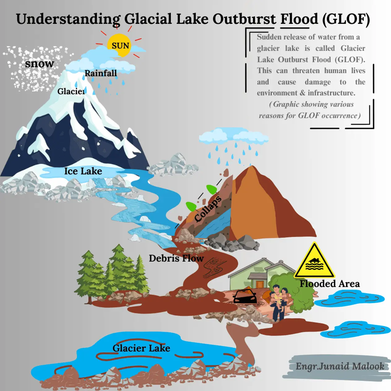
Glacial Lake Outburst Floods (GLOF) happen when a glacial lake suddenly bursts and releases a huge amount of water. This usually occurs when the natural walls holding the lake made of ice, rocks, or loose soil break down. These floods are among the most dangerous disasters in mountain areas like the Himalayas, Karakoram, Hindu Kush, Andes, and the Alps.
Because of global warming, glaciers are melting faster, and more lakes are forming, which increases the chances of such floods. Millions of people who live in valleys below these mountains are at risk. Today, modern tools like Geographic Information Systems (GIS) and Remote Sensing (RS) help scientists and governments to watch, predict, and manage these floods more effectively.
How Do GLOF Happen
GLOFs form in the following steps
Glacier Melting:
Glacier melting is the process where the ice that makes up a glacier turns into water due to rising temperatures. Glaciers are massive bodies of ice formed over thousands of years, but as global temperatures increase, these glaciers are melting faster than they can form new ice. This leads to a decrease in the size of glaciers, a phenomenon commonly known as glacial retreat.
As glaciers melt, they release large amounts of water that can collect in depressions near the glacier, forming glacial lakes. If the conditions are right, the water in these lakes can build up and pose a risk, particularly when the natural barriers (like moraine dams) holding the water back are unstable.
Water Accumulation:
The water from the melted ice collects in low areas, creating a glacial lake. These lakes can form at the glacier’s end or between the ice and surrounding hills. Water accumulation in glacial lakes is a direct result of melting glaciers, and the volume of water in these lakes increases over time, increasing the potential risk for a sudden flood if the dam fails.
Weak Barriers:
The water in a glacial lake is typically trapped behind natural barriers made of moraines (rock, soil, and debris left behind by the glacier) or ice dams. These barriers are not very strong and are prone to failure. There are several reasons why these barriers can be weak…!
- Loose Composition: Moraine dams are made up of loose rocks, soil, and debris that are not tightly packed. This makes them more vulnerable to erosion by water or pressure from the accumulated melt water.
- Ice Dam: In some cases, the dam is made of ice, which can melt over time due to rising temperatures. Once the ice begins to melt, the barrier weakens, and the water behind it becomes more likely to break through.
- Internal Water Flow: Sometimes, water flows beneath the moraine or ice dam, slowly eroding it from the inside. This process weakens the dam without being immediately noticeable from the outside.
- Seismic Activity: Earthquakes or other ground vibrations can disturb the stability of the dam, leading to cracks or shifts that cause it to fail.
When these weak barriers fail, the water trapped in the glacial lake is suddenly released, resulting in a Glacial Lake Outburst Flood (GLOF). This can cause extensive flooding, erode landscapes, and endanger downstream communities.
Triggering Factors:
Various things can trigger the dam to break. For example, heavy rain, earthquakes, or even a large chunk of ice falling into the lake can create enough force to break the barrier. When the natural dam fails, all the water in the lake rushes out in a flood. This is called a GLOF, and it can happen very quickly, causing serious damage downstream.
Causes of GLOF
The formation of glacial lakes is a natural consequence of glacier melting. As glaciers retreat, melt water accumulates in depressions, often dammed by loose moraines or ice walls. These dams are inherently unstable, and their failure can be triggered by multiple natural factors.
- Ice or Rock Avalanches: Large masses of rock or ice falling into a glacial lake displace water, creating waves that overtop and breach moraine dams.
- Glacier Calving: Sudden detachment of ice blocks from a glacier front into the lake can destabilize the dam.
- Seismic Activity: Earthquakes weaken the structure of natural dams causing sudden collapse.
- Intense Rainfall or Snowmelt: Heavy precipitation or rapid snowmelt increases lake volume, exerting pressure on the dam.
- Subsurface Drainage: Melting of buried ice within moraines creates hidden weaknesses that may lead to collapse.
Impacts of GLOF
The impacts of GLOFs are far-reaching, as they occur suddenly and with immense destructive power:
- Loss of Life and Property: Communities living downstream face immediate danger due to rapid flood surges.
- Damage to Infrastructure: Roads, bridges, irrigation channels, and hydropower plants are often destroyed.
- Agricultural and Livelihood Loss: Farmlands and crops are washed away, disrupting food security.
- Environmental Damage: River morphology is altered, sediments are deposited downstream, and ecosystems are disrupted.
For example, in Gilgit-Baltistan (Pakistan), several GLOF events in recent years have damaged villages, hydropower projects, and agricultural land, highlighting the urgency of effective monitoring and early warning systems.
Geospatial Monitoring Approaches
Remote sensing provides critical, large-scale data for monitoring glacial lakes and flood risks using optical imagery, SAR, and MODIS, while GIS integrates this data with hydrological models and socio-economic information to assess hazards, predict flood extents, and identify vulnerable areas.
Role of Remote Sensing Monitoring GLOF
Remote sensing provides timely, repetitive, and large-scale observations that are vital for monitoring glacial lakes:
Optical Imagery (Landsat, Sentinel-2)
Used to identify and map glacial lakes and detect changes in their size over time. Optical imagery from satellites like Landsat and Sentinel-2 provides high-resolution visual data of the Earth’s surface. These satellites capture images in multiple wavelengths, including visible light, which allows for detailed mapping of glacial lakes, land cover, and vegetation changes.
These images help:
- Identify Glacial Lakes: By observing the surface characteristics of glaciers and surrounding areas.
- Track Changes: Over time, optical imagery detects changes in the size of glacial lakes and ice mass, which are critical for monitoring glacier retreat.
- Monitor Water Levels: It helps track fluctuations in water levels within the lake, which can indicate rising risks for GLOF events.
Optical imagery is particularly useful for mapping and monitoring glacial lakes in clear conditions and provides valuable data for assessing flood risks and glacier health.
Synthetic Aperture Radar (SAR) (Sentinel-1)
Synthetic Aperture Radarlike that provided by the Sentinel-1 satellite, uses radar waves instead of optical light to capture detailed images of the Earth’s surface. This allows it to be effective even in cloudy or stormy conditions when optical imagery might be obscured.
Key benefits of SAR for GLOF monitoring:
- All-weather Capability: Unlike optical satellites, SAR works day or night and can penetrate clouds, making it ideal for monitoring areas that experience frequent cloud cover.
- Flood Extent Mapping: SAR can detect changes in surface water and identify the extent of flooding, helping to map out areas affected by a GLOF.
- High-Resolution Data: It provides high-resolution images that allow for detailed analysis of landforms, water bodies, and potential changes in glacier or moraine stability.
Sentinel-1’s SAR data is particularly useful for real-time monitoring of glacial lakes and floods, helping to predict potential GLOF events in difficult conditions.
- MODIS: Offers near-daily temporal resolution, useful for large-scale flood tracking.
- Digital Elevation Models (DEMs): Help assess the topography, slope, and potential flood pathways.
Role of GIS Monitoring GLOF
GIS acts as a platform to integrate satellite data, hydrological models, and socio-economic information:
- Hazard Zonation: Identifying high-risk areas by combining DEM, rainfall data, and river networks.
- Flood Simulation Models: GIS-based hydrological models predict the extent and depth of potential GLOFs.
- Risk Mapping: Overlaying glacial lake data with population and infrastructure layers to identify vulnerable communities.
- Decision Support Systems: Providing actionable maps and risk assessments for policymakers and disaster managers.
Mitigation and Adaptation Strategies
- Engineering Interventions: Controlled drainage of glacial lakes, siphoning systems, and reinforcement of moraine dams.
- Community-Based Preparedness: Awareness campaigns, evacuation drills, and installation of early warning systems.
- Policy Integration: Incorporating GLOF risks into national disaster management plans and climate adaptation policies.
- Geospatial Risk Assessments: Continuous satellite monitoring and GIS-based mapping to track vulnerable lakes.
Glacial Lake Outburst Floods are a growing threat in high-mountain regions, intensified by climate change and glacier retreat. The integration of GIS and Remote Sensing has revolutionized GLOF monitoring, enabling hazard detection, risk mapping, and early warning systems. By combining geospatial technologies with community preparedness and policy frameworks, it is possible to reduce the devastating impacts of GLOFs and build resilience in vulnerable mountain communities.


