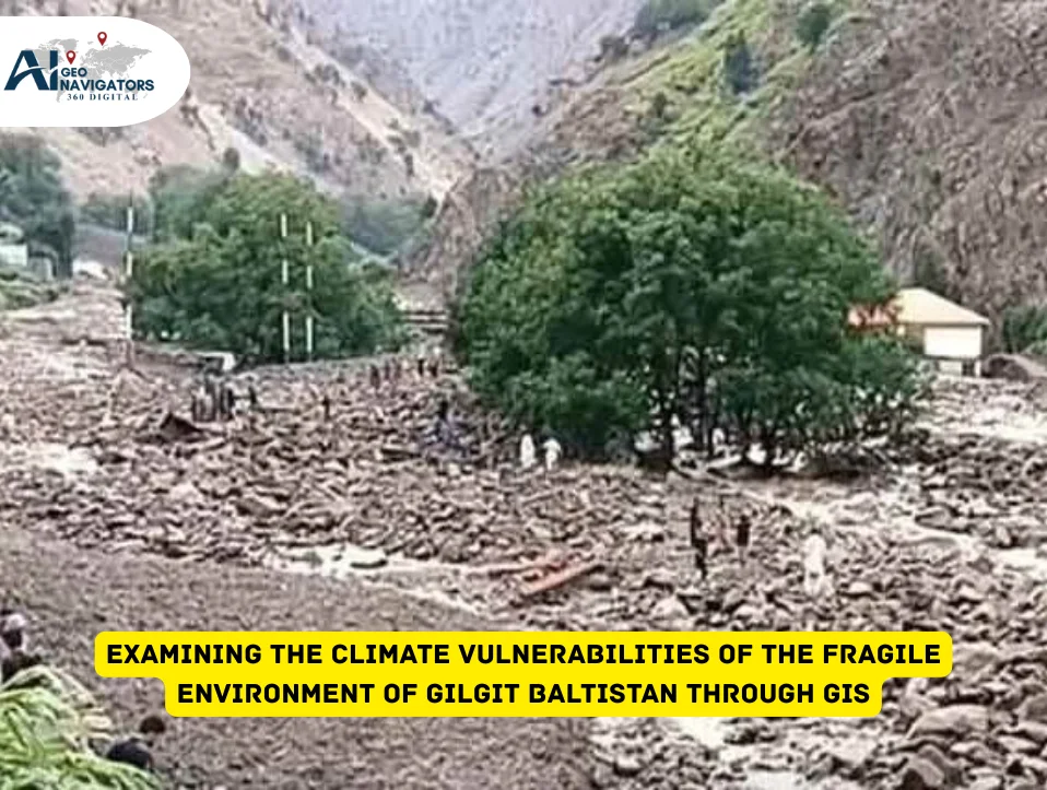
Climate change is turning out to be one of the most significant problems of the 21st century. Climate change has threatened mountainous areas like Gilgit Baltistan, especially because they have fragile ecosystems.
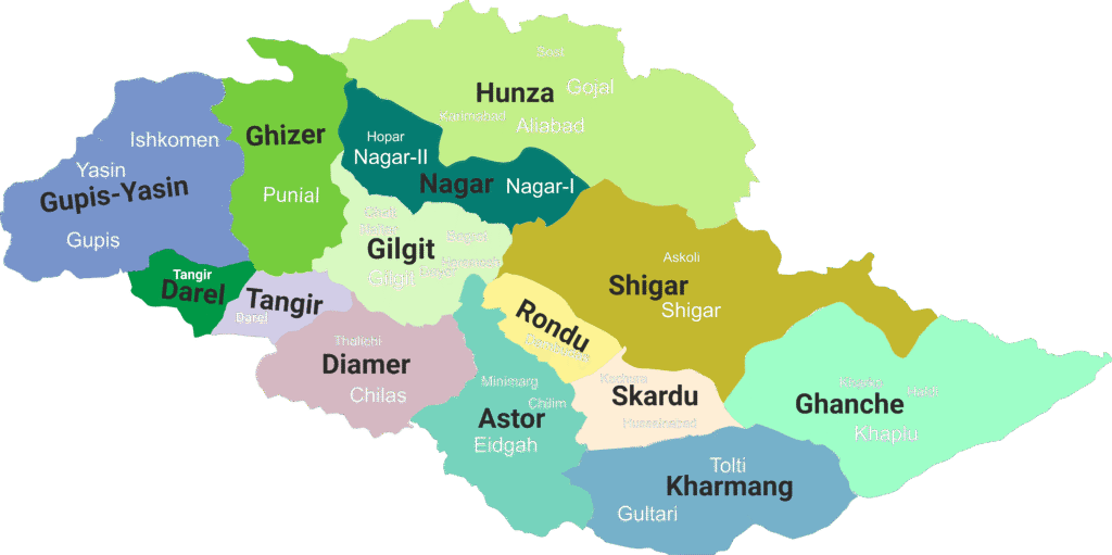
An ecologically sensitive and high-altitude region of the northern region of Pakistan, Gilgit-Baltistan. It is situated between the Karakorum and Pamir and the Greater Himalaya and the Hindukush Mountain ranges, which are high and steep valleys, glaciers, rivers, dry lands, and scattered human settlements.
The area is home to K-2 Nanga Parbat and Rakaposhi, the three highest globally. The very geography that brings about beauty and unusual nature to the region also makes the region extremely vulnerable to the growing effects of climate change. Climate change has a significant adverse impact on the Highland environment, where its ecological effects are more pronounced.
Temperature rise, glaciers melting, flash flooding, alterations in climatic patterns, and unreliable slopes are becoming more threatening to the populations and environmental systems. Global warming is taking some expected outcomes. Geographic Information Systems (GIS) have thus become a key to comprehending, mapping, and assessing climate vulnerability in Gilgit-Baltistan.
Source: Khan, A. N., Iqbal, S., Asif, M., & Basit, A. (2019). Floral Diversity of Yasin Valley, Gilgit-Baltistan, Pakistan.
Role of Geographic Information System (GIS)
GIS enables researchers and planners to examine land, people, and climate as a single system instead of individual parts. With spatial data, satellite imagery, and digital maps, GIS can highlight more vulnerable areas in Gilgit-Baltistan to hazards like landslides, glacier lake outburst floods, river flooding, drought, heat stress, or land degradation.
In an area where most settlements have been constructed along steep banks and along riverbeds, the form of mapped knowledge is extremely important. Lacking information about more vulnerable communities, one cannot make policies, act to prevent, or plan safer development in the future. GIS helps identify and monitor these trends over time by comparing old and new satellite images.
Climate Risks
GB is a very fragile ecosystem in terms of climate change. Climate risks in the region are also being affected by urbanization and land-use change. When open land, agricultural lands, and natural slopes are converted into built-up areas, the water absorption rate decreases, and floodwater becomes more likely to flow at a faster rate across the land surface.
Worldwide, the urbanization process is evolving at the expense of green spaces, resulting in a dense concrete jungle with severe and harmful effects on the ecosystem. Mountainous regions, such as Gilgit Baltistan, are particularly vulnerable to these changes due to their fragile ecosystems, limited space for expansion, and high exposure to climate-related hazards.
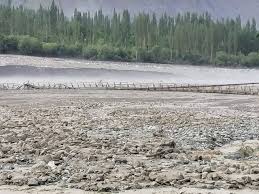
Recently, the flood destruction in the Dain and Raushan valleys of Gilgit is a visible example of unsound landscapes being altered without adequate planning. The unguarded valleys of GB, like Hunza, Astore, Ghizer, and Diamer, vary in terms of elevation, water resources, land cover, vegetation, and human activities. Most construction also increases pressure on land stability. GIS can monitor the growth of cities and their interactions with the current vulnerable landforms.
This connection is important because even small mistakes in construction or land clearing in mountain regions can later turn into disasters when it rains heavily or the snow melts. GIS-based climate vulnerability assessment does not just examine physical hazards. It also takes into consideration the exposure and sensitivity of communities. Some villages are located along riverbanks.
“Near the riverbanks, there is a development, and the water flow gets disturbed, and when you block the water flow, it diverts towards your living space and society.” (Climate Activist)
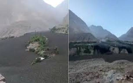
Raushan and Dain Valleys of Gilgit
Integration of Artificial Intelligence (AI)
Artificial intelligence has also begun to assist GIS analysis in recent years by identifying patterns that humans may overlook. High-resolution models can monitor how the glacier cover, the movement of rivers, and the temperature change on the surface of the land, at extremely small scales. These AI-based objects assist in predicting potential future states, as opposed to merely displaying what has taken place in the past.
For regions like Gilgit-Baltistan, where the climatic processes are occurring at a faster rate than in many other parts of the world, such predictive insight is valuable for planning adaptation strategies on time. GIS applicability in vulnerability assessment is not limited to research papers. It directly involves itself with planning and safety. Government departments, disaster management authorities, development organizations, and even private companies can utilize the GIS-based vulnerability assessment to make responsible decisions.
Community Awareness through GIS
Climate vulnerability using GIS in Gilgit-Baltistan also contributes to the enhancement of community awareness. Sometimes, the local people do not believe that climate risks are increasing until they see visual evidence. The company’s strategy is shaped by the belief that climate resilience in mountain environments must be informed by data rather than intuition.
The process of sharing GIS outcomes in the form of simple maps allows even non-technical audiences to comprehend the areas that are not safe and why. Such awareness may lead to more intelligent community practices, such as avoiding construction in flood-vulnerable areas, planting more trees on slopes, or demanding that authorities provide safer development plans.
Climate change is not something that occurs in the future. Nevertheless, its impact is already felt in the region with more frequent floods, drying pastures, less snowfall in some areas, greater glacier breakages, and erratic weather patterns.
Advantages of GIS
One of the biggest advantages of GIS-based vulnerability assessment is that it can be updated over time. The patterns of climate are not fixed, and the area is experiencing environmental changes. With time, it is possible to monitor the evolving levels of risks by updating satellite images, digital elevation maps, temperature measurements, and land-use maps regularly. This has made climate action dynamic and not static. Decision-makers will be able to react to the current evidence that has been updated rather than acting upon previous assumptions.
Conclusively, climate vulnerability assessment of mountainous regions of Gilgit-Baltistan with the help of GIS is becoming an emerging key technique of climate-resilient planning. The vulnerable ecology of the region, the expanding settlements, the reliance on the glaciers, and the terrain, which is risky, necessitate resolutions founded on valid and recent information.
GIS integrates land information and climatic information with human information in a single system that can easily indicate where the danger is rising and where it is most required. In a world that continues to require sustainability and aversion of the impact of climate change, GIS application enhances not just the security of the local people but also global responsibility. Through the integration of current mapping and climate consciousness, it is possible to safeguard individuals, conserve the biosphere, and secure growth in a manner that increases resiliency.


