The world has been experiencing heat waves for the last few decades. Climate change has increased both the frequency, intensity, and duration of heat waves in recent years. This is not just about a hot summer; it now poses escalating threats to our health, food supply, energy systems, and urban infrastructure.
Cities suffer from this problem much more due to the urban heat island effect—that is, after buildings roads, and concrete surfaces absorb and trap a lot of heat making urban areas much warmer than the surrounding rural areas.
The problem boils down to the increased accumulation of greenhouse gases in the atmosphere. While these gases raise the earth’s temperature, they also interfere with the natural circulation of air; hence, consistent and extreme fluctuations in temperature occur, which are getting harder to control.
In tackling this growing challenge, proactive, smart, data-driven solutions are needed that enable us to act before damage is done. Traditional approaches cannot suffice anymore. Geographic Information Systems, or GIS for short, emerge as a game-changer in this regard.
GIS allows researchers, governments, and urban planners to combine satellite images with real-time data and geospatial information to determine where heat waves are hitting hardest which communities are most vulnerable and how to intervene effectively and on time.
GIS enables us to forecast heat patterns, develop early warning systems, and make climate-resilient urban plans-adding green space, improving ventilation in the urban structure, or establishing designated heat safety zones. GIS thus cannot be a mere mapping tool; it has turned into a vital resource for effective, efficient, and smart responses against climate change.
What Are Heat Waves?
A heat wave is not simply a hot day, it is a prolonged occurrence of excessive heat, lasting several days or even weeks, and it has been observed that with climate change its frequency, intensity, and duration are increasing at an alarming rate. This is not the summer heat we take as normal; this constitutes a significant rise in temperature that becomes life-threatening especially to susceptible populations like children, old-aged persons, and those who work outdoors. Such rigorous climatic conditions exert tremendous stress on the human body and raise the likelihood of experiencing heat exhaustion, dehydration, or even death.
Heat waves seriously threaten day-to-day living, they affect agricultural produce and reduce the productivity of animals, etc. In addition, they overheat electricity systems due to increased demand for air conditioning, leading to blackouts in many cases. The combined effect on public health, food security, and infrastructure makes heat waves one of the deadliest—and often least understood—natural hazards.
The harsh reality is that our traditional coping mechanisms are no longer enough. As heat waves grow more unpredictable and intense, we must shift from reactive to proactive strategies. This includes deploying smart, data-driven solutions such as real-time monitoring, early warning systems, and climate-resilient urban planning.
Cities need to be redesigned with heat in mind—by increasing green spaces, improving ventilation, and developing policies that prioritize public safety during extreme weather. In the age of climate change, preparing for heat waves isn’t optional, it’s essential for protecting lives, sustaining food systems, and ensuring urban resilience.
Understanding Heat Waves and Their Human Impact
Heat waves are not just about how hot; however, they are dangerously the longest heat of extreme heat that can push our bodies and communities to their limits. Climate change makes them more frequent, longer and harsh, these events are becoming a serious health crisis, not just a seasonal discomfort. So, what causes them, and why are they getting worse? The main culprit is the high-pressure systems in the atmosphere that trapped the heat near the surface of the earth, which can uncheck the temperature. Add to that the rising global temperatures due to greenhouse gas emissions, and we are paying attention to the future with more intense heat. (Urban Heat Island) Effect – concrete, buildings and roads absorb heat all day and release it slowly at night, turning urban areas into virtual ovens, with hardly any natural cooling from trees or green spaces.
When a heat wave hits, it simply does not affect the weather – it is also our bodies. Our natural cooling system is kicked by sweating, but it also drains the body of our water and salts that are important to act properly for our muscles and nerves. That is why people are dizzy, tired or dizzy during extreme heat. For people with heart problems, it can be more dangerous – heat brings extra pressure to the heart and can lead to serious conditions such as stroke or heart attack. Beyond the physical toll, the heat of the heat also gives the clouds to our thinking. It is difficult to focus, people feel irritable or confused, and simple tasks become boring.
Heat-Related Illnesses and Conditions
| Condition | overview |
| Heat Cramps | Painful muscle cramps due to loss of salts through heavy sweating |
| Heat Exhaustion | Symptoms include headache, nausea, dizziness, weakness, and heavy sweating |
| Heat Stroke | Medical emergency with body temperature > 40°C (104°F); can cause coma or death |
| Dehydration | Causes fatigue, confusion, dry mouth, and reduced urination |
| Heat Exhaustion (non-fever) | High body temperature not caused by infection |
| Sunburn | Skin damage due to UV exposure; increases skin cancer risk |
| Cardiac Stress | Elevated heart rate and blood pressure can trigger heart attacks or strokes |
| Kidney Issues | Dehydration can lead to kidney stones or acute kidney failure |
| Respiratory Stress | High temperatures and pollution worsen breathing issues like asthma |
Some people are particularly vulnerable during heat waves: older people and babies have less effective temperature regulation and are more likely to become heat stressed. When working in the sun all day, outdoor workers such as farmers and construction labourers can work with dehydration and other heat-related issues.
The heat can exacerbate conditions of people with chronic illnesses, like asthma, heart disease or kidney conditions. Low-income communities are particularly vulnerable: They lack ample access to not only air conditioning but also health care or safe housing, leaving them more exposed to the hazards of extreme heat. That’s why tailored support and community-level action are so important to protect those most at risk.
Although several measures can be taken to safeguard ourselves and others against heat waves, hydration is crucial in this aspect. It involves the consumption of adequate amounts of water and the avoidance of beverages like coffee and alcohol that aggravate dehydration. Not engaging in outdoor activities during the hot hours of the day—usually between 11 AM and 4 PM—dressing in loose-fitting light-colored clothes, and remaining in shaded or air-conditioned locations make a significant difference.
Fans, cool baths, and air-conditioned spaces are indeed lifesavers during these times. During heat waves, communities as well as healthcare systems must remain vigilant and public education efforts will help people identify symptoms early on. Early warning systems may also grant time to prepare thereby minimizing the impact of extreme heat on people.
How GIS Helps Tackle Heat Waves
In location and timing, GIS, Geographical Information System is proving to be an extremely effective tool for monitoring heatwaves in real-time with remarkable precision. Typically, satellite data from Landsat or the Moderate Resolution Imaging Spectroradiometer enables us to determine the surface temperature of the land over vast regions without being on the ground.
However, it doesn’t stop there. This satellite data combined with information from ground-based meteorological stations makes it possible to map temperature variations in urban areas, cities, and countryside much more comprehensively and accurately.
Mapping of urban heat islands (UHIs) where cities are much hotter than adjacent rural areas due to a lack of green, roads, and a dense structure is indeed a very significant application of GIS.
By using tools such as NDVI (generalized difference botanical index), where small plant areas that absorb heat are identified, remote sensing makes it possible to assess the surface condition. By studying temperature patterns over time, researchers can see how heatwaves develop, identify new hotspots as they break out, and monitor changes. This information is critical not only in providing early warning but also in helping governments and planners prepare for long-term climate challenges.
Role of GIS in Heat Wave Management
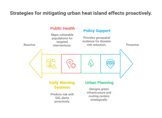
Geographical Information System (GIS) plays an important role in managing heat waves, offering a series of equipment to predict authorities, plan and protect communities. The most important contribution of GIS is in the creation of early warning systems. By analyzing historical temperature records, current land surface data and weather forecasts, GIS can identify areas that are likely to experience excessive heat. This allows timely alert to release through map, dashboard or mobile information, ensuring that both public and emergency services are aware and ready to respond.
GIS is also a powerful property in urban planning and infrastructure design. This helps planners to imagine which neighborhoods are the most affected by high temperatures-often dense construction, minimal tree covers and asphalt surfaces.
These insights inform the plan of the smart city, such as adding more green locations, using heat-threatening materials, and designing the cooler having naturally cooler. Over time, such changes make cities more loadable and flexible against rising temperatures.
In the field of public health, GIS helps to identify who is the weakest during summer waves. By combining demographic and geographical data, it exposes risky groups such as elderly, low -income population and external workers.
This allows for targeted interventions, such as preference to these communities for cooling centers, medical care and emergency support. GIS can also analyze accessibility, ensuring that these population can reach essential services such as hospitals and shelters during emergency conditions.
At the policy level, the GIS supports making better decisions by providing clear, location-based evidence of heatwave effects. This shows exposure to hotspots, population weaknesses and infrastructure, helps governments and planners to develop strategies of disaster risk decrease.
GIS also enables long-term monitoring of the surface temperature of the land and evaluates how much of adaptation measures feel-like planting more trees or using reflective roof. Such data-powered insights ensure that policies remain responsible and effective as climate conditions develop.
Best GIS Tools for Heat Wave Analysis
There are a number of strong GIS technologies available for efficiently assessing and controlling heat waves. Real-time temperature monitoring and trend analysis are made possible by the widespread usage of Google Earth Engine (GEE) for processing and analyzing massive amounts of satellite data, including MODIS and Landsat imagery.
Strong features for creating interactive dashboards, mapping populations at risk, and creating predictive risk models specifically for urban settings are provided by ArcGIS Pro and ArcGIS Online. For individuals looking for open-source alternatives, QGIS offers adaptable options for performing spatial analysis and creating urban heat maps.
For evaluating temperature and surface conditions, when combined these resources provide a whole arsenal for accurately and perceptively addressing the increasing problem of heat waves. MODIS and Landsat data portals are crucial sources of both historical and near-real-time thermal images.
Conclusion
Accurate, data-driven insights about tracking, evaluating, and managing heat wave impacts make GIS stand out as an increasingly smart solution toward building climate resilience. It combines demographic, environmental, and infrastructure data to support decisions of greater quality.
There is additional need for greater integration of GIS into policy formation, urban planning, and community-level adaptation methods to effectively manage the escalating threat of excessive heat. Moreover, a cross-sector collaboration among government agencies, research institutions, NGOs, and local communities is needed to develop proactive sustainable systems that protect vulnerable populations while building long-term climate resilience against heat waves instead of just managing them.