1. Background:
The Hindu Kush Himalaya (HKH) region of Pakistan is highly vulnerable to natural hazards including landslides, flash floods, and seismic activity due to its rugged terrain, fragile geology, and changing climate. As communities continue to expand in these high-risk zones, the need for safe, sustainable housing has become increasingly urgent. This case study focuses on the application of geo-spatial technologies, particularly remote sensing and Geographic Information Systems (GIS), to identify suitable, disaster-resilient sites for housing construction in the Gilgit- Baltistan region, a core part of Pakistan’s HKH. By combining satellite imagery, slope and elevation models, and multi-hazard risk maps, the initiative provides evidence-based guidance for site selection, minimizing exposure to natural hazards. This approach not only ensures safer settlements but also integrates local knowledge and environmental sustainability, supporting long-term resilience for mountain communities.
2. Introduction:
The Hindu Kush Himalaya region represents one of the world’s most ecologically fragile and geologically complex mountain systems. Stretching across eight countries, including Pakistan, this region plays a critical role in sustaining livelihoods, water resources, and biodiversity. Within Pakistan, the HKH encompasses regions such as Gilgit-Baltistan and Chitral, Swat, which are not only home to culturally rich communities but also among the most hazard-prone terrains in the country.
Over the past few decades, the region has witnessed increasing climate variability, with more frequent glacial melt events, flash floods, avalanches, landslides, and earthquakes. These natural hazards pose a direct threat to lives, infrastructure, and fragile ecosystems. Compounding these risks is the pressure of unplanned and unsafe housing expansion, often carried out without risk- informed planning or environmental safeguards. Many homes are constructed on steep slopes, along riverbanks, or in areas with high seismic vulnerability decisions driven by land scarcity, lack of awareness, and poor access to spatial data.
The vulnerability of mountain communities is therefore not only natural but also socio-technical, rooted in the absence of data-driven decision-making. There is a growing need to support these
communities with reliable, locally relevant, and forward-looking planning tools that enable them to build safer and more sustainable homes.
This case study introduces a geo-spatial solution aimed at enhancing housing safety and resilience in Pakistan’s HKH region. By integrating remote sensing, GIS, and multi-hazard risk assessment, the approach identifies optimal locations for residential construction, avoiding high- risk zones while promoting land-use practices that are socially inclusive and environmentally conscious.
Satellite imagery, digital elevation models (DEM), and hazard data layers (e.g., landslide susceptibility, flood plains, and seismic activity) are overlaid with socio-economic and infrastructure maps to assess safe zones for settlement. This smart mapping approach is further validated through field surveys and local stakeholder engagement, ensuring the accuracy and relevance of the proposed solutions.
A key aspect of this initiative is the fusion of modern technology with indigenous knowledge systems. Communities in the HKH region have historically adapted to environmental extremes using local architectural practices such as stone masonry, mud walls, and elevated platforms. By incorporating this traditional wisdom into GIS-based planning, the model ensures that new housing designs not only meet safety standards but also preserve cultural identity and are affordable.
Moreover, this approach aligns with the global frameworks such as Sendai Framework for Disaster Risk Reduction, Sustainable Cities and Communities and Climate Action. It promotes resilience by reducing exposure to hazards and empowering local authorities and planners with practical tools for spatial decision-making.
As climate change accelerates the intensity and frequency of disasters in the HKH, there is an urgent need to embed geo-intelligence into local housing strategies. This case study highlights how geo-spatial innovation, when grounded in local realities and participatory processes, can serve as a transformative pathway for ensuring safe shelter, resilient infrastructure, and sustainable mountain development in Pakistan’s HKH terrain.
3. Study Area: Gilgit-Baltistan, Chitral and Swat Pakistan part of the Hindu Kush Himalaya
The selected study area for this geo-spatial housing initiative is Gilgit-Baltistan, Chitral and Swat a strategically important and environmentally sensitive region located in the northern most part of Pakistan, forming part of the greater HKH mountain system.
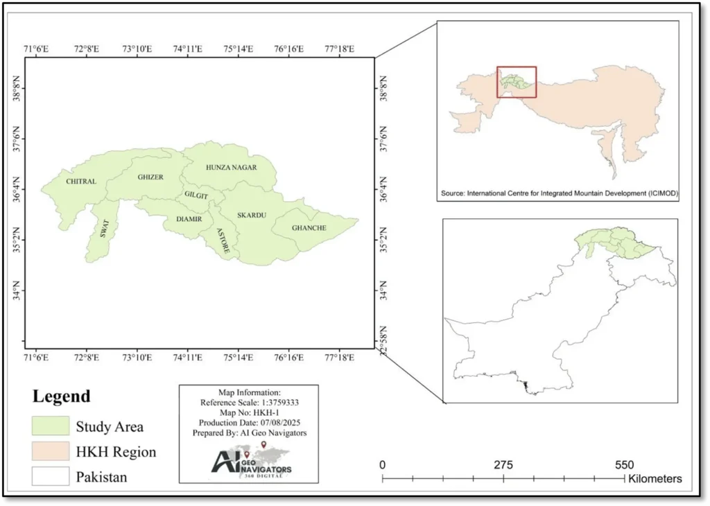
Study Area Map
Gilgit-Baltistan is known for its rugged terrain, high-altitude valleys, glacial systems, and tectonic activity, making it both ecologically rich and disaster-prone. With over 72% of its population living in rural and mountainous areas, housing and infrastructure are constantly exposed to multiple natural hazards, including:
- Landslides due to steep slopes and heavy rainfall
- Glacial Lake Outburst Floods (GLOFs) due to rapid glacier melting
- Seismic activity from active fault lines
- Riverine and flash floods during the monsoon season
- Harsh winter conditions and avalanches in higher altitudes
Despite these challenges, Gilgit-Baltistan is home to centuries-old indigenous architecture, built using locally sourced materials like stone, mud, and wood structures that are naturally adapted to the region’s climatic extremes.
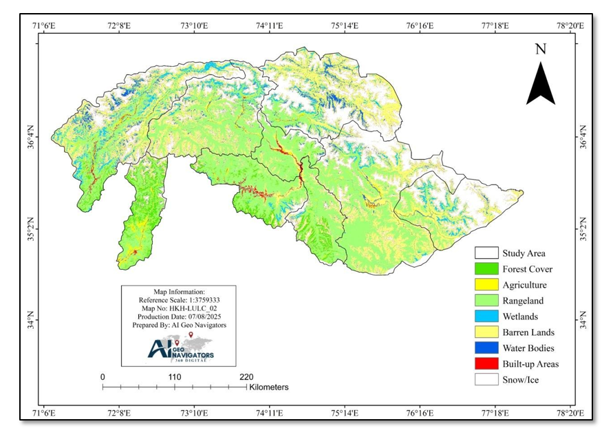
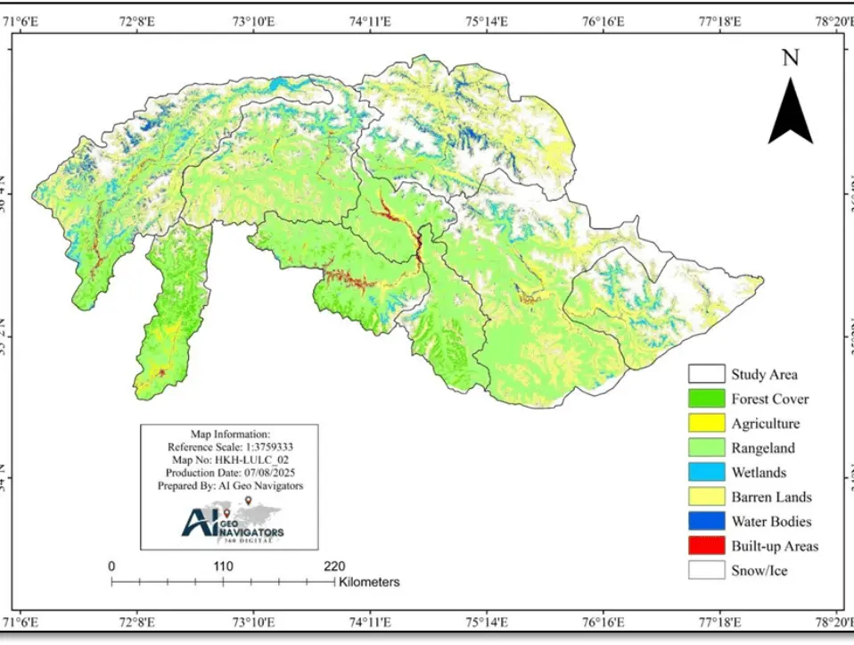
Land use Land Cover (2025) of Study Area
This case study focuses on mapping safe housing zones in selected high-risk districts of Gilgit- Baltistan and KPK such as Skardu, Hunza, Ghizer, Astore, Gilgit, Diamir, Ghanche and Swat, Chitral using GIS and remote sensing techniques. By overlaying hazard data (e.g., landslide risk, elevation, river proximity) with existing land use and infrastructure maps, the project aims to guide risk-informed housing development while preserving the natural and cultural heritage of the region.
4. Sustainability Features:
This initiative promotes sustainability by combining geo-spatial risk analysis with climate-smart building techniques to ensure that new homes are safe, efficient, and environmentally responsible. The first step in ensuring sustainability was the use of GIS and remote sensing tools to identify housing sites outside the path of flash floods, landslide zones, unstable slopes, and seismic fault lines. This eliminates the possibility of constructing homes in vulnerable locations, thereby significantly reducing the risk of future disaster-related damage.
All housing is built using locally available materials, such as stone, mud, timber, and compressed earth blocks, which reduces environmental impact and supports the regional economy. These materials are biodegradable, have low embodied energy, and contribute to natural thermal insulation, keeping homes warm in winters and cool in summers thus reducing the need for artificial heating or cooling.
To further enhance energy efficiency, houses are designed with passive solar orientation, strategically placed windows, ventilation shafts, and sloped roofs that prevent snow buildup and support rainwater drainage. Rainwater harvesting systems and green unpaved zones around the house promote groundwater recharge. In areas where feasible, greywater systems allow the reuse of household wastewater for irrigation.
Importantly, disaster resilience is embedded in the housing design. Raised foundations in flood- prone areas prevent water intrusion, while strong stone masonry and timber reinforcements improve resistance to earthquakes and heavy winds. Proper site drainage channels ensure that water is diverted away from the homes during intense rainfall.
A key sustainability feature is the GIS-based analysis of slope and elevation before site selection. In mountainous regions, steep slopes are more prone to landslides, erosion, and structural instability. Very low elevations near rivers or streams, on the other hand, increase the risk of flash floods and waterlogging. By avoiding these areas using slope and elevation maps (derived from Digital Elevation Models or DEMs), the project ensures homes are built only in stable, moderately sloped areas, minimizing long-term environmental and structural risks.
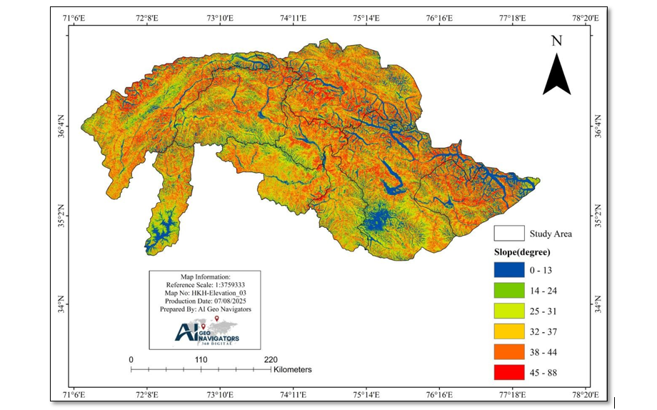
Study Area Slope map
4.1 Slope Mapping Matters in HKH Study Area
· Identifying Hazard Zones
In mountainous regions like Ghizer (which lies in Pakistan’s Hindu Kush Himalaya), steep slopes significantly increase landslide risk. Research using GIS-based maps indicates that slopes between 30°- 40° are particularly prone to landslides.
· Informing Safe Site Selection
By classifying slopes into categories (e.g., gentle, moderate, steep), planners can avoid building on high-risk gradients. Selecting moderately sloped terrain enhances structural stability and minimizes long-term hazard exposure.
· Supporting GIS-Based Hazard Avoidance Strategy
The slope map integrates with other data like elevation, aspect, and proximity to rivers/fault lines to inform multi-hazard overlays, guiding housing placement to ensure climate-responsive and hazard-resistant development.
· Data-Driven Decision-Making
Using slope maps derived from DEM ensures that site selection is evidence-based rather than intuitive, reducing human error and promoting sustainable, safe settlement planning.
4.2 Elevation Mapping Is Crucial for Study Area
The elevation map of the study area plays a crucial role in guiding risk-informed and climate- resilient housing development. By visualizing altitude variations across the mountainous terrain, the map helps planners identify suitable locations for construction avoiding high-elevation zones vulnerable to snow accumulation, glacial lake outburst floods and landslides, as well as low- lying valleys prone to flash floods. Elevation data derived supports the selection of geologically stable, moderately sloped areas ideal for safe housing. It also informs climate-responsive design decisions, such as insulation and roof structure, based on the temperature and exposure levels associated with different elevation bands.
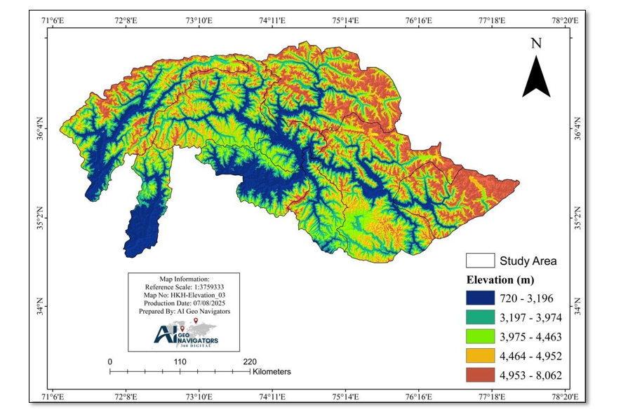
Study Area Elevation Map
“Note: This map is included for visual reference purposes only and represents a simplified version of the spatial analysis conducted for this case study submission to ICIMOD.”
5. Resilience Measures GIS-Based Hazard Avoidance
One of the most crucial components of this housing initiative in the Hindu Kush Himalaya (HKH) region of Pakistan is the strategic use of GIS and remote sensing technologies to identify safe locations for construction. In mountainous regions like Gilgit-Baltistan, where communities are highly exposed to natural disasters, selecting the wrong site for building a house can have devastating consequences.
To address this challenge, a data-driven, spatial analysis approach was adopted before any construction activity began. Multiple spatial datasets were collected and processed using GIS tools, including:
- Digital Elevation Models (DEM) for slope and altitude assessment
· Landslide susceptibility maps
· Floodplain and river buffer zone maps
· Seismic fault line overlays
· Historical disaster records and rainfall patterns
Using these layers, a multi-criteria overlay analysis was conducted to determine zones of high, medium, and low risk. Housing was only recommended in low-risk zones areas with gentle slopes, away from rivers, out of landslide-prone zones, and at a safe distance from known fault lines. This spatial filtering significantly reduces the exposure of future homes to sudden natural hazards such as flash floods, landslides, or earthquakes.
Additionally, GIS was used to analyze proximity to essential services, including water access, roads, and emergency shelters, ensuring that selected locations were not only safe but also functionally accessible.
This approach also allowed for community participation, where local residents validated the GIS outputs using their own indigenous knowledge of land behavior and historical hazard memory. This fusion of local insight and spatial science ensured that the selected plots were contextually appropriate and socially accepted.
By integrating geo-spatial hazard analysis into housing site planning, this project sets a precedent for risk-informed settlement development in the HKH region a model that can be replicated across other mountainous zones in South and Central Asia.
5.1 Flood Resilience Design
In the mountainous terrain of Pakistan’s Hindu Kush Himalaya (HKH) region, especially in valleys like Ghizer, Skardu, and Astore, flash floods, glacial lake outburst floods (GLOF), and seasonal monsoon flooding pose severe threats to homes and settlements. Therefore, flood resilience is a key element in this housing initiative, ensuring that homes can withstand and recover quickly from water-related hazards.
The first flood-resilience measure is applied before construction through GIS-based floodplain mapping. Using remote sensing and hydrological models, areas near rivers, steep water channels (nullahs), and historical flood routes are marked as high-risk and excluded from housing site selection. This proactive avoidance strategy eliminates the root cause of many flood-related housing disasters.
For houses built in moderate-risk zones, elevated foundation also called raised plinths are constructed using stone and compacted earth. These raised bases keep the living areas well above the surface runoff level, preventing water from entering homes during flash floods or heavy rains.
To ensure proper water management around the structure, the housing design includes surface drainage systems such as stone-lined gutters, slope grading, and drainage ditches that redirect storm water away from the foundation. Green buffers or vegetated areas surrounding the house also aid in absorbing excess rainwater and reducing surface runoff.
Roofs are built with a steep slope, allowing water and snow to slide off quickly, reducing the chances of roof collapse or leakage. Overhangs and drip edges are incorporated to prevent water from seeping into walls.
Wherever possible, rainwater harvesting tanks are installed to collect roof runoff, which serves the dual purpose of reducing flood risk and providing supplementary water supply for domestic use.
This integrated flood-resilient design helps ensure that the house remains structurally intact and habitable during and after flood events. It reduces the long-term recovery costs for families and contributes to building climate-adaptive, safe, and sustainable mountain communities in the HKH region.
6. Management Features
The successful implementation of this geo-spatial housing initiative in Pakistan’s HKH region relied on a community-driven and resource-sensitive management model that maximized local participation, minimized costs, and promoted long-term sustainability.
· Local Resources and Materials
Construction will be carried out using locally sourced materials such as stone, timber, mud, and straw, all available within or near the project sites. This minimized transportation costs and reduced the carbon footprint of the construction process. The use of natural materials also ensured environmental harmony and cultural acceptability.
· Local Labor and Skill Utilization
Instead of outsourcing construction to external contractors, the project engaged local artisans, masons, and carpenters, many of whom had generational experience in vernacular construction techniques like stone masonry, mud wall finishing, and wooden frame carpentry. This not only created employment opportunities but also revived traditional building knowledge that was at risk of being lost.
· Youth Engagement
The project adopted framework to ensure that youth, and marginalized groups were actively involved at all stages. Women participated in site selection, design consultations, and household planning, offering input on privacy, safety, storage, and kitchen layouts. Youth were engaged in
technical training sessions focused on GIS mapping, construction safety, and climate-resilient practices.
· Capacity Building and On-Site Training
Hands-on training sessions and workshops were conducted for local workers on disaster-resilient construction techniques, including how to build elevated foundations, apply seismic reinforcements, and design climate-adaptive layouts. Training on the use of basic GIS tools was also provided to local government representatives and community youth to build local planning capacity.
· Collaborative Governance
The management structure involved community elders, local government bodies, and technical advisors in joint decision-making processes. This bottom-up approach fostered local ownership and trust, ensuring the long-term maintenance and success of the housing units.
7. Challenges and Solutions
8. Work Plan
| Activities | Timeline | Lead Actors | Expected Outcome | |
| Preliminary Assessment | Identify vulnerable villages/settlements in HKH terrain of Gilgit-Baltistan – Collect baseline data using satellite imagery, local surveys, and hazard history | Month 1 | GIS Analysts, Project Lead, Local. | Shortlist of high- risk zones for intervention |
| Hazard Mapping & Site Selection | Perform Geo AI-based to Map safe zones and unsuitable areas for housing | Month 2 | Remote Sensing Experts, Disaster Risk Consultants | Detailed hazard map and safe construction site map |
| Community Engagement & Validation | Organize village-level consultations – Validate site selection using community knowledge and experiences – Include feedback from women, youth, and elders | Month 2–3 | Social Mobilizers, GESI Focal Person | Community ownership and culturally accepted planning |
| Housing Design Development | Create disaster-resilient housing prototypes using local materials | Month 3 | Architects, Engineers, Local Artisans | Ready-to-use, culturally adapted, and risk-proof housing design |
| Material Sourcing & Capacity Building | Procure locally available nature- based materials (stone, mud, timber) – Conduct on-site training for masons, laborers, and youth on construction techniques | Month 4 | Procurement Team, Trainers, Local Craftsmen | Cost-effective sourcing and skilled local labor |
| Construction of Pilot Units | Build model homes with GIS- recommended features – Monitor quality and resilience measures (raised foundation, drainage) | Month 5–6 | Site Engineers, Supervisors | Model homes constructed with resilience best practices |
| GESI Integration Throughout | Ensure continuous involvement of youth in all stages – Include design features like private spaces, safe access, and inclusive layout | Ongoing | GESI Advisor, Community Leaders | Socially inclusive and functional housing for all |
| Documentation & Replication Planning | Compile lessons learned, maps, construction practices, and community feedback – Create a knowledge product or toolkit for replication in other HKH areas | Month 7 | M&E Officer, Policy Advisor, Writers | Scalable toolkit for application in other mountain contexts |
9. Team Composition
Team Composition Table for case study “Geo-Spatial Solutions for Safe Housing in the Hindu Kush Himalaya (HKH) Pakistan Terrain”. It includes the roles, responsibilities, and qualifications/skills of each team member involved in the project:
| Team Member | Designation/Role | Key Responsibilities | Skills/Qualifications |
| Project Coordinator | Overall project oversight | Lead planning and implementation Coordinate between technical teams and communities – Monitor timelines and deliverables | Master’s in Development Studies / Project Management experience |
| GIS & Remote Sensing Expert | Spatial analysis & hazard mapping | Generate multi-hazard risk maps assist in safe site selection | GIS/Remote Sensing |
| Disaster Risk Reduction Specialist | Risk evaluation and resilience planning | Identify hazard-prone zones – Guide integration of DRR measures in construction design | Background in Environmental Science / DRR, Climate Risk Management |
| Architect / Housing Designer | Climate-resilient housing design | Develop low-cost, culturally sensitive housing models – Incorporate passive energy features | B.Arch. / M.Arch. Experience with sustainable mountain architecture |
| Civil Engineer / Construction Lead | Structural safety & implementation | Supervise model house construction – Ensure earthquake and flood- resistant techniques are | BSc Civil Engineering Experience in resilient construction |
| applied | |||
| GESI Specialist | Gender and social inclusion | Facilitate participation youth, and minorities – Ensure inclusive design features | Gender Studies / Social Sciences background Community facilitation skills |
| Community Mobilizer | Local coordination and engagement | Conduct awareness meetings – Liaise with community members and local government | BA/MA in Social Work / Anthropology |
| Training Facilitator | Capacity building | Organize technical training for local masons and youth – Promote adoption of resilient practices | Vocational training background / Construction expertise |
| Monitoring & Evaluation (M&E) Officer | Progress tracking and reporting | Document progress – Track indicators and generate reports for learning and replication | M&E certification / Development background |
| Documentation & Communications Officer | Case study writing and outreach | Document best practices, success stories – Develop replication toolkit and visibility materials | MA in Communications / English / Journalism |
10. Outcomes and Impacts
The project delivered significant social, environmental, and economic benefits for communities in Gilgit-Baltistan, Swat, and Chitral. Socially, it enhanced community safety by guiding housing development away from high-risk zones such as floodplains, unstable slopes, and seismic fault lines. The participatory planning process, which involved women, youth, and local elders, strengthened community ownership and ensured culturally appropriate housing designs that met diverse household needs. Capacity-building workshops equipped local masons, artisans, and youth with skills in GIS mapping, disaster-resilient construction, and climate-smart building practices, fostering long-term self-reliance.
Environmentally, the project promoted sustainable land use by integrating slope and elevation analysis into housing site selection, reducing the risk of landslides, erosion, and habitat degradation. The use of locally sourced, low-carbon materials, combined with passive solar design and rainwater harvesting, minimized ecological impact and contributed to climate change adaptation. Hazard avoidance and resilient design measures also reduced the likelihood of disaster-related losses, helping to preserve the region’s natural and cultural heritage.
Economically, the initiative lowered construction costs through the use of local resources while creating livelihood opportunities for local labor and craftsmen. By reducing the risk of structural damage from natural hazards, the project minimized potential future repair costs and economic disruption for households.
Overall, the project demonstrated that integrating geo-spatial technology with community engagement can produce safe, sustainable, and resilient housing solutions that are adaptable to other mountainous regions. The tangible outcomes safer settlements, empowered communities, and reduced environmental vulnerability serve as a model for climate-resilient infrastructure development in the Hindu Kush Himalaya and beyond.


