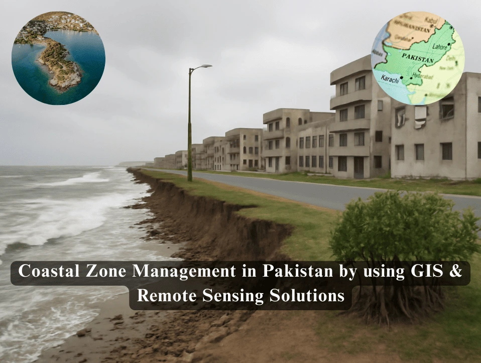
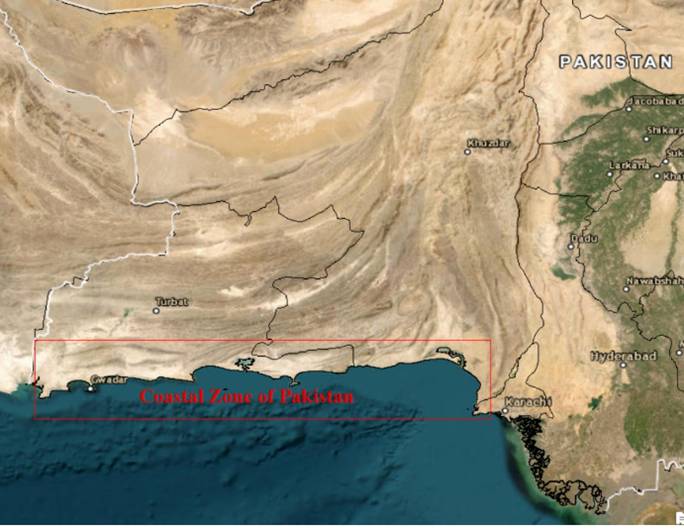
Pakistan’s coastline, stretching from the Arabian Sea to the Makran Coast, including key coastal cities like Karachi, is home to critical marine ecosystems and supports essential industries such as fishing, shipping, and tourism. The coastline also includes important regions like the Indus Delta, Gwadar, and the Makran Coast. These areas are vital for biodiversity, providing habitats for a range of species, while also supporting local communities and industries.
However, these coastal zones face increasing environmental challenges due to human activities, such as overfishing, pollution, urbanization, and natural phenomena like rising sea levels and storms. Coastal zone management is therefore vital to protecting these ecosystems and ensuring the sustainable use of coastal resources.
In this context, Geographic Information Systems (GIS) and Remote Sensing (RS) offer powerful tools for monitoring and managing coastal environments. This article explores how GIS and Remote Sensing can address issues such as coastal erosion, marine pollution, and habitat protection along Pakistan’s entire coastline.
Coastal Erosion a Growing Challenge
Coastal erosion along Pakistan’s coastline, particularly in the Makran Coast (Balochistan) and parts of Sindh has emerged as a significant environmental concern. This issue is exacerbated by both natural factors and human activities that accelerate the rate of erosion.
One of the primary natural causes of coastal erosion is the rising sea levels caused by climate change. As global temperatures increase, the melting of glaciers and polar ice caps has led to a gradual rise in sea levels. This increase in water level causes seawater to encroach upon the land, leading to the erosion of beaches, cliffs, and coastal dunes. In regions like Balochistan, the Makran Coast is highly vulnerable to this phenomenon, with many areas facing significant land loss due to higher tidal surges and flooding.
The impact of rising sea levels is compounded by the intensity and frequency of storms. Coastal areas in Pakistan are increasingly facing severe weather events, including cyclones and heavy rainfall, which further erode the coastline by increasing wave action and storm surges. This makes the coastline more prone to flooding, destabilizing the land and reducing the availability of fertile land for agriculture and settlements.
- Human activities are equally contributing to the acceleration of coastal erosion. Unregulated construction along the shoreline is one of the most significant drivers of erosion in coastal cities like Karachi and parts of Sindh. Buildings, roads, and other infrastructure block natural sediment flow and disrupt the coastal ecosystem, exacerbating erosion. Poorly planned urbanization has led to the destruction of protective features such as dunes and mangrove forests, which naturally shield the coastline from wave action and tidal surges.
- Another human factor contributing to coastal erosion is sand mining, which removes essential sediment from the coastline, depriving the area of the natural materials required to build up and maintain beaches and dunes. The removal of sand weakens the coastal defenses, making the areas more vulnerable to erosion.
- Additionally, the diversion of rivers, such as the Indus, has reduced the flow of sediment to the coast. The river, which historically brought large amounts of sediment to the delta, is now constrained by dams and water diversion projects. As a result, the Indus Delta, which provides critical protection for coastal communities, is eroding at a rapid pace. The lack of sediment replenishment accelerates the retreat of the coastline, further exacerbating the erosion problem.
- The combined effect of rising sea levels, intense storms, and human interference through construction, sand mining, and the diversion of rivers has led to a dramatic increase in coastal erosion along Pakistan’s coastlines. Areas like the Makran Coast and parts of Sindh are facing critical challenges in preserving their land and ensuring the safety of coastal communities. Addressing these issues requires comprehensive measures, including sustainable urban planning, effective management of natural resources, and efforts to restore and protect vital ecosystems like mangrove forests and dunes.
GIS & Remote Sensing Solutions in Coastal Erosion
GIS and Remote Sensing solutions play a crucial role in monitoring and managing coastal erosion by providing accurate spatial data and real-time observations. GIS helps map and analyze coastline changes, identifying areas most affected by erosion. Remote sensing technologies, such as satellite imagery, enable the assessment of shoreline shifts and vegetation loss.
These tools aid in understanding the impact of rising sea levels, storms, and human activities on coastal regions. Furthermore, GIS and Remote Sensing support decision-making for coastal protection, restoration, and sustainable management strategies.
Satellite Imagery use in Coastal Erosion
High-resolution satellite imagery from sources like Landsat and Sentinel-2 plays a pivotal role in monitoring coastal erosion. GIS utilizes this imagery to track shoreline retreat and land loss over time by analyzing detailed, up-to-date images.
Time-series analysis of satellite data helps assess coastline changes over several decades, providing insights into long-term erosion patterns. This approach enables the identification of vulnerable areas and supports the development of targeted coastal management strategies. Satellite imagery thus offers a cost-effective and reliable method for continuous monitoring of coastal dynamics.
Interferometric Synthetic Aperture Radar (InSAR) Technology use in Coastal Erosion
InSAR technology is essential for monitoring ground displacement, particularly in coastal areas affected by subsidence and erosion. InSAR uses radar signals from satellites to measure changes in the Earth’s surface over time, allowing for high-precision detection of vertical and horizontal movements. By analyzing the phase differences between radar images taken at different times, InSAR can pinpoint even small shifts in the ground, which are crucial for understanding coastal subsidence.
This technology is particularly useful for detecting ground deformation caused by rising sea levels, as well as seismic activity and land subsidence. InSAR data provides valuable insights into how coastal regions are responding to climate change and helps in identifying areas most at risk of erosion or flooding. The continuous monitoring capability of InSAR makes it a powerful tool for long-term coastal management and disaster preparedness. Additionally, InSAR is non-invasive and can cover large areas, making it a cost-effective alternative to traditional ground-based measurements.
Marine Pollution Tracking & Reducing Its Impact by GIS & Remote Sensing in Pakistan
Pakistan’s coastal regions, particularly Karachi and Gwadar, suffer from significant marine pollution. Industrial waste, oil spills, plastic debris, and untreated sewage contribute to deteriorating water quality and marine life health. This pollution not only affects biodiversity but also threatens livelihoods dependent on fishing and tourism.
GIS & Remote Sensing Solutions in Marine Pollution Tracking
Pollution Detection via Satellite Imagery by Remote sensing technologies, particularly MODIS and Sentinel-1, can monitor water quality and identify pollution hotspots along the coastline. These satellites can detect changes in chlorophyll-a concentration and turbidity, which are indicators of pollution.
Oil Spill Detection by using GIS & Remote Sensing
Synthetic Aperture Radar (SAR) technology is particularly useful in detecting oil spills and tracking their movement. Sentinel-1 and Radar sat missions can provide real-time monitoring of marine pollution, especially during storm events or when industrial accidents occur.
Water Quality Monitoring by using GIS & Remote Sensing
Remote sensing tools can help assess the spatial distribution of pollutants in the water, allowing for the monitoring of pollutants such as nitrates, phosphates, and heavy metals. GIS-based decision support systems can integrate this data with demographic and economic information, aiding in the identification of high-risk areas and more effective policy formulation.
Habitat Protection by using GIS & Remote Sensing
Habitat protection is a crucial aspect of conservation efforts, and GIS and Remote Sensing is powerful tools for monitoring and safeguarding natural habitats. These technologies help in identifying, mapping, and analyzing ecosystems, providing valuable insights into habitat distribution, quality, and potential threats.
Remote Sensing uses satellite and aerial imagery to gather information about large, often inaccessible areas. This imagery can include multispectral, hyperspectral, and radar data, which reveal the physical and biological properties of various habitats. By analyzing this data, environmentalists can identify different types of vegetation, water bodies, land use patterns, and terrain characteristics that are essential for habitat monitoring. For example, vegetation indices such as the NDVI (Normalized Difference Vegetation Index) are commonly used to assess the health and density of vegetation in a habitat, helping to detect areas at risk of degradation.
One of the key benefits of GIS and Remote Sensing in habitat protection is their ability to monitor changes over time. By using time-series analysis of satellite imagery, environmentalists can track habitat changes such as deforestation, wetland drainage, or coral reef bleaching. This is particularly important in areas where rapid environmental changes are occurring, such as tropical forests or coastal ecosystems. The continuous monitoring provided by satellite data ensures that any significant changes can be detected early, enabling proactive conservation measures.
Habitat restoration by using GIS & Remote Sensing
Habitat restoration efforts can also be enhanced using these technologies. By mapping degraded areas and analyzing the factors contributing to habitat loss, GIS can guide restoration efforts by identifying suitable sites for reforestation or wetland restoration. Furthermore, GIS allows for the evaluation of the success of restoration projects by comparing pre and post restoration conditions.


