Glacier Grafting, a local mythological method and ancient practices of developing a glacier. In local folklores and uttered history about the glaciers located at various places where the glaciers exist as snow-patches or small glaciers. The local historians state that the local people argue about the grafting of the glaciers by indigenous wisdom and experiences.
Although in Gilgit Baltistan, glacier grafting can be considered as a complex system of knowledge which has been transferred orally from generation to generation in the form of stories and myths.
Glaciers growing knowledge is also associated with local cultural arrangements and social values of local communities. Grafting a new glacier, the local people consider that glaciers are sensitive and open to human influence, and this can be seen as a cultural condition that how pure and pious intentions and believes the people have behind the glacier growing as feasible to graft new glacier.
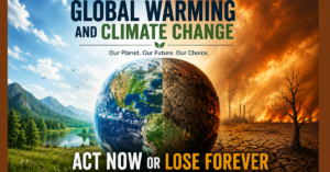
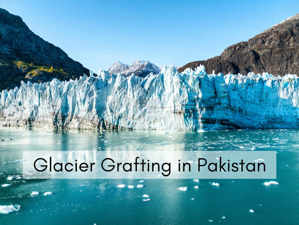
Glacier grafting is emerging as a life-saving adaptation strategy for mountain communities in Pakistan facing water scarcity due to glacial retreat. Glacier grafting has gained urgency in recent years as Pakistan’s natural glaciers—especially in Gilgit-Baltistan and Chitral are shrinking rapidly, leading to serious water shortages.
Climate Change and Glacier grafting
Pakistan has some of the world’s highest and most spectacular mountains. A total of 13 of the world’s 30 tallest peaks are located there, including K2 the second highest peak in the world, Nanga Parbat, the highest peak, and Tirich Mir in the Hindu Kush. The northern Pakistan is estimated to cover 15,00 km, and as much as 31 percent of the Karakoram region is covered by Glaciers that’s why Pakistan is considered home to over 7,000 glaciers, the highest number outside the polar regions.
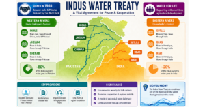
These glaciers feed the Indus River Basin, the primary water source for 90% of the country’s agriculture. Although, climate change is accelerating glacier melt. Research from the Pakistan Meteorological Department (PMD) shows that many small- and medium-sized glaciers in the Hindukush–Karakoram–Himalaya (HKH) region are retreating at rates never recorded before.
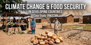
This loss directly affects remote villages that depend on timely spring meltwater for sowing crops. The melting of glaciers is also causing amplified erosion, flooding and landslides, which can be highly catastrophic and destructive and the local infrastructure and human lives are at risk. In areas like Skardu, Shigar, Ghazir, Astor and Hunza, delays in glacier melt now mean missed planting seasons, crop failures, and declining food security.
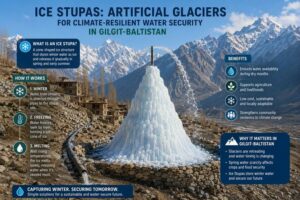
On one side Climate change results of melting glaciers while on the other conventional methods of glacier grafting can help in the rebirth of glaciers and it can be used as counter-mechanism for the glacier melting and water scarcity issue. In Gilgit Baltistan, all glaciers are not formed naturally but local and indigenous glaciers grafting practices have also contributed to the genesis of glaciers in the region. One of them is “Gang Khswa”, it is a Balti word (local language) which means “nourishes with deep love and affection.
Glacier Grafting and its methodology:
Glacier grafting in the local context of northern Pakistan—especially in Gilgit-Baltistan and Chitral are rooted in indigenous knowledge, traditional practices, and community collaboration, often passed down through generations. Here’s how the method typically works in practice:
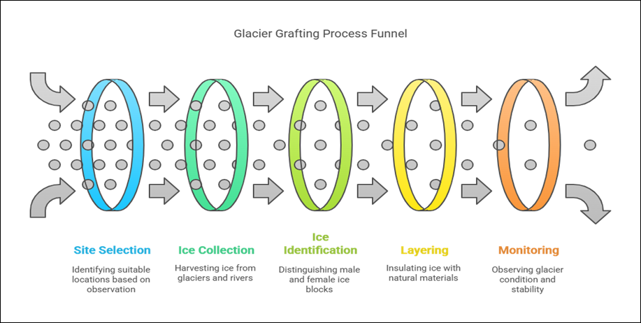
Local Site Selection through Observation
Community mobilization and site observation is a key part of the traditional glacier grafting process in Gilgit-Baltistan and Chitral. Villagers rely on their lifelong experiences and deep understanding of the local environment to choose the right location. They observe snow behavior, past glacier movement, and microclimatic patterns to identify ideal sites.
These are usually found at elevations of 12,000 to 14,000 feet above the village. The locations contain rocky hollows or basins that may retain snow and ice, are naturally sheltered, and face north to reduce exposure to sunshine. All of this is carried out without the use of contemporary tools. The site’s suitability is ensured solely via generational wisdom, careful observation, and traditional understanding.
Ice Collection by Community Teams
Small parties, mainly made up of young men from the hamlet, go to neighboring glaciers, frozen rivers, or snow-covered scree slopes to harvest ice during the coldest months of the year, which are usually December to February, when the ice is most stable and accessible. In some cases, they also collect remnant ice from melting zones of older glaciers. The ice is manually cut using simple tools like axes, spades, or even wooden instruments.
Once collected, it is carefully transported to the glacier grafting site using traditional means—such as baskets carried on the back, wooden sleds, or with the help of donkeys or mules, depending on the terrain. This labor-intensive process reflects the community’s commitment to sustaining water access through locally driven methods.
Identification of female ice (Mo-gang) and male ice (Pho-gang)
According to folklore, Glaciers are also given male and female identities, male glaciers are grey in colour, having a lot of debris, meanwhile female glaciers are shiny white or blue. Grafting a new glacier requires a piece each of a male and female glacier weighing approximately 35 kilograms. Villagers carefully pack these pieces in some coal and barley hay to keep them safe from warmer temperature and put them into a chorong (a conical basket made of willow twigs).
It was strongly considered if both the ice block were taken from a similar gender then neither the grafting will become successful, nor it will grow up properly. This cumbersome and laborious process that they went through in order to bring that both male and female ice are available for glacier grafting, was the most challenging part.
Layering with Natural Insulators
A vital stage in the glacier grafting procedure to guarantee the transplanted ice’s durability. When the villagers arrive at the chosen location, they start digging a shallow trench which must be two to three feet deep in order to hold the Ice. To increase volume and moisture, the harvested ice is placed in the basin and then covered with layers of snow, villagers use natural insulating materials like dirt, charcoal, wood ash, sawdust, and dried leaves to shield the ice from direct sunshine and quick melting. However, when the crops need water the most, these layers help keep the ice in place during winter and early spring.
No Machinery, Only Manual Labor
Labors are play important role in glacier grafting in Gilgit-Baltistan. Without the use of modern machinery, every stage of the process from ice harvesting, transportation to layering and site preparation are carried out entirely by human hands. Although, for sustainable, low carbon solution to water scarcity this manual approach not only supports with the realities of remote, off-grid mountain regions where access to technology is limited, but it also represents a sustainable, low-carbon solution to water scarcity. The reliance on local labor and traditional tools makes glacier grafting both cost-effective and environmentally friendly, ensuring that the technique can be replicated in other high-altitude communities without the need for external resources.
Seasonal Monitoring by Locals
After implementations of ice, the seasonal monitoring by locals are essential for glacier grafting. When the artificial glacier is installed, local elders, and other community members of the area are regularly travel and keep an eye on its condition of the glacier grafting. The villagers observe the accretion of snow, the stability of the ice layers, and signs of early melting. Consistent monitoring helps ensure the glacier continues to grow or remain intact through the season.
Due to the warm spell or windstorm the snow cover appears thin and damaged. So, villagers may return to the site especially after fresh snowfall to add more snow or reinforce the insulating layers. This hands-on, seasonal care allows the artificial glacier to survive until spring and continue supplying much-needed meltwater for crops and households.
Site Suitability Map for Glacier Grafting in Gilgit Division
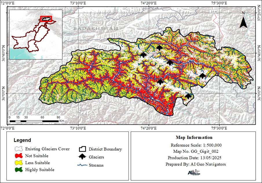
The Gilgit Division Site Suitability Map for Glacier Grafting provides a thorough spatial analysis of locations in Gilgit Division that are appropriate for the use of glacier grafting procedures. Based on its aptitude for glacier grafting, the map divides the topography of Gilgit Division—which includes the districts of Gilgit, Hunza, Nagar, and Ghizer—into three main zones: extremely appropriate, less suitable, and not suitable. Altitude, slope direction, closeness to existing glaciers, and availability of water sources like streams are among the environmental and geophysical elements that are evaluated to define these classifications.
Dark green-shaded areas are those that are best suited for glacier grafting. These areas usually have ideal circumstances for the creation and maintenance of artificial glaciers, such as north-facing, shaded slopes at heights exceeding 3,500 meters. Yellow regions are considered less favorable, where glacier grafting would still be possible but would be limited by the climate or the terrain. Red areas are designated as unsuitable, usually because of their lower elevations, unfavorable slope conditions, or absence of water flow and glacial influence.
Existing glaciers are visually highlighted in white on the map, and important glacier locations—which can be used as sources for ice harvest and transplantation—are indicated by black triangular symbols. The division’s natural stream network, shown by blue lines, is essential for directing meltwater from man-made glaciers to downstream residential and agricultural regions.
Gilgit Division’s administrative borders are well defined, and an inset map in the figure’s upper-left corner illustrates the division’s location inside Pakistan’s northern mountain range. The map supports focused interventions that improve climate resilience, sustainable water management, and livelihood stability throughout Gilgit Division’s high-altitude districts by pinpointing the best places for glacier grafting.
Glacier Grafting in Action: Different Case Studies from Gilgit-Baltistan
Glacier grafting has been implemented in a number of Gilgit-Baltistan locales because of their climatic and geographic appropriateness. Hussaini Village in Upper Hunza (Gojal), where people have been doing glacier grafting for generations, is one of the most well-known locations. Locals ensure a year-round supply of meltwater by harvesting ice from existing glaciers and relocating it to shady mountain gullies.
Another significant region that has seen both traditional endeavors and NGOs-supported initiatives is the Skardu Valley in Baltistan. Organizations like the Aga Khan Rural Support Programme (AKRSP) and WWF-Pakistan have conducted experimental glacier grafting programs in Skardu and the surrounding valleys. Bagrot Valley near Gilgit is another notable place where glacier grafting has been used to deal with the dwindling glacial meltwater supply.
The Barpu and Hoper Valleys in the Nagar District have also employed glacier grafting. These locations are often supported by development partners that assist with training, monitoring, and the selection of sites for artificial glacier generation. In the Khaplu and Shigar Valleys of Baltistan, glacier grafting is also required to maintain the water supply for agricultural and residential use.
In recent years, environmental organizations’ pilot programs have officially legitimized glacier grafting. WWF-Pakistan highlighted the achievements of glacier grafting initiatives in Tialli Village, Broq in Skardu, and Kharmang in its report on the 2021 pilot study. These efforts combined traditional techniques with scientific support to increase efficacy and scalability. Similarly, the 2019 AKRSP study on climate adaptation strategies in Baltistan emphasized glacier grafting as a community-based response to water stress.
Role of GIS in Glacier Grafting
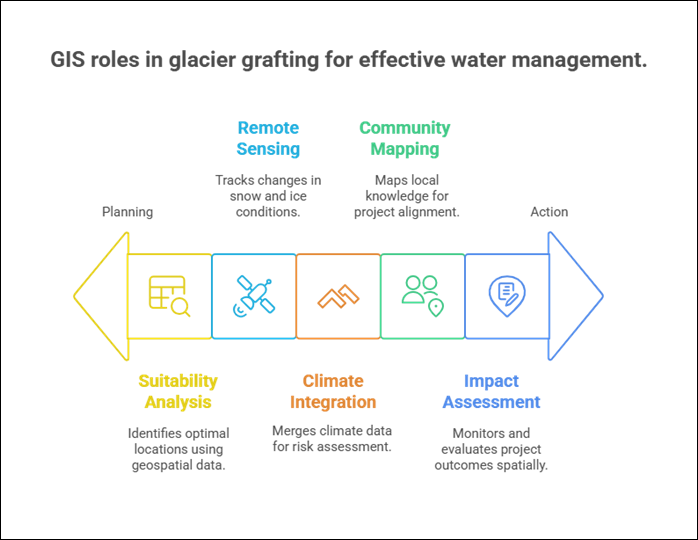
GIS (Geographic Information Systems) are essential for improving the planning and supervision of glacier grafting operations in areas such as Gilgit-Baltistan and Chitral. It helps identify the best locations for glacier grafting by looking at height, slope, aspect, and nearby water sources. Using satellite imagery to monitor snow cover, ice movement, and seasonal melting trends helps improve decision-making. GIS also uses climate data, including temperature and precipitation, to assess long-term threats. Moreover, mobile GIS technology allow local residents to map water sources and track changes, increasing accuracy and process participation. All things considered, glacier grafting in other regions is more successful, accurate, and repeatable when GIS is used. GIS technology adds scientific accuracy and long-term sustainability to glacier grafting, which has previously been a low-tech, community-led process. In Gilgit Baltistan, GIS has the following functions in glacier grafting.
1. Site Selection and Suitability Analysis
Given that it examines significant geographical aspects, GIS is crucial for identifying the ideal sites for glacier grafting. Factors such as elevation (preferably between 12,000 and 14,000 feet), drainage patterns, gradient (to help retain snow), slope aspect (ideally north-facing to limit sun exposure), and distance from existing glaciers or snowlines are always taken into account. These statistics may be superimposed on topographic maps and digital elevation models using GIS, which makes it possible to pinpoint attractive locations where artificial glaciers have the best chance of growing and effectively influencing rivers downstream.
2. Remote Sensing for Snow and Ice Monitoring
Remote sensing and GIS For continuous monitoring of snow and ice, remote sensing, assisted by GIS, employs satellite imagery from sensors such as MODIS, Landsat, and Sentinel-2. These methods are applied by teams to track seasonal variation in melting processes, the advance or retreat of glaciers and changes in snow cover over time. This continued monitoring is crucial to evaluate the ecosystem effects of glacier coupling work and for creating adaptive planning that can account for time-dependent changes in the local cryospheric conditions.
3. Hydrological and Climate Data Integration
Actual glacier grafting planning requires the combination of hydrological and climatic datasets, and here GIS systems prove to be a useful software. GIS supports the development of climate-risk maps by integrating data of the spread of glacial lakes, together with temperature anomalies, precipitation trends, and historical water flow rates. These results are particularly helpful in assessing zones vulnerable to glacial lake outburst flood (GLOF) hazards and constructing artificial glaciers resistant to extreme climate as well as favorable to auxiliary irrigation.
4. Community Mapping and Local Collaboration
Through participatory GIS (PGIS), community members can participate in glacier grafting efforts. Locals can compare satellite data with what they see on the ground, display traditional glacier locations, and point out important water sources and channels. As well as promoting community ownership and linking treatments to local knowledge, this local contribution enhances the precision of GIS analysis. By including local players, the project is not only more sustainable, more relevant, but also a contributor to collaborative climate resilience.
5. Monitoring and Impact Assessment
The detailed progression and results of glacier grafting can be monitored and assessed using GIS. Field workers can digitally map the extent of irrigation improvements, capture water availability information, and collect geotagged images through mobile GIS apps such as ArcGIS Collector and QField. It is this spatial recording that makes the comparison of pre- and post-intervention conditions, the measurement of benefits in particular locations and the generation of visualised reports to community stakeholders feasible. Additionally, the experience from GIS-based impact analysis is important to transfer the methodology to other areas.