Geographic Information System | What is Gis
A computer program called a Geographic Information System (GIS) links data and maps, It enables users to record, store, examine, and display geographic data. To put it simply, GIS aids in our comprehension of the location and characteristics of objects.
GIS is a potent decision-making tool that may be used in a variety of domains, such as city planning, disaster response, environmental protection, healthcare, and transportation, by fusing location with comprehensive data.
Brief History of GIS
The creation of the Canada Geographic Information System (CGIS) in the 1960s, which aided in planning and land inventory, gave rise to the idea of GIS. CGIS, a novel computer-based method for managing and interpreting spatial data, was started by geographer Roger Tomlinson.
GIS developed into a more potent and widely available tool as technology improved during the 1970s and 1980s, especially in the areas of computing, satellite photography, and GPS. These days, real-time navigation, environmental monitoring, and the creation of smart cities all depend heavily on it.
Five basic components of all GIS systems
There are Five essential elements are necessary for GIS to operate efficiently.
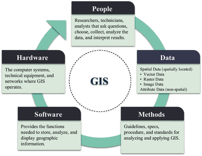
Hardware
Computers, GPS units, and storage are examples of GIS hardware. Data processing, analysis, and map display are all supported.
Software
GIS programs such as Google Earth Engine, ArcGIS, and QGIS facilitate the analysis and visualization of spatial data.
Data
The two most important types of data are attribute data (population, land use, temperature) and spatial data (road, building, and river locations).
People
Analysts, planners, developers, and other GIS specialists use the system to solve issues and make choices.
Methods
These procedures and workflows guarantee precise, reliable, and significant outcomes. This covers the procedures for gathering, evaluating, and disseminating data.
Together, these components transform unprocessed spatial data into insights that are valuable to various sectors.
Types of GIS Models
GIS represents spatial information using two primary data model types:
Vector Data Model
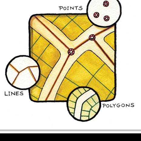
The vector model uses polygons for regions like parks or buildings, lines for highways, and points for places like schools or hospitals to express certain qualities. When high accuracy is required, like in road networks or urban planning, it works very well.
Raster Data Model
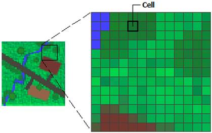
This model uses grid cells or pixels to represent continuous data, such temperature, height, or rainfall. It is frequently used in climate and environmental research because of its ability to record small changes over time.
Every model has advantages. Whereas raster data is excellent for surface studies such as pollution levels or vegetation health, vector data is accurate and helpful for infrastructure and borders.
Applications of GIS
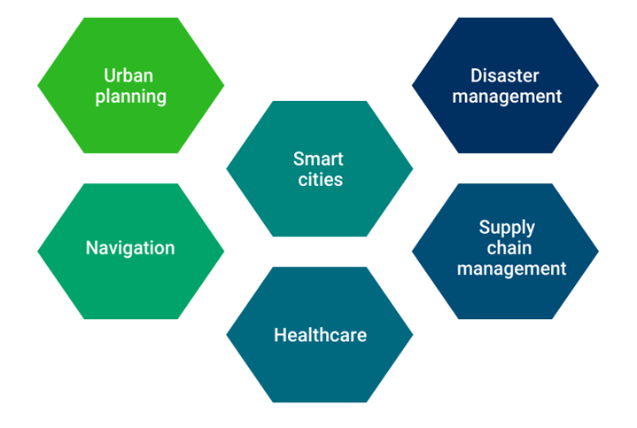
Urban Planning
GIS aids in the analysis of land use patterns, traffic flow, and population density by urban planners. It helps direct choices on the locations of roadways, schools, and parks by visualizing the connections between different elements. Additionally, GIS makes it possible to simulate potential future developments, which improves strategic planning.
Smart Cities
The management of smart cities depends on GIS. It assists municipal administrators in making decisions in real time by combining data from several sources, including public services, energy, and transportation. For instance, GIS and IoT sensors can be used to track water use, street lighting, and rubbish collection.
Disaster Management
GIS aids in the mapping of danger areas, the development of evacuation routes, and the coordination of relief activities during crises like earthquakes or floods. In order to monitor the effects of disasters and organize efficient responses, it gathers data in real time from satellites, sensors, and meteorological systems.
Navigation and Transportation
By merging maps with GPS and traffic information, GIS enables navigation applications. It assists users in exploring nearby locations, avoiding traffic, and determining the quickest or safest route. It also affects transportation planning and logistics.
Healthcare
GIS aids in planning immunization campaigns, tracking illness outbreaks, and keeping an eye on hospital capacity. During public health emergencies, it can assist in more efficient resource allocation and highlight locations with inadequate health services.
Supply Chain Management
Companies use GIS to arrange warehouses, track shipment movements, and expedite delivery routes. GIS reduces fuel expenses and improves delivery efficiency through route planning and traffic and weather analysis.
Future Trends in GIS
Technological Advancements
With the advent of cloud computing, the Internet of Things (IoT), and artificial intelligence (AI), GIS is developing quickly. AI facilitates the analysis, pattern recognition, and future outcome prediction of big datasets. IoT makes it possible for GIS to get real-time data from sensors in domains like smart agriculture and disaster monitoring. Globally, cloud platforms increase the accessibility and scalability of GIS products.
Data Integration
ERP (Enterprise Resource Planning), BIM (Building Information Modeling), and big data analytics are just a few of the systems that modern GIS integrates with. Users can examine intricate connections, such as the relationship between illness transmission, population density, and transportation accessibility, thanks to this integration.
Improved Accessibility
The GIS platforms of today are getting easier to use. Web-based GIS tools have made it possible for even non-experts to generate dashboards, analyze data, and create maps. Participatory GIS and citizen science enable individuals to add local expertise to initiatives, fostering more inclusivity and community involvement.
Why GIS Matters
GIS is becoming more than just a tool for creating maps, it combines technology, human knowledge, and data to help solve real-world problems. From building safer cities to managing forests and enhancing healthcare, GIS enables smarter decisions through spatial awareness. It promotes cross-sector cooperation and aids in addressing major issues like resource management, catastrophe resilience, and climate change.
Conclusion
Our understanding and management of the world have been altered by Geographic Information Systems (GIS). GIS enables us to identify trends, resolve issues, and reach well-informed conclusions by merging data and maps. GIS’s fundamental elements like, hardware, software, data, people, and methods which support a broad range of applications, from environmental preservation to urban development. GIS is becoming more potent, accessible, and essential to our future as it develops further with AI, IoT, and cloud technologies. GIS has something useful to give everyone, whether they are scientists, planners, entrepreneurs, or citizens.