Geospatial surveying is a powerful way to collect and analyze location-based data to map land, infrastructure, and natural features. It plays a key role in industries like construction, urban planning, agriculture, and environmental monitoring.
This article explains what is geospatial surveying, how its works, the main types of surveying methods, the top tools and GIS software used, and where it’s applied in the real world.
We’ll also explore how advanced gis companies in Pakistan like AI Geo Navigator are using artificial intelligence in geospatial technology to make surveying faster, smarter, and more accurate. Lets get started.
What is Geospatial Surveying?
The term geospatial surveying encompasses the gathering, processing, and examination of data linked to geographic locations. Geospatial surveying, in contrast to conventional surveying that concentrates on measurements at ground level, employs a mix of satellite imagery, aerial photography, GPS, GIS, LiDAR, and remote sensing to produce precise spatial representations.
Geospatial surveying is an essential discipline that lies at the crossroads of geography, technology, and engineering. It entails accurately measuring and analyzing the Earth’s surface with sophisticated tools and methods to collect, interpret, and display spatial data.
Need Advanced GIS Solutions? Let’s Build Your Project Together
Contact usHow Does GIS Geospatial Surveying Work?
Data Collection
This is the fundamental phase in which spatial and attribute data are gathered with different surveying instruments:
- GPS/GNSS Surveying
- Total Station
- Drones
- LIDAR
- Photogrammetry
- Traditional Land Surveying
Data Processing
Once raw data is gathered, it is converted into usable formats. GPS data is converted into coordinates, images are georeferenced, cleaned, filtered and adjusted for errors and then converted into vector layers and raster datasets.
GIS Integration
Once the data has been processed, it is imported into GIS platforms such as ArcGIS, QGIS, or GeoServer. This phase entails storing data in databases, linking spatial features to attributes and then overlaying multiple layers for spatial analysis
Analysis and Visualization
GIS software enables complex geospatial analysis, including topographic analysis, hydrological modelling site suitability analysis buffering & proximity, change detection and so on.
Decision-Making and Application
Decision-making in many areas is supported by GIS geospatial surveying like urban planning, disaster management, environmental monitoring, infrastructure development, agriculture and forestry mining and geological studies.
Types of Geospatial Surveying
Ground-Based Surveying
Ground-based surveying is a method employed to collect data about the Earth’s surface, encompassing its topography, natural and artificial features, as well as the subsurface. This encompasses the measurement of an area’s dimensions, which includes distances, directions, angles, and elevations. Below are types of ground-based surveying.
Total Station Surveying
It combines electronic distance measurement (EDM) with angular measurement and it is useful for construction layout, topographic mapping, and boundary surveys.
GPS/GNSS Surveying
It uses satellite systems to determine precise locations. It is used for control points, mapping and geodetic surveys.
Theodolite Surveying
It measures horizontal and vertical angles. It is traditional land surveying method.
Leveling Survey
It measures height differences (elevation) between points using levels and staff.
Aerial Surveying
Aerial surveying entails gathering information about a region from above, usually with the aid of aircraft or drones. This process can serve multiple functions, including mapping, environmental oversight, and infrastructure development. The following are types of aerial surveying.
Drone (UAV) Surveying
It captures aerial imagery using UAVs. It can be used for photogrammetry, 3D modeling, and monitoring.
Aerial Photogrammetry
It derives 3D data and maps from overlapping aerial photographs and is useful for topographic mapping, land cover classification and urban planning.
Remote Sensing-Based Surveying
Remote sensing-based surveying entails gathering data about a region from afar, usually employing technologies such as satellites, drones, and LiDAR. This technology enables the mapping of extensive or hard-to-reach regions with great precision and effectiveness, transforming conventional surveying techniques. The following are types of remote sensing-basedsurveying.
Satellite Remote Sensing
It involves usage of satellite imagery to gather large-scale spatial data.
LIDAR Surveying
It uses laser pulses to measure distances and create high-resolution 3D models and is used for forest canopy analysis, floodplain mapping and urban modeling.
Radar Surveying
It uses radar to detect ground deformation over time. It is use for landslide monitoring, subsidence detection and tectonic studies.
Hydrographic Surveying
It maps underwater terrain using sonar. This information is vital for a range of applications, such as safe navigation, marine construction, and resource exploration.
Cadastral Surveying
Cadastral surveying, a specialized area within land surveying, concentrates on determining and documenting the boundaries of land parcels, which encompasses property lines and measurements. For legal reasons, land management, and taxation, it is essential. Cadastral surveys aid in the creation and upkeep of clear and precise property records.
Surveying Software and Tools
Here is a thorough compilation of GIS surveying software and tools, organized according to their main functions, ranging from gathering field data to processing, analyzing, and visualizing:
Mobile Apps & GNSS Tools
- ArcGIS Field Maps
- Survey123 for ArcGIS
- Mappt
- SW Maps
- Collector for ArcGIS
Desktop GIS Software
- QGIS
- ArcGIS Pro / ArcMap
- Global Mapper
- MapInfo Professional
- AutoCAD Map 3D
Remote Sensing & Photogrammetry Software
- Software
- Pix4DmapperAgisoft MetashapeENVI
- ERDAS IMAGINE
GPS/GNSS Data Processing Software
- Trimble Business Center
- Leica Geo Office
- Topcon Magnet Tools
Specialized Tools for Surveying and Analysis
- GRASS GIS
- SAGA GIS
- FME
- PostGIS
Applications of Geospatial surveying
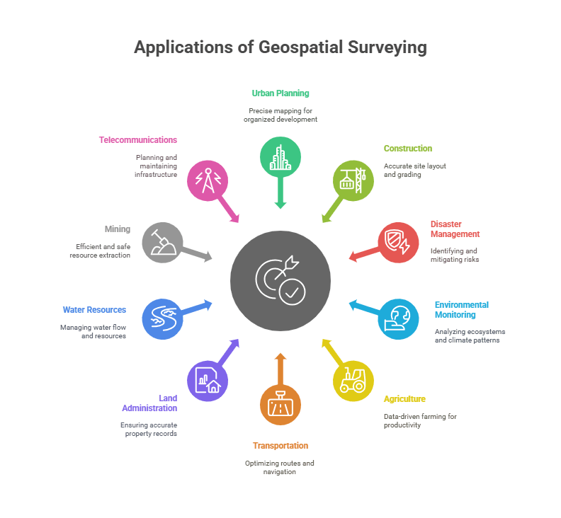
Below are the key applications of geospatial surveying, categorized by industry:
1. Urban Planning and Infrastructure Development
By means of land parcel mapping and zoning, planners can precisely delineate property boundaries, categorize land uses, and oversee legal ownership records, thus ensuring development is organized and lawful. It also plays a crucial role in the design and planning of roads, bridges, and utilities, offering detailed insights into terrain, existing infrastructure, and environmental limitations.
Geospatial surveying provides authorities with the capability to observe urban sprawl, identify unplanned growth, land encroachment, and alterations in land use patterns as time progresses. This enables improved regulation, sustainable advancement, and conservation of green areas.
2. Construction and Civil Engineering
Geospatial surveying data plays a vital role in site layout and grading by helping to determine precise ground levels and locations for structures, which is essential for appropriate drainage and foundation stability. Drones, GPS, and GIS-based platforms are employed in construction progress monitoring to track developments in real time.
Moreover, geospatial surveying is crucial for calculating earthwork volumes, offering precise measurements of soil excavation and filling. Lastly, utility mapping from geospatial survey data is vital for pinpointing the positions of water lines, sewer systems, and electrical networks.
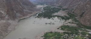
3. Disaster Management & Risk Assessment
Survey data, when combined with elevation models and rainfall records, assists in identifying flood-prone areas through flood modelling and hazard mapping. This facilitates early warnings and the development of mitigation strategies. In the same way, analysis of landslide risk utilizes information about the terrain, gradients of slope, types of soil, and patterns of precipitation to evaluate regions that are susceptible to landslides; this supports officials in taking preventive measures.
Geospatial tools assist in evaluating damage after a disaster by comparing satellite or drone images taken before and after the event. This helps quickly assess the damage extent, prioritize response actions, and facilitate insurance claims.
4. Environmental Monitoring
Geospatial surveying is useful in the analysis of forest cover and deforestation over time, identify illegal logging activities, and evaluate the health of forest ecosystems. It is essential for wildlife habitat mapping, as it helps to identify and safeguard vital habitats, monitor animal movements, and design conservation corridors that promote biodiversity.
It also helps to analyze changing climate patterns, glacial retreat, sea-level rise, and land degradation. Moreover, management of wetlands and watersheds employs elevation models, hydrological data, and land use patterns to track water flow, avert pollution, and guarantee sustainable utilization of water resources.
5. Agriculture and Precision Farming
Geospatial surveying has transformed agriculture, enabling farmers to make data-driven decisions that enhance productivity and sustainability. Utilizing this data, soil mapping and fertility zoning assess soil types, nutrient levels, and pH variations throughout fields. This facilitates site-specific fertilizer application and improved crop planning.
Crop health monitoring, which often utilizes NDVI (Normalized Difference Vegetation Index) from drone images, aids in the early detection of plant stress. Terrain analysis and soil moisture data from this surveying enhance irrigation planning by informing the design of effective water distribution systems and aiding in the optimization of irrigation schedules for water conservation.
6. Transportation and Navigation
Geospatial surveying greatly improves route optimization and planning leverage real-time spatial data, traffic conditions, and terrain analysis to identify the most efficient routes for logistics, public transit, and emergency services, thereby reducing travel time and fuel consumption.
Precise mapping of railway and road networks guarantees current infrastructure data for maintenance, planning of expansions, and incorporation into navigation systems. Moreover, the navigation of autonomous vehicles relies significantly on high-resolution geospatial information and real-time environmental sensing to navigate self-driving cars safely through intricate road systems.
7. Land Administration & Cadastral Mapping
Property boundary demarcation guarantees accurate mapping of land parcels, a necessity for legal documentation, taxation, and development planning. Land tenure and ownership registration utilize GIS-based cadastral systems to keep ownership records current, thereby enabling secure land transactions and minimizing fraud.
Additionally, geospatial data is essential for legal land dispute resolution, as it offers clear and verifiable evidence of boundaries and ownership, aiding authorities in making equitable and informed choices.
8. Water Resources and Hydrology
Watershed delineation employs elevation and terrain data to identify drainage areas, essential for managing water flow and resources and results in floodplain mapping which designates regions vulnerable to flooding, aiding in risk evaluation and disaster readiness.
In the context of drainage system design, geospatial data is essential for planning effective channels and infrastructure to manage surface water. Moreover, groundwater potential mapping examines soil, rock, and recharge data to identify and sustainably manage underground water resources, aiding agriculture, drinking water supply, and ecosystem health.
9. Mining and Geology
Geospatial surveying ensures resource extraction is efficient and safe. Exploration and site modeling depend on spatial data to locate mineral deposits and develop detailed 3D representations of mining sites. Volume calculation of excavated material aids in the precise estimation of extracted resources, which is crucial for planning and cost management.
Geological mapping employs remote sensing and GIS to examine rock formations, faults, and the distribution of minerals.
10. Telecommunications & Utilities
It derives significant advantages from geospatial surveying in planning, installation, and maintenance activities. Telecom tower placement and signal mapping utilize elevation data, population density metrics, and terrain analysis to pinpoint ideal tower locations and guarantee robust, extensive signal coverage. Geospatial tools are utilized to identify the most effective and secure routes for routing electric and gas pipelines by examining land use, slope, and environmental limitations.
Moreover, underground utility detection utilizes GIS and ground-penetrating data for precise mapping of current water, sewer, and power lines, thereby minimizing the likelihood of construction-related damage and enhancing infrastructure management.
Advantages of geospatial surveying
Geospatial surveying provides high accuracy and precision, which allows for detailed mapping and reliable measurements. It facilitates real-time data collection and offers rapid, large-area coverage, which makes it suitable for projects that are both large-scale and time-critical.
Although the setup can incur high costs, it becomes cost-effective over time by minimizing fieldwork and errors. The technology enables improved visualization, smooth integration with AI, IoT, and BIM, and promotes sustainable development via more intelligent management of land and resources.
Additionally, it enhances safety by reducing risks at the location of operation, allows for time-series monitoring, and fosters data-driven decision making in multiple sectors.
Here are 4 unique and less commonly discussed advantages of geospatial surveying.
Predictive Maintenance and Infrastructure Resilience Planning
Geospatial surveying isn’t just about mapping; it plays a critical role in anticipating failures in infrastructure before they occur. By continuously monitoring spatial changes in roads, bridges, pipelines, and buildings using tools like LiDAR, drones, and satellite imagery, geospatial surveys help engineers detect subtle deformations or subsidence.
This allows organizations to plan predictive maintenance schedules instead of reacting after damage occurs. The long-term cost savings, enhanced safety, and reduced downtime make it an underappreciated yet powerful application in asset management and civil engineering.
Micro-Zonation for Disaster Risk Reduction
One of the lesser-known but powerful advantages of geospatial surveying is its ability to support micro-zonation—the division of land into very fine spatial units based on geological, hydrological, and demographic risk factors. This technique allows authorities to design highly targeted disaster response and mitigation plans.
For instance, in seismic-prone zones, micro-zonation can help identify blocks or even individual plots most at risk, guiding stricter building codes or early-warning systems at hyper-local levels. This kind of precision is only possible through detailed geospatial data capture and analysis.
Enabling Smart Sensor Networks for Real-Time Decision Making
With the growing adoption of IoT, geospatial surveys are critical in strategically deploying smart sensors across cities and landscapes. Sensor placement for air quality, noise levels, water flow, or structural health monitoring requires highly accurate geospatial baselines to ensure coverage, calibration, and signal integrity.
The advantage is not just mapping sensor locations, but optimizing their placement to feed meaningful real-time data into smart city systems. This synergy between geospatial and IoT technologies enables dynamic decision-making for utilities, traffic control, or public safety.
Supporting Digital Twins for Large-Scale Land and Utility Management
Digital twins, virtual replicas of physical systems are becoming essential in managing complex urban environments, utilities, and infrastructure. Geospatial surveying provides the 3D spatial backbone needed to construct and update these digital twins.
Unlike simple maps or CAD drawings, digital twins require precise topographic and geospatial input from UAV-based photogrammetry, terrestrial laser scanning, or multispectral imaging. The advantage lies in operational simulation: city managers can test scenarios like traffic rerouting, flood simulations, or utility failures in a virtual environment before acting in the real world.
How AI Geo Navigator can help in Geospatial Surveying?
“AI Geo Navigator” as a company blending Artificial Intelligence with Geospatial Surveying can offer cutting-edge solutions that significantly enhance the accuracy, speed, and intelligence of spatial data collection and analysis. AI Geo Navigator can help in;
- Automated Feature Extraction
- Smart Remote Sensing & Image Analysis
- AI-Powered Survey Planning & Optimization
- Intelligent Data Integration
- Predictive Analytics for Spatial Planning
- Real-Time Geospatial Dashboards
- Custom AI Models for Clients
- Cloud-Based GIS & AI Integration