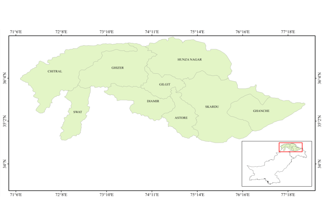
The region of Gilgit-Baltistan, Swat, and Chitral Pakistan is highly vulnerable to natural hazards including landslides, flash floods, and seismic activity due to its rugged terrain, fragile geology, and changing climate. As communities continue to expand in these high-risk zones, the need for safe, sustainable housing has become increasingly urgent. the application of geo-spatial technologies , particularly remote sensing and Geographic Information Systems (GIS), to identify suitable, disaster-resilient sites for housing construction in the Gilgit Baltistan region, a core part of Pakistan Hindu Kush Himalaya By combining satellite imagery, slope and elevation models, and multi-hazard risk maps, the initiative provides evidence-based guidance for site selection, minimizing exposure to natural hazards. This approach not only ensures safer settlements but also integrates local knowledge and environmental sustainability, supporting long-term resilience for mountain communities.
How to Collect Data for Housing Planning Using GIS and Remote Sensing in Gilgit-Baltistan, Swat, and Chitral?
The foundation of housing planning in Gilgit-Baltistan, Swat, and Chitral relies on the systematic collection of both spatial and non-spatial data to ensure accurate hazard assessment and site selection. Combination of remote sensing datasets, GIS layers, and community-sourced information to capture the full range of environmental and socio-economic variables influencing housing safety.
1. Remote Sensing Data
High-resolution satellite imagery is used to map land cover, vegetation, water bodies, and settlement patterns. Digital Elevation Models (DEM) including products derived from drone surveys and global datasets are collected to analyze slope, elevation, and terrain stability. Multi-temporal imagery helps detect seasonal changes and historical hazard events such as landslides and flooding.
2. Hazard-Specific Datasets
- Landslide susceptibility maps generated from slope, geology, and rainfall correlations.
- Floodplain and river buffer maps derived from hydrological modeling and historical flood records.
- Seismic fault line overlays from geological surveys to identify earthquake-prone zones.
- Glacial Lake Outburst Flood (GLOF) risk areas from glacier monitoring data.
3. Climatic and Environmental Data
Climatic and environmental data play a critical role in housing planning for Gilgit-Baltistan, Swat, and Chitral, where extreme weather events and fragile ecosystems directly influence settlement safety. This dataset helps assess long-term hazard risks, seasonal vulnerabilities, and environmental constraints that must be considered before construction.
- Meteorological Records
Historical and real-time weather data from the Pakistan Meteorological Department (PMD) and other sources are used to analyze temperature variations, precipitation trends, and extreme weather frequency. These records help identify areas susceptible to heavy rainfall, snow accumulation, or drought conditions. - Rainfall and Snowfall Patterns
High-resolution rainfall intensity maps and snowfall distribution data are collected to understand seasonal hydrological cycles. This is crucial for floodplain mapping, assessing flash flood risk, and designing effective drainage systems. - Climate Change Indicators
Long-term climate models and trend analyses highlight shifts in seasonal patterns, glacial melt rates, and changes in precipitation behavior. These indicators are essential for projecting future hazard scenarios, such as increased glacial lake outburst flood (GLOF) events. - Environmental Sensitivity Mapping
Remote sensing tools are used to monitor vegetation cover, deforestation rates, soil erosion, and water body dynamics. These environmental variables influence slope stability, flood absorption capacity, and the overall resilience of housing sites. - Glacier and Hydrology Monitoring
Data from glacier monitoring programs and river flow measurements help identify upstream water risks that can impact downstream settlements. This information is critical in areas dependent on glacial meltwater.
By integrating climatic and environmental datasets into the GIS-based planning process, housing site selection becomes more adaptive to both current and future environmental conditions, ensuring long-term safety, resilience, and sustainability for communities in the region.
4. Socio-Economic and Infrastructure Data
Socio-economic and infrastructure data are essential for ensuring that housing planning in Gilgit-Baltistan, Swat, and Chitral addresses not only safety from hazards but also accessibility, functionality, and the well-being of residents. Integrating these datasets into GIS analysis ensures that selected housing sites meet both risk reduction and livelihood needs.
- Population and Demographic Data
Census data, household surveys, and demographic records are used to understand population density, household size, age distribution, and vulnerable groups. This helps prioritize housing projects for communities most at risk, such as low-income households, elderly populations, and those living in hazard-prone areas. - Land Ownership and Land Use Information
Land registry records and cadastral maps are collected to determine ownership rights, prevent land disputes, and assess the compatibility of proposed housing sites with existing land use patterns. - Access to Essential Services
GIS mapping includes the location and proximity of roads, bridges, schools, health facilities, markets, and water supply points. This ensures that housing sites are not only safe but also well-connected to critical services and economic opportunities. - Economic Activity and Livelihood Data
Information on local industries, agriculture zones, tourism hubs, and employment centers is used to select sites that support residents’ income-generating activities, reducing displacement from livelihood sources. - Existing Infrastructure Condition
Surveys and satellite imagery help evaluate the current condition of infrastructure such as roads, drainage systems, and utilities. This allows planners to assess upgrade requirements or potential integration with the proposed housing development.
Land use Land Cover (2025) of Gilgit-Baltistan, Swat, and Chitral, Pakistan
The Land Use Land Cover (2025) forms a critical input for the study GIS and Remote Sensing Applications for Housing Planning by identifying suitable and hazard-free zones for development. By mapping forests, agriculture, rangelands, barren lands, built-up areas, water bodies, and snow/ice cover, it helps planners avoid ecologically sensitive or disaster-prone areas while prioritizing stable and accessible sites. This spatial insight ensures that housing projects are sustainable, resilient, and aligned with both environmental conservation and community needs.
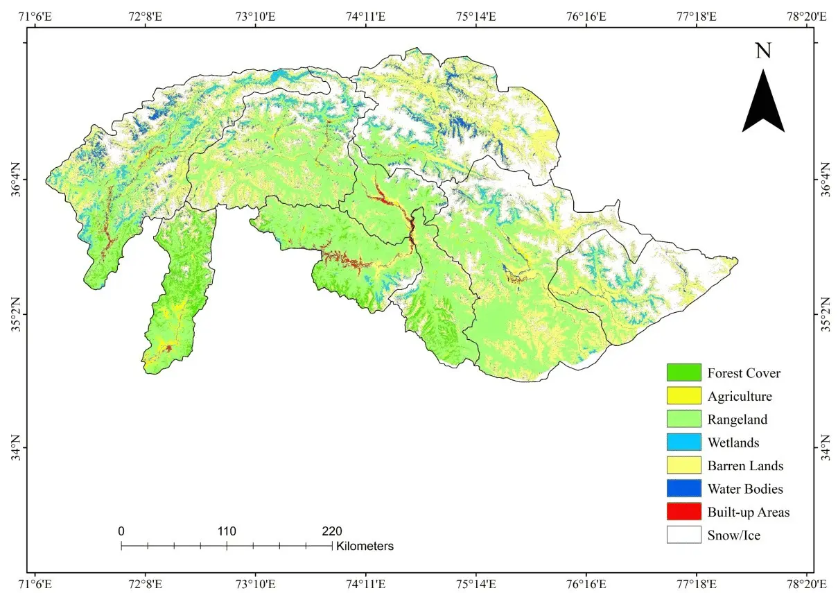
The map distinguishes different land cover types through color-coded classification.
Forest cover (shown in dark green) is concentrated in the mid- to high-altitude zones, particularly in parts of Swat and Chitral, playing a critical role in slope stabilization and ecosystem services.
Agriculture areas (light green) are found mainly in valley bottoms and river terraces, where fertile soils and irrigation make farming possible.
Rangelands (yellow) dominate large portions of the terrain, supporting grazing and seasonal livestock movement.
Wetlands (light blue) appear in scattered patches, often linked to glacial meltwater streams and high-altitude lakes.
Water bodies (deep blue) include major rivers and lakes that are vital for local livelihoods. Barren lands (tan) occupy rugged, high-altitude, or arid zones unsuitable for vegetation growth. Built-up areas (red) are relatively sparse and clustered in valleys and accessible lowlands, representing towns and villages.
Snow and ice (white) are prevalent in the highest peaks and glaciated zones, feeding the region’s hydrological systems. This land cover classification supports evidence-based planning for housing, agriculture, conservation, and hazard management by showing the spatial relationship between natural resources, human settlements, and environmental constraints.
Importance of Slope Analysis in Gilgit-Baltistan, Swat, and Chitral
Slope analysis is a critical component of housing planning in the mountainous terrains of Gilgit-Baltistan, Swat, and Chitral, where steep gradients significantly influence hazard risk and structural stability. In these regions, slopes between 30° and 40° are particularly prone to landslides, soil erosion, and rock fall events, posing severe threats to settlements.
Through GIS and Remote Sensing, DEM and DTM are used to classify terrain into gentle, moderate, and steep categories, enabling planners to avoid high-risk gradients. Selecting moderately sloped or gently inclined land not only reduces the likelihood of landslides but also lowers construction costs by minimizing the need for extensive earthworks or retaining structures.
Slope data, when integrated with other hazard layers such as proximity to rivers or fault lines, supports a multi-hazard assessment that guides risk-informed site selection. This evidence-based approach ensures that housing developments are structurally stable, climate-resilient, and aligned with long-term safety objectives in the Hindu Kush Himalaya region.

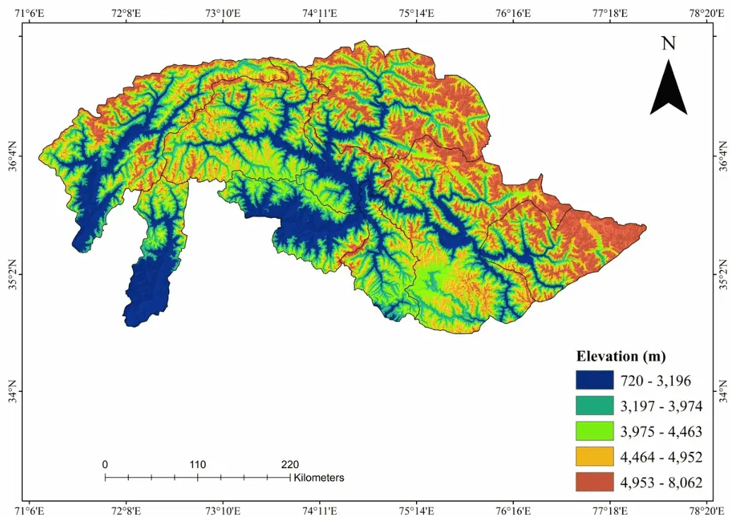
Importance of Elevation Analysis in Gilgit-Baltistan, Swat, and Chitral
The elevation map plays a crucial role in guiding risk-informed and climate resilient housing development. By visualizing altitude variations across the mountainous terrain, the map helps planners identify suitable locations for construction avoiding high-elevation zones vulnerable to snow accumulation, glacial lake outburst floods and landslides, as well as low lying valleys prone to flash floods.
Elevation data derived supports the selection of geologically stable, moderately sloped areas ideal for safe housing. It also informs climate-responsive design decisions, such as insulation and roof structure, based on the temperature and exposure levels associated with different elevation bands.
Overall, the GIS and Remote Sensing Applications for Housing Planning demonstrated that integrating geo-spatial technology with community engagement can produce safe, sustainable, and resilient housing solutions that are adaptable to other mountainous regions. The tangible outcomes safer settlements, empowered communities, and reduced environmental vulnerability serve as a model for climate-resilient infrastructure development.


