In the context of today’s rapidly advancing technological environment, GIS have emerged as crucial instruments in numerous domains, architecture included. As urban areas expand and the significance of sustainability escalates, architects are required to design with a more profound comprehension of environmental factors, community requirements, and spatial dynamics.
GIS enables architects to incorporate geographic data into their workflows, leading to designs that are more intelligent, responsive, and aware of their context.
This chapter offers a thorough examination of how Geographic Information Systems (GIS) are utilized and their advantages in architecture. It examines how GIS technology aids architectural design, planning, analysis, and decision-making through a range of spatial data management and visualization methods.
What is GIS?
Geographic Information Systems (GIS) are systems that collect, store, analyze, and visualize spatial or geographic data. GIS aids in comprehending patterns, relationships, and trends within geographic space by utilizing layers of information that include topography, land use, hydrology, infrastructure, and demographics.
In short, GIS connects data with geography. GIS provides a robust foundation for location-based decision-making, whether it involves mapping the natural surroundings or the constructed environment.
How Does GIS Apply to Architecture? And How It Helps?
GIS plays a vital role in architectural planning and design by offering tools to:
- Analyses site suitability by examining land characteristics, gradient, soil category, flood-prone areas, and accessibility.
- Holds contexts like acquiring knowledge about the surrounding infrastructure, social dynamics, heritage locations, and urban layout.
- Promotes sustainability by determining eco-friendly infrastructure, maximizing land utilization, and minimizing ecological effects.
- Assists urban design by aiding in the visualization of public areas, transport systems, and interconnections among structures at the scale of a city.
GIS enables architects to base their decisions on data in the initial planning phases, which helps guarantee that designs are sensitive to context, economical, and consistent with social and environmental objectives.
Applications of GIS for Architecture
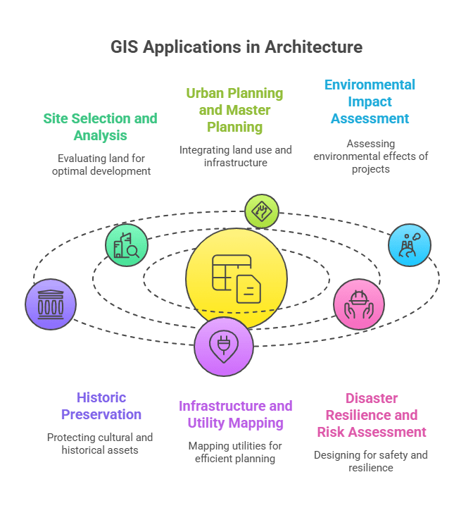
In architecture, GIS stands for a tool that helps architects integrate spatial data into designs for better-informed and contextually relevant structures. GIS has many practical uses in architecture. By integrating spatial and geographic data, architects utilize GIS to analyze site conditions, plan urban spaces, assess environmental impacts, and design sustainable buildings.
This simplifies decision-making for planners and enriches plans with better visuals and deeper insights.
Looking for smart GIS solutions to support your architectural projects?
Contact usSite Selection and Analysis
Before the start of design work, GIS aids architects in selecting the optimal site by evaluating factors such as land slope, proximity to roads and utilities, likelihood of flooding, and zoning limitations, environmental restrictions, ensuring sustainable development.
Some examples include land suitability analysis, accessibility and connectivity, environmental constraints and opportunities, infrastructure availability and cost estimation and feasibility.
Urban Planning and Master Planning
GIS enables the integration of land use, transportation, green spaces, and public services for large-scale planning. It helps to visualize the current infrastructure and anticipate future development needs.
Land Use Planning, Infrastructure and Transportation Planning, Population and Demographic Analysis, Urban Growth Monitoring, Utility and Service Planning and Environmental Planning are all included in urban planning with the help of GIS.
Environmental Impact Assessment
Architects can leverage GIS to evaluate the possible impact of a proposed structure on the local environment, encompassing aspects such as loss of vegetation, water runoff, and energy consumption. GIS enables architects engaged in EIA to fuse creative design with a sense of environmental accountability.
It enables the early identification of possible environmental disputes and contributes to the formation of development that adheres to legal standards and is environmentally sustainable.
Some GIS applications in this domain include baseline environmental mapping, impact zone buffering, slope and elevation analysis, hydrology & drainage mapping, air, noise, and visual impact analysis, habitat and biodiversity assessment and cumulative impact analysis.
Historic Preservation
In the field of Historic Preservation, GIS is essential for architects to find, document, examine, and safeguard cultural and historical assets. GIS for architects goes beyond being a mere mapping tool; it serves as a strategic resource for planning interventions that honor and amplify heritage value.
GIS helps in cultural landscape analysis, change detection and monitoring, historic district planning, disaster risk assessment for heritage sites and restoration and adaptive reuse planning.
Infrastructure and Utility Mapping
For architectural planning, mapping of infrastructure and utilities based on GIS is essential. It guarantees that your designs are aware of their context, constructed safely, and serviced efficiently. GIS facilitates informed and integrated planning, whether it involves siting a new residential area, redesigning a historic district, or planning a new industrial zone. GIS maps both underground and above-ground infrastructure, from power lines to water mains, to ensure safe and efficient building integration.
Real-time monitoring of utilities using IOT/sensor data, outage and fault tracking, underground water, gas, and electrical lines, future expansion routes for pipelines and roads are all applications of GIS in this domain.
Disaster Resilience and Risk Assessment
The use of GIS for Disaster Resilience and Risk Assessment is essential for architects, and emergency managers to create environments that are safer and more adaptive. It centres on comprehending weaknesses, forecasting dangers, and creating infrastructure that can withstand disasters. In areas prone to natural hazards like floods or earthquakes, GIS helps in designing buildings that are resilient and located in safer zones.
GIS helps in hazard mapping, vulnerability assessment, risk zoning and site selection, resilient design planning, evacuation route and shelter planning and post-disaster assessment and reconstruction.
GIS Tools for Architects
GIS tools for architects include various software and technologies aimed at gathering, analyzing, visualizing, and organizing spatial data pertinent to architectural projects. With these tools, architects can incorporate geographic context into their designs, conduct site analyses, evaluate environmental effects, and enhance planning choices. Several GIS platforms and tools are especially useful for architects:
- QGIS
- PostGIS
- CityEngine
- Google Earth Pro
- AutoCAD Map 3D
- MapInfo Professional
- Autodesk InfraWorks
- Revit with GIS Integration
- SketchUp with GIS plugins
- ArcGIS Pro and ArcGIS Online
With these tools, tasks like site suitability analysis, environmental impact assessments, urban planning, infrastructure mapping, and 3D terrain modeling become easier. This enhances the architect’s ability to create informed, sustainable, and context-sensitive designs.
Ai Geo Navigator GIS Services for Architectural Planning
For complex projects or firms, professional GIS services offer:
Spatial analysis
The examination of the locations, attributes, and relationships of features in spatial data using techniques such as overlay, buffering, proximity analysis, and pattern detection is referred to as spatial analysis in GIS. It aids architects, planners, and researchers in comprehending spatial patterns, trends, and interactions within a geographic framework.
Professionals can enhance planning accuracy and problem-solving capabilities by analyzing spatial data to make informed decisions about land use, resource allocation, environmental impact, and urban development.
Site suitability analysis
The process of using GIS for site suitability analysis entails assessing and pinpointing optimal locations for designated uses based on an examination of various spatial factors, including topography, land use, soil characteristics, resource accessibility, infrastructure availability, and environmental limitations.
GIS combines and analyzes these varied datasets to create suitability maps that assist planners, architects, and decision-makers in selecting the best locations for development, agricultural activities, conservation efforts, or infrastructure projects.
By aligning the characteristics of the site with project requirements and regulatory guidelines, this analysis enhances efficiency, mitigates risks, and promotes sustainable land use.
Urban Planning
The use of GIS in urban planning encompasses the examination, design, and administration of urban areas through the integration of geographic data to facilitate sustainable and effective development.
With the aid of GIS, planners can visualize land use patterns, infrastructure, transportation networks, and demographic data, which facilitates informed decision-making regarding zoning, resource allocation, and growth management.
It facilitates scenario modeling, impact assessments, and public engagement through interactive maps and spatial analyses that uncover potential challenges and opportunities in urban environments. Ultimately, GIS contributes to urban planning by fostering data-driven approaches that enhance livability, environmental sustainability, and economic vitality in cities.
Map production
The creation of maps in GIS entails producing detailed, precise, and attractive maps that depict spatial data for a range of uses, including planning, analysis, communication, and decision-making. The procedure encompasses gathering and integrating data, as well as symbolizing and labeling it, in addition to designing the layout.
The aim is to create maps that serve the purpose of effectively communicating geographic information. With GIS, users can automatically generate and customize maps, producing thematic, topographic, cadastral, or specialized maps designed to meet the needs of particular projects.
These maps are vital resources for architects, planners, engineers, and stakeholders to visualize spatial relationships, evaluate site conditions, and convey complex information clearly and efficiently.
Integration of GIS with BIM
By integrating GIS with BIM (Building Information Modeling), the advantages of geographic spatial data and detailed building design information are combined, allowing architects and engineers to plan, design, and manage construction projects more effectively.
While BIM delivers accurate 3D representations of buildings and their elements, GIS supplies the wider environmental and site context—like terrain, infrastructure, utilities, and zoning.
They collectively contribute to improved decision-making across a project’s lifecycle by enhancing spatial analysis, improving the coordination between site conditions and building design, optimizing resource allocation, and facilitating facility management.
By connecting macro-level urban planning with micro-level architectural details, this integration results in smarter and more sustainable developments.
Regulatory Mapping
GIS services in regulatory mapping assist architects, planners, and authorities in spatially managing and visualizing zoning laws, land-use regulations, building codes, and environmental restrictions.
GIS enables users to promptly ascertain applicable regulations for particular sites by superimposing regulatory limits onto maps, thus guaranteeing adherence during the phases of site selection, design, and development. This aids in making informed choices by emphasizing limitations like protected zones, flood zones, height limitations, and setback rules.
Moreover, regulatory mapping aids urban planning, permits processing, and public consultation by offering clear and accessible geographic information that aligns projects with legal frameworks and policy objectives.
3D terrain modelling
GIS services in 3D terrain modeling offer architects and planners vital tools for visualizing, analyzing, and comprehending the landscape to make informed decisions. Included in these services are the creation of high-resolution digital elevation models (DEMs), contour lines, slope and aspect maps, and 3D surface visualizations that assist in evaluating site suitability, earthwork volumes, drainage patterns, and visibility analysis.
GIS facilitates precise site selection, grading optimization, and landscape integration, while aiding environmental and hydrological evaluations by merging terrain data with CAD and BIM platforms.
These capabilities enhance project planning, lower construction costs, improve client communication through engaging visuals, and foster sustainable design by aligning built structures with natural landforms.
These services assist architectural firms in enhancing the quality of projects, minimizing design risk, and improving communication with stakeholders.
Conclusion
GIS for Architecture is not just a technological accessory; it is a transformative tool that reshapes architects’ approaches to design, planning, and engagement with the built environment. GIS promotes design outcomes that are more sustainable, resilient, and efficient by incorporating spatial intelligence into all stages of the architectural process.
GIS offers powerful and versatile tools that significantly enhance various aspects of architecture, urban planning, and environmental management. From 3D terrain modeling and regulatory mapping to integrating with BIM, spatial analysis, site suitability, and urban planning, GIS enables professionals to visualize, analyze, and manage spatial data effectively.
These applications improve decision-making by providing deeper insights into site conditions, environmental impacts, infrastructure, and regulatory constraints. Ultimately, GIS supports sustainable, efficient, and well-informed development practices that meet the complex demands of modern built environments.
With ongoing urbanization and escalating climate challenges, architects who utilize GIS will be more prepared to spearhead the development of liveable, intelligent, and adaptive spaces for future generations.


