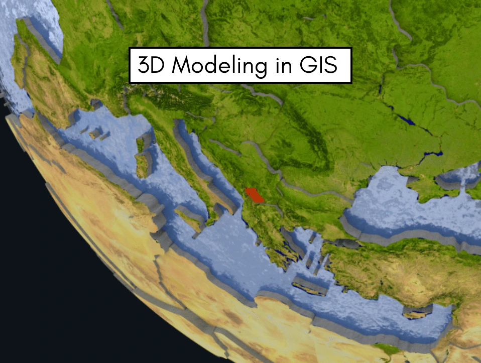
By incorporating elevation, depth, and height into geographic representations, 3D GIS modelling is completely changing how we interpret spatial data. As real-world spatial issues and urban development requirements become more complicated, 3D GIS offers a more sophisticated and immersive viewpoint than conventional 2D GIS systems.
These improvements facilitate better stakeholder communication, analysis, and decision-making. 3D GIS provides revolutionary capabilities that influence the direction of geospatial analysis, whether it is used for disaster scenario modelling or smart city planning.
Understanding 3D Modeling in GIS
By incorporating elevation, depth, and height into geographic representations, 3D GIS modelling is completely changing how we interpret spatial data. As real-world spatial issues and urban development requirements become more complicated, 3D GIS offers a more sophisticated and immersive viewpoint than conventional 2D GIS systems.
These improvements facilitate better stakeholder communication, analysis, and decision-making. 3D GIS provides revolutionary capabilities that influence the direction of geospatial analysis, whether it is used for disaster scenario modelling or smart city planning.
Types of 3D Data in GIS
1. Digital Elevation Model (DEM)
- A DEM represents the bare Earth’s surface elevation without buildings or vegetation.
- It is raster-based, where each pixel holds a height value above sea level.
- DEM is essential for terrain analysis, slope, and watershed modeling.
- It is commonly used in flood simulations and landscape planning.
- DEM data is often derived from satellites or LiDAR.
2. Digital Surface Model (DSM)
- DSM includes all surface features like trees, buildings, and infrastructure.
- It captures the topmost surface elevation visible from above.
- Useful for telecom tower placement, visibility, and shadow analysis.
- It reflects the real-world urban and forest canopy structure.
- DSM is produced using LiDAR or aerial photogrammetry
3. Digital Terrain Model (DTM)
- A DTM is an enhanced DEM with added terrain features like break lines or contours.
- It provides a more accurate surface for engineering and design tasks.
- DTMs are widely used in construction, road, and railway projects.
- They offer smoother and more refined elevation data than DEM.
- They are created using surveyed data or enhanced DEM.
4. LiDAR Point Clouds
- LiDAR uses laser pulses to generate dense 3D point clouds of the Earth’s surface.
- Each point has x, y, and z coordinates, often with classification (e.g., ground, tree).
- Used in forestry, urban mapping, flood modeling, and infrastructure planning.
- LiDAR provides high-resolution and highly accurate spatial data.
- It can be airborne (drones/planes) or ground-based.
5. Photogrammetric 3D Models
- These are generated from overlapping 2D images using triangulation.
- Photogrammetry reconstructs 3D surfaces, often from drones or aerial platforms.
- Useful in construction monitoring, archaeology, and mining.
- It’s a cost-effective alternative to LiDAR for 3D data.
- Models can include both terrain and built structures.
6. Triangulated Irregular Network (TIN)
- TINs are vector-based 3D surface models made from connected triangles.
- They represent elevation data with variable point density and precision.
- TIN is used in terrain modeling, slope stability, and contour generation.
- It allows accurate modeling of rugged or detailed surfaces.
- TINs are suitable for site-specific engineering and geological studies.
7. Building Models (LOD1–LOD4)
- LOD (Level of Detail) models range from simple blocks (LOD1) to detailed interiors (LOD4).
- These are 3D representations of buildings with increasing detail.
- Used in urban planning, disaster response, and smart city applications.
- LOD3 and LOD4 support high-fidelity architectural visualization.
- They are built using LiDAR, photogrammetry, or BIM data.
8. Subsurface and 4D Data
- Subsurface models represent underground layers like geology, aquifers, and tunnels.
- 4D GIS adds the time dimension, tracking changes over time in 3D space.
- Used in groundwater modeling, oil/gas exploration, and mining.
- Created from borehole data, seismic surveys, and geologic maps.
- Enables dynamic simulation and analysis of underground systems.
Software and Tools for 3D GIS
3D GIS modeling is revolutionizing the way we understand spatial data by integrating height, depth, and elevation into geographic representations. With the increasing complexity of real-world spatial problems and urban development needs, 3D GIS provides an advanced and immersive perspective to traditional 2D GIS systems. These enhancements support improved analysis, decision-making, and stakeholder communication. Whether it’s planning smart cities or modeling disaster scenarios, 3D GIS offers transformative capabilities that shape the future of geospatial analysis.
Applications of 3D GIS Modeling
3D GIS modeling is revolutionizing the way we understand spatial data by integrating height, depth, and elevation into geographic representations. With the increasing complexity of real-world spatial problems and urban development needs, 3D GIS provides an advanced and immersive perspective to traditional 2D GIS systems. These enhancements support improved analysis, decision-making, and stakeholder communication. Whether it’s planning smart cities or modeling disaster scenarios, 3D GIS offers transformative capabilities that shape the future of geospatial analysis.
Benefits of 3D GIS Modeling
3D GIS modeling has transformed the way spatial data is visualized, analyzed, and communicated across a wide range of sectors. By adding depth and elevation to traditional 2D representations, it unlocks a more realistic understanding of geographic features, built environments, and underground systems. This enriched spatial perspective offers numerous benefits for decision-makers, planners, engineers, and researchers alike.
One of the most significant advantages is enhanced visualization. 3D GIS enables users to see terrain, infrastructure, and landscapes in a way that mimics the real world. From viewing multi-story buildings in urban environments to visualizing mountainous terrain with true elevation, 3D models provide an intuitive experience that improves understanding among both experts and non-technical stakeholders. This is especially valuable in urban planning, where citizens and policymakers can visualize proposed developments before they are built.
Another key benefit is improved spatial analysis. 3D GIS allows users to measure volume, calculate visibility (e.g., line-of-sight analysis), analyze shadow impacts, and assess viewsheds with greater accuracy. In environmental management, it enables precise floodplain modeling, landslide risk assessment, and forest canopy studies — all of which depend on elevation data. For underground utilities or mining operations, subsurface modeling ensures safer and more efficient planning.
3D GIS also strengthens decision-making by offering multi-dimensional insights. For example, in disaster risk management, it supports simulation of flood inundation levels, evacuation route modeling, and infrastructure vulnerability analysis. These models help emergency planners prepare for various scenarios and allocate resources more effectively. Similarly, in the construction and engineering sectors, 3D GIS facilitates clash detection, project coordination, and lifecycle monitoring when integrated with BIM (Building Information Modeling).
The integration of time (4D GIS) further enhances the benefits, allowing dynamic visualization of change over time. This is particularly useful in tracking urban expansion, glacier retreat, or vegetation growth. As data is updated, decision-makers can monitor progress and evaluate the impact of interventions in near real-time.

Additionally, 3D GIS improves communication and stakeholder engagement. Interactive 3D maps, web-based viewers, and fly-through animations allow non-experts to understand complex geospatial information easily. This leads to better public participation and transparency in planning processes.
In conclusion, 3D GIS modeling offers a powerful toolkit for analysis, planning, and communication. Its ability to combine realism with analytical precision makes it a vital component in modern spatial science and data-driven governance.
Challenges in 3D GIS Implementation
Despite its immense potential, implementing 3D GIS comes with several technical, organizational, and financial challenges that organizations must navigate carefully. Unlike traditional 2D GIS, the transition to three-dimensional spatial analysis requires more sophisticated systems, deeper expertise, and tailored workflows.
One of the primary challenges is data acquisition and quality. Capturing accurate 3D spatial data often involves expensive tools such as LiDAR scanners, UAVs, or high-resolution satellite imagery. Even when these tools are available, ensuring the precision and consistency of elevation data, building models, or subsurface layers is difficult. Variations in resolution, vertical accuracy, and classification errors can significantly affect modeling outputs and decision-making.
Another significant issue is data volume and storage. 3D datasets are often large and complex, requiring high-performance computing infrastructure for storage, visualization, and analysis. Traditional GIS systems or organizational servers may not be optimized to handle terabytes of LiDAR point clouds or high-resolution terrain meshes, resulting in slow performance or system crashes.
Software compatibility and interoperability is also a critical hurdle. Not all GIS platforms support 3D data formats effectively, and many lack tools for integrating 3D models with Building Information Modeling (BIM), CAD, or virtual reality (VR) systems. Moving data between platforms can result in information loss or formatting errors, especially when working across teams or industries.
Technical expertise and training are further bottlenecks. The successful use of 3D GIS requires specialized skills in 3D modeling, scripting (e.g., Python for automation), and domain-specific knowledge such as urban planning or geology. Many institutions lack staff who are proficient in both GIS fundamentals and 3D analytical tools, creating a learning curve and slowing project timelines.
Moreover, cost is a consistent constraint. The hardware, software licenses, data acquisition tools, and training required to implement a full-scale 3D GIS system can be prohibitively expensive for small organizations, government departments, or universities in developing countries.
Finally, standardization and regulation present emerging challenges. As 3D GIS is still evolving, there are limited standards for data formats, metadata, or model accuracy across applications. This lack of consistency hinders data sharing, collaborative planning, and cross-border GIS projects.
In summary, while 3D GIS offers revolutionary capabilities in modeling and decision support, its implementation demands careful planning, significant investment, and cross-disciplinary collaboration to overcome technical, operational, and institutional barriers.
Integration with Emerging Technologies
3D GIS modeling is revolutionizing the way we understand spatial data by integrating height, depth, and elevation into geographic representations. With the increasing complexity of real-world spatial problems and urban development needs, 3D GIS provides an advanced and immersive perspective to traditional 2D GIS systems. These enhancements support improved analysis, decision-making, and stakeholder communication. Whether it’s planning smart cities or modeling disaster scenarios, 3D GIS offers transformative capabilities that shape the future of geospatial analysis.
3D GIS in Academic and Research Contexts
3D GIS modeling is revolutionizing the way we understand spatial data by integrating height, depth, and elevation into geographic representations. With the increasing complexity of real-world spatial problems and urban development needs, 3D GIS provides an advanced and immersive perspective to traditional 2D GIS systems. These enhancements support improved analysis, decision-making, and stakeholder communication. Whether it’s planning smart cities or modeling disaster scenarios, 3D GIS offers transformative capabilities that shape the future of geospatial analysis.
Future Trends in 3D GIS
3D GIS modeling is revolutionizing the way we understand spatial data by integrating height, depth, and elevation into geographic representations. With the increasing complexity of real-world spatial problems and urban development needs, 3D GIS provides an advanced and immersive perspective to traditional 2D GIS systems. These enhancements support improved analysis, decision-making, and stakeholder communication. Whether it’s planning smart cities or modeling disaster scenarios, 3D GIS offers transformative capabilities that shape the future of geospatial analysis.
Conclusion
3D GIS modeling is revolutionizing the way we understand spatial data by integrating height, depth, and elevation into geographic representations. With the increasing complexity of real-world spatial problems and urban development needs, 3D GIS provides an advanced and immersive perspective to traditional 2D GIS systems. These enhancements support improved analysis, decision-making, and stakeholder communication. Whether it’s planning smart cities or modeling disaster scenarios, 3D GIS offers transformative capabilities that shape the future of geospatial analysis.