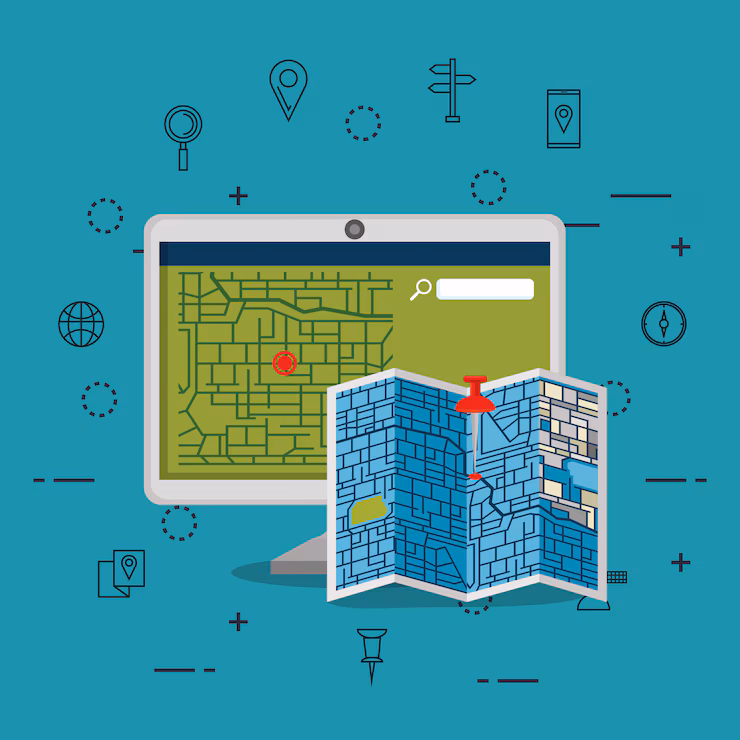
In today’s digital age, relying on old maps and physical records can slow down planning, decision-making, and progress. That’s where GIS digitization comes in. It’s the first and most crucial step in turning traditional geographic information into smart, searchable, and interactive digital maps.
In this blog, we’ll explore what digitization in GIS really means, how it works, the different methods used, and why it’s transforming industries from agriculture and urban planning to infrastructure and disaster management.
What does GIS digitization mean?
The process of transforming geographic data from analog representations-like paper maps, scanned photos, or aerial photographs, into digital formats that can be saved, examined, and altered on a computer is known as digitization in Geographic Information Systems (GIS).
This conversion makes it possible to represent real-world physical characteristics as digital layers made up of points, lines, and polygons, such as roads, rivers, property parcels, and elevation contours.
When creating a digital GIS database, digitization is frequently the first and most important stage. In order to produce vector data (shapes and boundaries) or raster data (grids or images), it entails tracking map characteristics using GIS software, either manually or with automated methods. After being digitalized, this data becomes dynamic and interactive, allowing users to create themed maps for decision-making, model scenarios, integrate with real-time data, and conduct spatial analysis.
GIS digitization, to put it simply, is the process of giving old-fashioned paper maps a digital life by enabling search, editing, and analysis. In domains where precise geographical data is essential for planning and policy creation, such as urban planning, land management, disaster response, agriculture, infrastructure development, and environmental conservation, this digital revolution is essential.
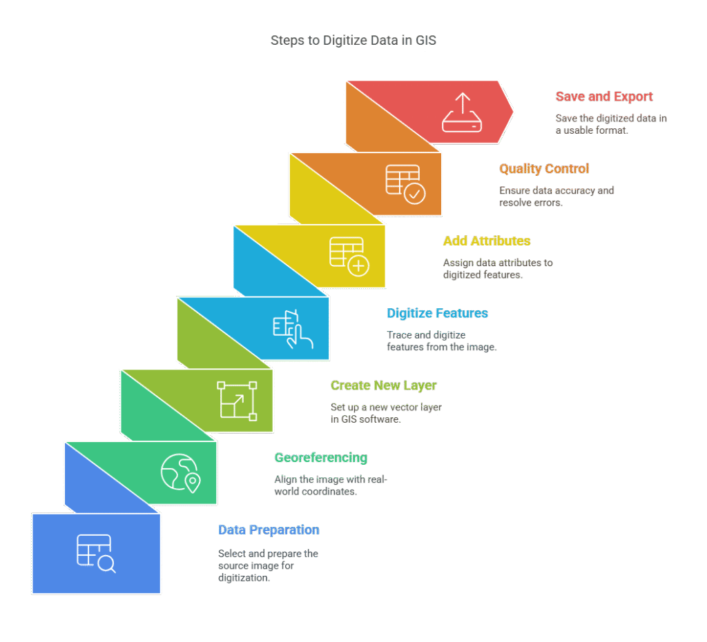
How to Digitize Data in GIS
Using specialized GIS software like ArcGIS, QGIS, or Global Mapper, non-digital maps or photos are transformed into digital vector data. Using sources like scanned paper maps, satellite photos, or aerial photography to create precise and editable spatial datasets requires this procedure.
Data Preparation
Choose your source document, satellite picture, or map first. Make sure the picture includes all the features you need for digitization and is clear. Save it in a raster format that works with it, such as PNG, TIFF, or JPEG.
Georeferencing the Image
The image needs to line up with actual coordinates before digitization can begin. This is accomplished by georeferencing, which involves giving the image spatial reference points (such as control points from GPS data or known latitude/longitude values) so that it fits precisely on a map.
Creating a New Layer
To save the digitized features, open your GIS program (such as QGIS or ArcGIS) and make a new vector layer. Select the type of geometry you wish to digitize: polygon, line, or point.
Digitizing the Features
Tracing the features comes next after the raster image has been prepared. Small items like trees or wells are represented by points, highways and rivers by lines, and larger areas like lakes or land parcels by polygons. Usually, a mouse or the sketching tool in the GIS software is used to accomplish this manually, recording the positions and forms for later study.
Adding Attribute Data
There should be a name, type, or ID assigned to each digitized feature. Since the data is kept in an attribute table, it can be used for analysis.
Perform Quality Control
Check the accuracy of your data. Resolve problems such as gaps, overlapping lines, or misplaced features. In order to verify spatial linkages, use topology tools.
Save and Export the Data
After everything is tidy, save your digital layer in a Shapefile or GeoJSON format so that it may be used for mapping or analysis later.
Need Professional GIS Digitization Services?
Contact NowTypes of digitization
Here are the main types of digitization commonly used, especially in the context of Geographic Information Systems (GIS) and data management:
Manual digitization
Manual digitization involves manually tracing features from a map or image to convert analog data into digital form.In this technique, lines, points, or polygons are usually drawn using GIS software or digitizing tablets. It can be labor-intensive and time-consuming, despite its high accuracy and ability to provide fine-grained control over data quality.
Automatic digitization
On the other hand, automatic digitization uses software algorithms to automatically convert raster data (like scanned maps or satellite images) into vector format. To extract features, methods like thresholding and edge detection are frequently employed. For large datasets, this approach is quick and effective, but it can introduce errors and needs rigorous post-processing to guarantee accuracy.
Semi-automatic digitization
Semi-automatic digitization is a hybrid approach that combines manual and automatic methods. While a human operator oversees the process and fixes errors as they arise, the software does the initial digitizing. This approach balances accuracy and efficiency, making it appropriate for jobs requiring a certain amount of physical labor.
Photogrammetric digitalization
Aerial or satellite photos are converted into 3D data using photogrammetric digitalization. Digital elevation models (DEMs) and topographic maps are created by measuring the coordinates of features in stereo pictures. Urban planning, topography analysis, and producing high-precision 3D data from aerial surveys all depend on this technique.
Differences between manual and automatic digitizing
| Aspect | Manual Digitizing | Automatic Digitizing |
| Process | Features are traced manually using GIS software or digitizing tablet | Software algorithms extract features automatically from raster images |
| Accuracy | Highly accurate due to human supervision | Accuracy may vary; can include errors and noise |
| Speed | Slow and time-consuming | Fast and efficient for large datasets |
| Human Involvement | High; full control over each feature | Minimal; requires some supervision or post-processing |
| Cost & Labor | Labor-intensive and more expensive in terms of time and resources | Less labor-intensive; cost-effective for bulk data |
| Best Use Care | Small-scale, high-precision tasks (e.g., cadastral maps) | Large-scale raster data (e.g., satellite images, scanned topographic maps) |
Advantages of Digitization in GIS:
The transition from analog to digital systems has changed how information is stored, retrieved, and used in today’s fast-paced digital world. Digitization is essential for increasing productivity, cutting expenses, and facilitating more intelligent decision-making. The shift to digital data provides numerous advantages for field operations, private businesses, and government offices. The benefits of digitalization are extensive and significant, ranging from improving customer happiness to optimizing workflows.
Below are some of the most important benefits explained in detail:
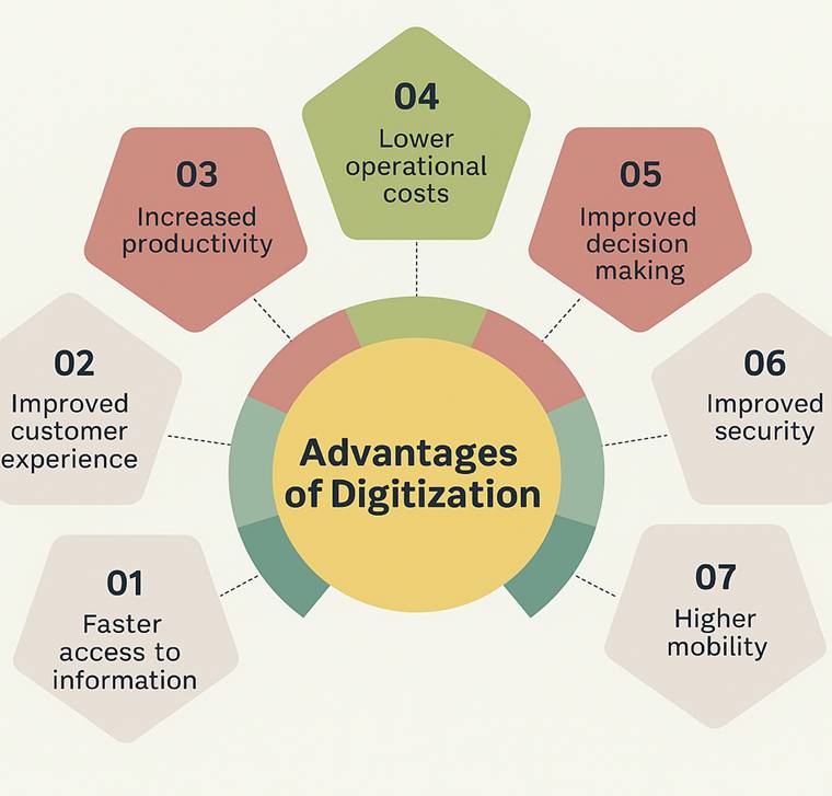
Advantages of Digitization
1. Faster Information Access
Data, documents, maps, and records may all be accessed instantly thanks to digitization. With just a few clicks, users may rapidly obtain the necessary information rather than wasting hours looking through paper files. In time-sensitive situations like emergency preparedness, healthcare, or government, this results in better outcomes, faster reactions, and greater coordination.
2. Improved Customer Experience
Digital tools such as mobile applications, chatbots, and websites allow businesses to provide services and assistance around-the-clock. Consumers can get what they need at any time, from any location, without having to wait in lines or make repeated calls. Stronger bonds and increased client satisfaction are the results of this convenience.
3.Increased Productivity
Time and effort are saved when repetitive processes like data input, reporting, and document processing are automated. Workers can devote more of their attention to strategic or creative work rather than monotonous duties. Teams are able to operate more efficiently and quickly as a result, increasing total production.
4. Lower Operational Costs
Physical storage, filing cabinets, paper, and printing are all less necessary as a result of digitization. Costly infrastructure is replaced with cloud-based solutions, which also drastically reduce administrative expenses. These savings have the potential to significantly impact operating budgets over time.
5. Better Ability to Make Decisions
Organizations may make well-informed decisions based on facts rather than conjecture by using real-time data dashboards and reporting technologies. This enables leaders to more efficiently create strategy, assess performance, and react to trends. Making decisions based on data reduces risks and produces better outcomes.
6. Enhanced Protection
Digital data can be password-protected, encrypted, and automatically backed up, unlike physical files. It is less probable that private data will be misplaced, harmed, or accessed without authorization. Additionally, by providing improved control and traceability, digital systems aid in adherence to data protection laws.
7. Increased Mobility
Remote access to digital data is possible via laptops, tablets, or cellphones. This facilitates real-time collaboration for teams operating remotely, in the field, or in different locations. In industries that move quickly, greater mobility promotes flexible work arrangements and improves service delivery.
Custom Geospatial Survey & Digitization Services– AI Geo Navigator
AI Geo Navigator offers tailored Geospatial Survey and Digitization Services designed to meet the unique needs of public and private sector clients. From high-precision mapping to the digital conversion of spatial data, our team leverages cutting-edge GIS tools and remote sensing technology to deliver accurate, reliable, and actionable insights.
Whether it’s for land records, infrastructure planning, or environmental monitoring, we provide end-to-end solutions that support smarter decision-making and efficient data management.